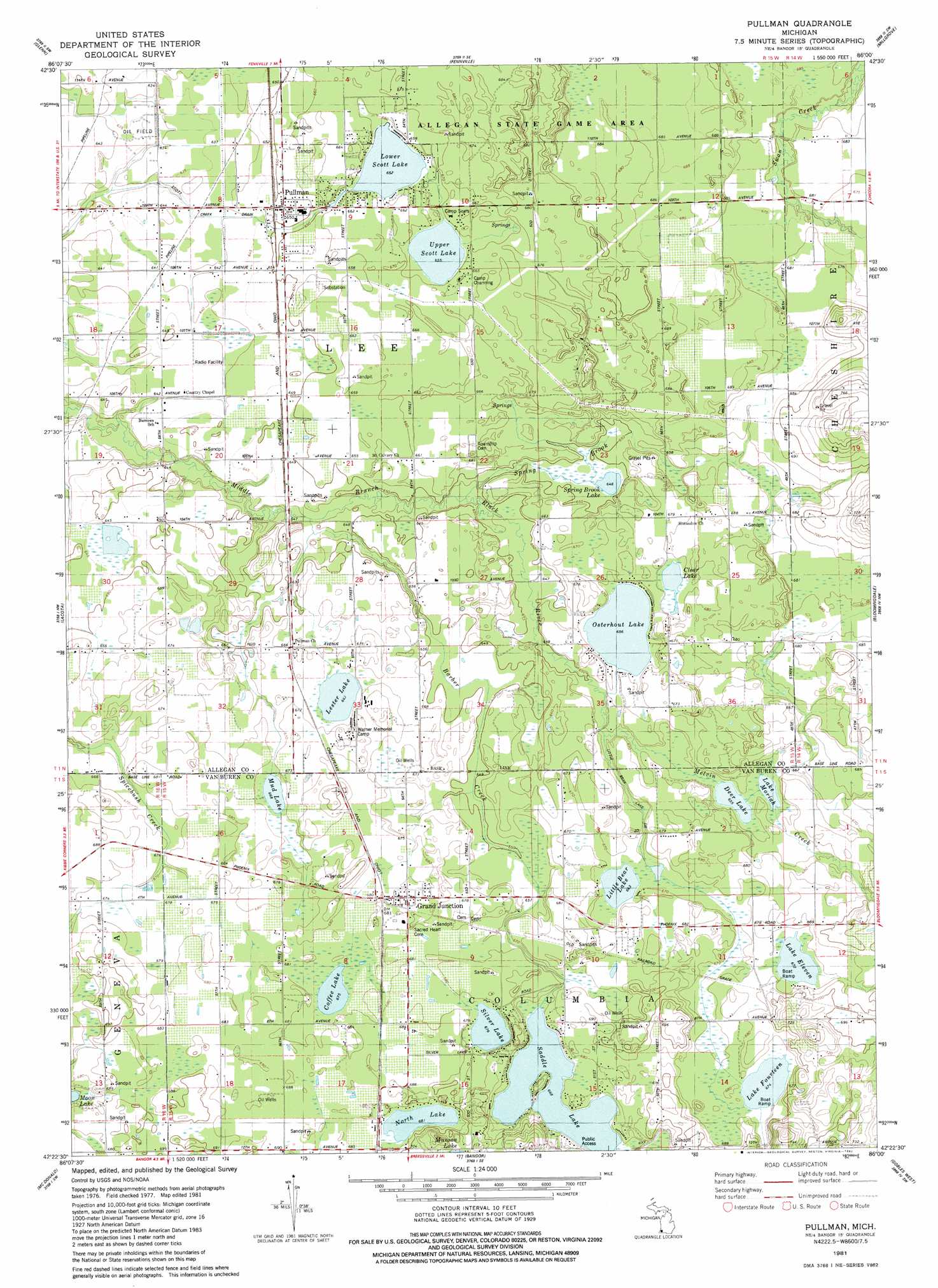
Pullman Topo Map Michigan
To zoom in, hover over the map of Pullman
USGS Topo Quad 42086d1 - 1:24,000 scale
| Topo Map Name: | Pullman |
| USGS Topo Quad ID: | 42086d1 |
| Print Size: | ca. 21 1/4" wide x 27" high |
| Southeast Coordinates: | 42.375° N latitude / 86° W longitude |
| Map Center Coordinates: | 42.4375° N latitude / 86.0625° W longitude |
| U.S. State: | MI |
| Filename: | o42086d1.jpg |
| Download Map JPG Image: | Pullman topo map 1:24,000 scale |
| Map Type: | Topographic |
| Topo Series: | 7.5´ |
| Map Scale: | 1:24,000 |
| Source of Map Images: | United States Geological Survey (USGS) |
| Alternate Map Versions: |
Pullman MI 1981, updated 1982 Download PDF Buy paper map Pullman MI 2011 Download PDF Buy paper map Pullman MI 2014 Download PDF Buy paper map Pullman MI 2017 Download PDF Buy paper map |
1:24,000 Topo Quads surrounding Pullman
Saugatuck |
Hamilton West |
Hamilton East |
Burnips |
|
Glenn |
Fennville |
Millgrove |
Allegan |
|
South Haven |
Lacota |
Pullman |
Bloomingdale |
Merson |
Covert |
Mcdonald |
Bangor |
Gobles West |
Gobles East |
Coloma |
Hartford |
Lawrence |
Paw Paw |
Lawton |
> Back to 42086a1 at 1:100,000 scale
> Back to 42086a1 at 1:250,000 scale
> Back to U.S. Topo Maps home
Pullman topo map: Gazetteer
Pullman: Canals
Drum Ditch elevation 195m 639′Pullman: Lakes
Clear Lake elevation 206m 675′Coffee Lake elevation 206m 675′
Deer Lake elevation 200m 656′
Lake Eleven elevation 205m 672′
Lake Fourteen elevation 205m 672′
Lake Moriah elevation 200m 656′
Lester Lake elevation 202m 662′
Little Bear Lake elevation 202m 662′
Lower Scott Lake elevation 199m 652′
Mud Lake elevation 203m 666′
North Lake elevation 207m 679′
Osterhout Lake elevation 200m 656′
Saddle Lake elevation 203m 666′
Silver Lake elevation 206m 675′
Spring Brook Lake elevation 197m 646′
Upper Scott Lake elevation 200m 656′
Pullman: Populated Places
Bakersville elevation 201m 659′Grand Junction elevation 207m 679′
Lee elevation 197m 646′
Pullman elevation 199m 652′
Sherman Park elevation 203m 666′
Pullman: Post Offices
Avis Post Office (historical) elevation 195m 639′Grand Junction Post Office elevation 207m 679′
Horseshoe Post Office (historical) elevation 205m 672′
Lee Post Office (historical) elevation 197m 646′
Pullman Post Office elevation 199m 652′
Saddle Lake Post Office (historical) elevation 204m 669′
Pullman: Streams
Barber Creek elevation 193m 633′Little Bear Lake Drain elevation 204m 669′
Melvin Creek elevation 204m 669′
Spring Brook elevation 194m 636′
Pullman digital topo map on disk
Buy this Pullman topo map showing relief, roads, GPS coordinates and other geographical features, as a high-resolution digital map file on DVD:
Northern Illinois, Northern Indiana & Southwestern Michigan
Buy digital topo maps: Northern Illinois, Northern Indiana & Southwestern Michigan