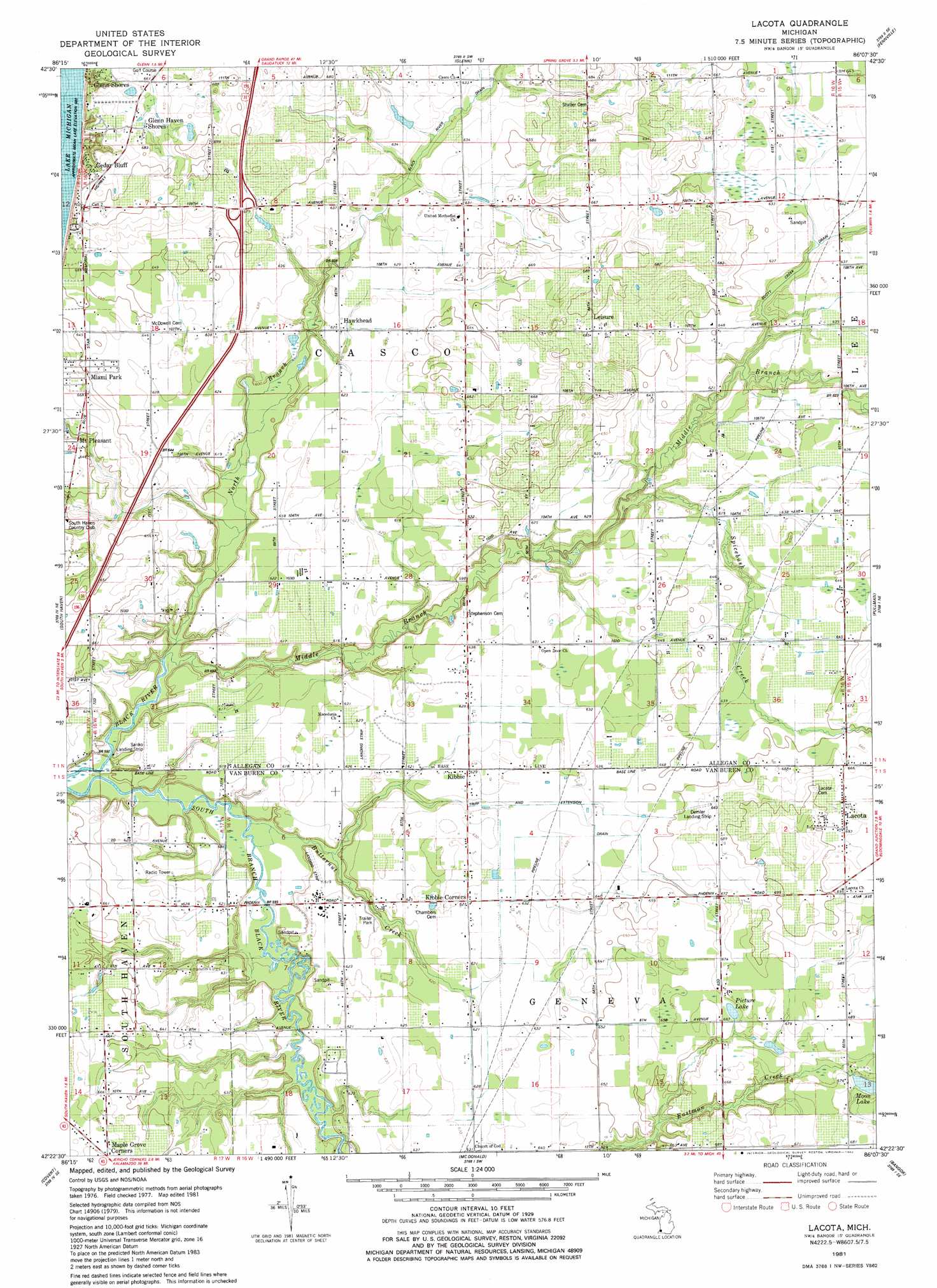
Lacota Topo Map Michigan
To zoom in, hover over the map of Lacota
USGS Topo Quad 42086d2 - 1:24,000 scale
| Topo Map Name: | Lacota |
| USGS Topo Quad ID: | 42086d2 |
| Print Size: | ca. 21 1/4" wide x 27" high |
| Southeast Coordinates: | 42.375° N latitude / 86.125° W longitude |
| Map Center Coordinates: | 42.4375° N latitude / 86.1875° W longitude |
| U.S. State: | MI |
| Filename: | o42086d2.jpg |
| Download Map JPG Image: | Lacota topo map 1:24,000 scale |
| Map Type: | Topographic |
| Topo Series: | 7.5´ |
| Map Scale: | 1:24,000 |
| Source of Map Images: | United States Geological Survey (USGS) |
| Alternate Map Versions: |
Lacota MI 1981, updated 1982 Download PDF Buy paper map Lacota MI 2011 Download PDF Buy paper map Lacota MI 2014 Download PDF Buy paper map Lacota MI 2017 Download PDF Buy paper map |
1:24,000 Topo Quads surrounding Lacota
Saugatuck |
Hamilton West |
Hamilton East |
||
Glenn |
Fennville |
Millgrove |
||
South Haven |
Lacota |
Pullman |
Bloomingdale |
|
Covert |
Mcdonald |
Bangor |
Gobles West |
|
Benton Heights |
Coloma |
Hartford |
Lawrence |
Paw Paw |
> Back to 42086a1 at 1:100,000 scale
> Back to 42086a1 at 1:250,000 scale
> Back to U.S. Topo Maps home
Lacota topo map: Gazetteer
Lacota: Airports
Demler Landing Strip elevation 200m 656′Sanko Landing Strip elevation 186m 610′
Trowbridge Farms Airport elevation 193m 633′
Walle Field elevation 194m 636′
Lacota: Crossings
Interchange 26 elevation 202m 662′Lacota: Lakes
Manitt Lake elevation 188m 616′Moon Lake elevation 200m 656′
Picture Lake elevation 203m 666′
Lacota: Populated Places
Cedar Bluff elevation 210m 688′Glenn Haven Shores elevation 207m 679′
Glenn Stores elevation 201m 659′
Hawkhead elevation 189m 620′
Hollywood elevation 206m 675′
Kibbie elevation 191m 626′
Lacota elevation 211m 692′
Leisure elevation 209m 685′
Maple Grove Corners elevation 208m 682′
Mount Pleasant elevation 199m 652′
Sulphur Springs elevation 178m 583′
Whispering Pines Estates and Mobile Home Park elevation 187m 613′
Lacota: Post Offices
Hawkhead Post Office (historical) elevation 189m 620′Kibbie Post Office (historical) elevation 191m 626′
Lacota Post Office elevation 211m 692′
Leisure Post Office (historical) elevation 209m 685′
West Casco Post Office (historical) elevation 198m 649′
Lacota: Streams
Black River Drain elevation 185m 606′Butternut Creek elevation 178m 583′
Eastman Creek elevation 188m 616′
Elm Creek Drain elevation 187m 613′
Middle Branch Black River elevation 178m 583′
North Branch Black River elevation 178m 583′
Ockford Drain elevation 192m 629′
Scott Creek Drain elevation 184m 603′
Spicebush Creek elevation 183m 600′
Tripp and Extension Drain elevation 182m 597′
Lacota digital topo map on disk
Buy this Lacota topo map showing relief, roads, GPS coordinates and other geographical features, as a high-resolution digital map file on DVD:
Northern Illinois, Northern Indiana & Southwestern Michigan
Buy digital topo maps: Northern Illinois, Northern Indiana & Southwestern Michigan