Fennville Topo Map Michigan
To zoom in, hover over the map of Fennville
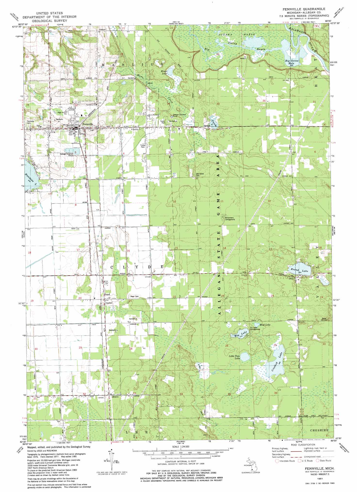
USGS Topo Quad 42086e1 - 1:24,000 scale
| Topo Map Name: | Fennville |
| USGS Topo Quad ID: | 42086e1 |
| Print Size: | ca. 21 1/4" wide x 27" high |
| Southeast Coordinates: | 42.5° N latitude / 86° W longitude |
| Map Center Coordinates: | 42.5625° N latitude / 86.0625° W longitude |
| U.S. State: | MI |
| Filename: | o42086e1.jpg |
| Download Map JPG Image: | Fennville topo map 1:24,000 scale |
| Map Type: | Topographic |
| Topo Series: | 7.5´ |
| Map Scale: | 1:24,000 |
| Source of Map Images: | United States Geological Survey (USGS) |
| Alternate Map Versions: |
Fennville MI 1981, updated 1982 Download PDF Buy paper map Fennville MI 2011 Download PDF Buy paper map Fennville MI 2014 Download PDF Buy paper map Fennville MI 2017 Download PDF Buy paper map |
1:24,000 Topo Quads surrounding Fennville
Holland West |
Holland East |
Hudsonville West |
Hudsonville East |
|
Saugatuck |
Hamilton West |
Hamilton East |
Burnips |
|
Glenn |
Fennville |
Millgrove |
Allegan |
|
South Haven |
Lacota |
Pullman |
Bloomingdale |
Merson |
Covert |
Mcdonald |
Bangor |
Gobles West |
Gobles East |
> Back to 42086e1 at 1:100,000 scale
> Back to 42086a1 at 1:250,000 scale
> Back to U.S. Topo Maps home
Fennville topo map: Gazetteer
Fennville: Canals
Leverich Drain elevation 195m 639′Utter Drain elevation 201m 659′
Fennville: Flats
Pine Plains elevation 197m 646′Fennville: Guts
Big Dailey Bayou elevation 192m 629′Fennville: Lakes
Big Goose Lake elevation 179m 587′Crooked Lake elevation 203m 666′
Ely Lake elevation 205m 672′
Little Tom Lake elevation 203m 666′
Miner Lake elevation 188m 616′
Mud Lake elevation 205m 672′
Perch Lake elevation 191m 626′
Round Lake elevation 198m 649′
Fennville: Populated Places
Bravo elevation 203m 666′Dogwood Manor Mobile Home Park elevation 194m 636′
Fennville elevation 202m 662′
Pearl elevation 199m 652′
Fennville: Post Offices
Bravo Post Office (historical) elevation 203m 666′Fennville Post Office elevation 201m 659′
Pearl Post Office (historical) elevation 199m 652′
Fennville: Swamps
Ottawa Marsh elevation 180m 590′Fennville digital topo map on disk
Buy this Fennville topo map showing relief, roads, GPS coordinates and other geographical features, as a high-resolution digital map file on DVD:
Northern Illinois, Northern Indiana & Southwestern Michigan
Buy digital topo maps: Northern Illinois, Northern Indiana & Southwestern Michigan