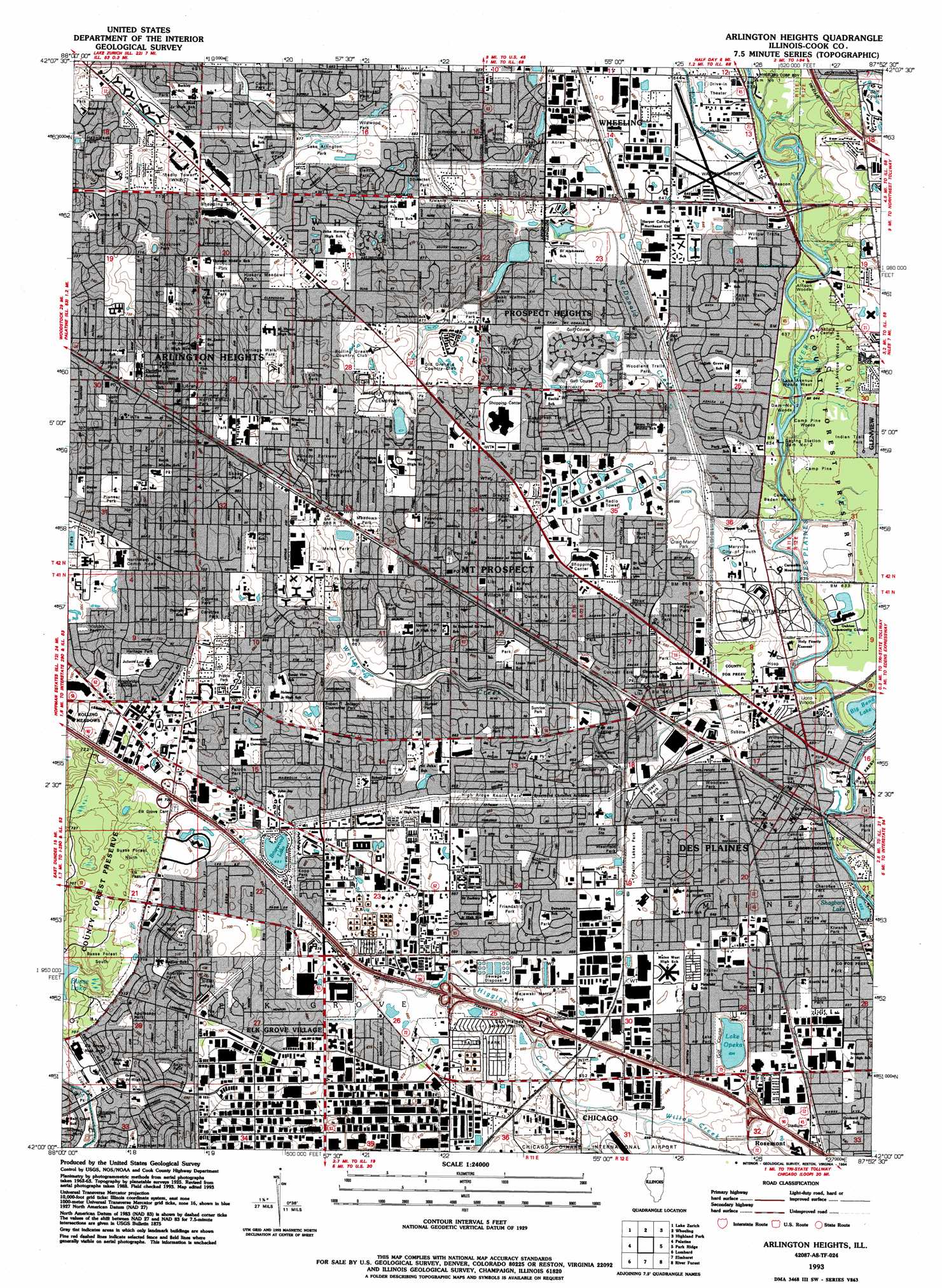
Arlington Heights Topo Map Illinois
To zoom in, hover over the map of Arlington Heights
USGS Topo Quad 42087a8 - 1:24,000 scale
| Topo Map Name: | Arlington Heights |
| USGS Topo Quad ID: | 42087a8 |
| Print Size: | ca. 21 1/4" wide x 27" high |
| Southeast Coordinates: | 42° N latitude / 87.875° W longitude |
| Map Center Coordinates: | 42.0625° N latitude / 87.9375° W longitude |
| U.S. State: | IL |
| Filename: | o42087a8.jpg |
| Download Map JPG Image: | Arlington Heights topo map 1:24,000 scale |
| Map Type: | Topographic |
| Topo Series: | 7.5´ |
| Map Scale: | 1:24,000 |
| Source of Map Images: | United States Geological Survey (USGS) |
| Alternate Map Versions: |
Arlington Heights IL 1927 Download PDF Buy paper map Arlington Heights IL 1927, updated 1934 Download PDF Buy paper map Arlington Heights IL 1927, updated 1946 Download PDF Buy paper map Arlington Heights IL 1953, updated 1955 Download PDF Buy paper map Arlington Heights IL 1962, updated 1973 Download PDF Buy paper map Arlington Heights IL 1963, updated 1964 Download PDF Buy paper map Arlington Heights IL 1963, updated 1981 Download PDF Buy paper map Arlington Heights IL 1993, updated 1994 Download PDF Buy paper map Arlington Heights IL 1995, updated 1999 Download PDF Buy paper map Arlington Heights IL 2012 Download PDF Buy paper map Arlington Heights IL 2015 Download PDF Buy paper map |
1:24,000 Topo Quads surrounding Arlington Heights
Wauconda |
Grayslake |
Libertyville |
Waukegan |
|
Barrington |
Lake Zurich |
Wheeling |
Highland Park |
|
Streamwood |
Palatine |
Arlington Heights |
Park Ridge |
Evanston |
West Chicago |
Lombard |
Elmhurst |
River Forest |
Chicago Loop |
Naperville |
Wheaton |
Hinsdale |
Berwyn |
Englewood |
> Back to 42087a1 at 1:100,000 scale
> Back to 42086a1 at 1:250,000 scale
> Back to U.S. Topo Maps home
Arlington Heights topo map: Gazetteer
Arlington Heights: Airports
Holy Family Hospital Heliport elevation 195m 639′Pal-Waukee Airport elevation 195m 639′
Arlington Heights: Canals
Feehanville Ditch elevation 196m 643′Arlington Heights: Dams
Dam Number 1 elevation 191m 626′Dam Number 2 elevation 190m 623′
Arlington Heights: Flats
Elk Pasture elevation 218m 715′Arlington Heights: Lakes
Big Bend Lake elevation 190m 623′Des Plaines Lake elevation 192m 629′
Lake Opeka elevation 192m 629′
Shagbark Lake elevation 190m 623′
Arlington Heights: Parks
Andrews Park elevation 216m 708′Apache Park elevation 196m 643′
Appleseed Park elevation 214m 702′
Arlington Greens Park elevation 209m 685′
Aspen Trails Park elevation 196m 643′
Banta Park elevation 204m 669′
Bartrum Park elevation 211m 692′
Berbecker Park elevation 206m 675′
Blackhawk Park elevation 196m 643′
Bluett Park elevation 198m 649′
Burbank Park elevation 208m 682′
Burning Bush Trails Park elevation 195m 639′
Busse Park elevation 200m 656′
Camelot Park elevation 208m 682′
Carefree Park elevation 212m 695′
Carousel Park elevation 206m 675′
Carriage Walk Park elevation 211m 692′
Central Park elevation 195m 639′
Chautauqua Park elevation 191m 626′
Cherokee Park elevation 194m 636′
Cheyenne Park elevation 200m 656′
Chippewa Park elevation 197m 646′
Cornell Park elevation 201m 659′
Country Garden Park elevation 200m 656′
Countryside Park elevation 203m 666′
Craig Manor Park elevation 197m 646′
Cronin Park elevation 209m 685′
Cypress Park elevation 213m 698′
Des Plaines Manor Park elevation 194m 636′
Dimucci Park elevation 202m 662′
Dryden Park elevation 210m 688′
East Wedgewood Park elevation 204m 669′
Einstein Park elevation 200m 656′
Emerson Park elevation 203m 666′
Evergreen Park elevation 205m 672′
Evergreen Trails Park elevation 204m 669′
Fairview Park elevation 205m 672′
Falcon Park elevation 213m 698′
Festival Park elevation 221m 725′
Flentle Park elevation 206m 675′
Friendship Park elevation 202m 662′
Frontier Park elevation 218m 715′
Frost Park elevation 209m 685′
Greens Park elevation 209m 685′
Gregory Park elevation 204m 669′
Happiness Park elevation 218m 715′
Hasbrook Park elevation 216m 708′
Hawaii Park elevation 200m 656′
Heritage Park elevation 219m 718′
Hickory Meadows Park elevation 209m 685′
High Ridge Knolls Park elevation 200m 656′
Hill Street Park elevation 202m 662′
Indian Trail Park elevation 195m 639′
Isaak Walton Park elevation 198m 649′
Jaycee Park elevation 202m 662′
Jaycee Park elevation 195m 639′
Kingsbridge Arboretum elevation 219m 718′
Kiwanis Park elevation 205m 672′
Kiwanis Park elevation 193m 633′
Klehm Park elevation 206m 675′
Kopp Park elevation 210m 688′
Kuthen Park elevation 200m 656′
Lake Arlington Park elevation 205m 672′
Lake Park elevation 192m 629′
Last Four Acres Park elevation 202m 662′
Lions Park elevation 201m 659′
Lions Park elevation 208m 682′
Lions Park elevation 203m 666′
Majewski Metro Park elevation 198m 649′
Maple Trails Park elevation 199m 652′
McKay-Nealis Park elevation 194m 636′
Meadows Park elevation 207m 679′
Melas Park elevation 204m 669′
Memorial Park elevation 218m 715′
Methodist Park elevation 206m 675′
Midway Park elevation 214m 702′
Morton Park elevation 211m 692′
Muir Park elevation 201m 659′
North End Park elevation 218m 715′
North School Park elevation 212m 695′
Northshire Park elevation 197m 646′
Olmstead Park elevation 208m 682′
Olympic Park elevation 218m 715′
Osborn Park elevation 218m 715′
Owen Park elevation 199m 652′
Park Number 3 elevation 211m 692′
Patriot Park elevation 205m 672′
Pioneer Park elevation 210m 688′
Potawatomie Park elevation 195m 639′
Prairie Lakes Park elevation 198m 649′
Prairie Park elevation 213m 698′
Prospect Meadows Park elevation 205m 672′
Recreation Park elevation 207m 679′
Ridge Park elevation 218m 715′
Robert T Jackson Clearwater Park elevation 205m 672′
Roth Park elevation 202m 662′
Shaag Park elevation 207m 679′
Sioux Park elevation 199m 652′
Somerset Park elevation 202m 662′
South Park elevation 196m 643′
Sunrise Park elevation 197m 646′
Sunset Park elevation 202m 662′
Tamarack Park elevation 212m 695′
Teton Park elevation 200m 656′
Tomahawk Park elevation 197m 646′
Udall Park elevation 212m 695′
Victory Park elevation 211m 692′
Voltz Park elevation 218m 715′
We-Go Park elevation 206m 675′
Weller Creek Park elevation 200m 656′
West Park elevation 198m 649′
Westfield Park elevation 198m 649′
Wildwood Park elevation 204m 669′
Willow Park elevation 205m 672′
Willow Park elevation 193m 633′
Willow Trails Park elevation 195m 639′
Windsor Parkway Park elevation 207m 679′
Woodland Trails Park elevation 196m 643′
Woodlawn Park elevation 196m 643′
Arlington Heights: Populated Places
Arlington Heights elevation 214m 702′Des Plaines elevation 193m 633′
Elk Grove Village elevation 209m 685′
Forest River elevation 194m 636′
Mount Prospect elevation 204m 669′
Norma elevation 198m 649′
Northfield Woods elevation 197m 646′
Oasis Mobile Home Park elevation 200m 656′
Prospect Heights elevation 204m 669′
Riverview elevation 195m 639′
Schnells Corner elevation 218m 715′
Arlington Heights: Post Offices
Arlington Heights Post Office elevation 219m 718′Mount Prospect Post Office elevation 204m 669′
Arlington Heights: Streams
Buffalo Creek elevation 192m 629′Higgins Creek elevation 194m 636′
McDonald Creek elevation 190m 623′
Weller Creek elevation 190m 623′
Arlington Heights: Woods
Allison Woods elevation 192m 629′Busse Woods elevation 220m 721′
Dam Number 2 Woods elevation 195m 639′
Lake Avenue Woods East elevation 193m 633′
Lake Avenue Woods West elevation 191m 626′
Lions Woods elevation 193m 633′
Northwestern Woods elevation 190m 623′
Arlington Heights digital topo map on disk
Buy this Arlington Heights topo map showing relief, roads, GPS coordinates and other geographical features, as a high-resolution digital map file on DVD:
Northern Illinois, Northern Indiana & Southwestern Michigan
Buy digital topo maps: Northern Illinois, Northern Indiana & Southwestern Michigan