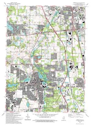
Libertyville Topo Map Illinois
To zoom in, hover over the map of Libertyville
USGS Topo Quad 42087c8 - 1:24,000 scale
| Topo Map Name: | Libertyville |
| USGS Topo Quad ID: | 42087c8 |
| Print Size: | ca. 21 1/4" wide x 27" high |
| Southeast Coordinates: | 42.25° N latitude / 87.875° W longitude |
| Map Center Coordinates: | 42.3125° N latitude / 87.9375° W longitude |
| U.S. State: | IL |
| Filename: | o42087c8.jpg |
| Download Map JPG Image: | Libertyville topo map 1:24,000 scale |
| Map Type: | Topographic |
| Topo Series: | 7.5´ |
| Map Scale: | 1:24,000 |
| Source of Map Images: | United States Geological Survey (USGS) |
| Alternate Map Versions: |
Libertyville IL 1960, updated 1962 Download PDF Buy paper map Libertyville IL 1960, updated 1973 Download PDF Buy paper map Libertyville IL 1960, updated 1981 Download PDF Buy paper map Libertyville IL 1960, updated 1989 Download PDF Buy paper map Libertyville IL 1993, updated 1993 Download PDF Buy paper map Libertyville IL 1998, updated 2002 Download PDF Buy paper map Libertyville IL 2012 Download PDF Buy paper map Libertyville IL 2015 Download PDF Buy paper map |
1:24,000 Topo Quads surrounding Libertyville
> Back to 42087a1 at 1:100,000 scale
> Back to 42086a1 at 1:250,000 scale
> Back to U.S. Topo Maps home
Libertyville topo map: Gazetteer
Libertyville: Airports
Condell Memorial Hospital Heliport elevation 220m 721′O John Clark RLA Airport elevation 242m 793′
Libertyville: Dams
Lake Charles Dam elevation 210m 688′Saint Marys Lake Dam elevation 215m 705′
Libertyville: Lakes
Gages Lake elevation 238m 780′Liberty Lake elevation 197m 646′
Minear Lake elevation 197m 646′
Twin Lakes elevation 234m 767′
Valley Lake elevation 234m 767′
Libertyville: Parks
Adler Memorial Park elevation 198m 649′Almond Marsh Forest Preserve elevation 229m 751′
Almond Marsh Nature Preserve elevation 224m 734′
Brown Park elevation 213m 698′
Butler Lake Park elevation 212m 695′
Century Park elevation 208m 682′
Dowden Park elevation 214m 702′
Gowe Park elevation 201m 659′
Green Tree Park elevation 217m 711′
Greenbelt County Forest Preserve elevation 216m 708′
Hanrahan Park elevation 219m 718′
Highland Memorial Park elevation 229m 751′
Independence Grove County Forest Preserve elevation 196m 643′
Liberty Prairie Nature Preserve elevation 215m 705′
MacArthur Woods Forest Preserve elevation 199m 652′
Meadowood Park elevation 202m 662′
Middle Fork Savanna County Forest Preserve elevation 203m 666′
Minear Park elevation 198m 649′
Old School Forest Preserve elevation 213m 698′
Red Top Park elevation 197m 646′
River Hill Forest Preserve elevation 208m 682′
Riverside Park elevation 198m 649′
Six Flags Great America elevation 218m 715′
South Park elevation 218m 715′
University Park elevation 207m 679′
Viking Park elevation 204m 669′
West Park elevation 212m 695′
Wilmot Woods Forest Preserve elevation 196m 643′
Woodlawn Park elevation 216m 708′
Libertyville: Populated Places
Bushs Corners elevation 222m 728′Creamery Corners elevation 211m 692′
Gages Lake elevation 234m 767′
Grange Hall elevation 232m 761′
Green Oaks elevation 210m 688′
Gurnee elevation 207m 679′
Harris Corners elevation 233m 764′
Idlewild elevation 244m 800′
Knollwood elevation 214m 702′
Libertyville elevation 213m 698′
Moran Corners elevation 213m 698′
Oak Grove elevation 213m 698′
Park City elevation 213m 698′
Rockefeller elevation 228m 748′
Rondout elevation 206m 675′
Sherman Corners elevation 207m 679′
Spaulding Corners elevation 220m 721′
Wells Corners elevation 218m 715′
Wildwood elevation 247m 810′
Wilson elevation 216m 708′
Libertyville: Reservoirs
Butler Lake elevation 211m 692′Lake Charles elevation 210m 688′
Lambs Lake elevation 210m 688′
Lucky Lake elevation 205m 672′
Saint Marys Lake elevation 215m 705′
Shady Lane Resort Lake elevation 207m 679′
Libertyville: Springs
White Sulphur Spring elevation 198m 649′Libertyville: Streams
Bull Creek elevation 197m 646′Libertyville digital topo map on disk
Buy this Libertyville topo map showing relief, roads, GPS coordinates and other geographical features, as a high-resolution digital map file on DVD:
Northern Illinois, Northern Indiana & Southwestern Michigan
Buy digital topo maps: Northern Illinois, Northern Indiana & Southwestern Michigan


