Pleasant Prairie Topo Map Wisconsin
To zoom in, hover over the map of Pleasant Prairie
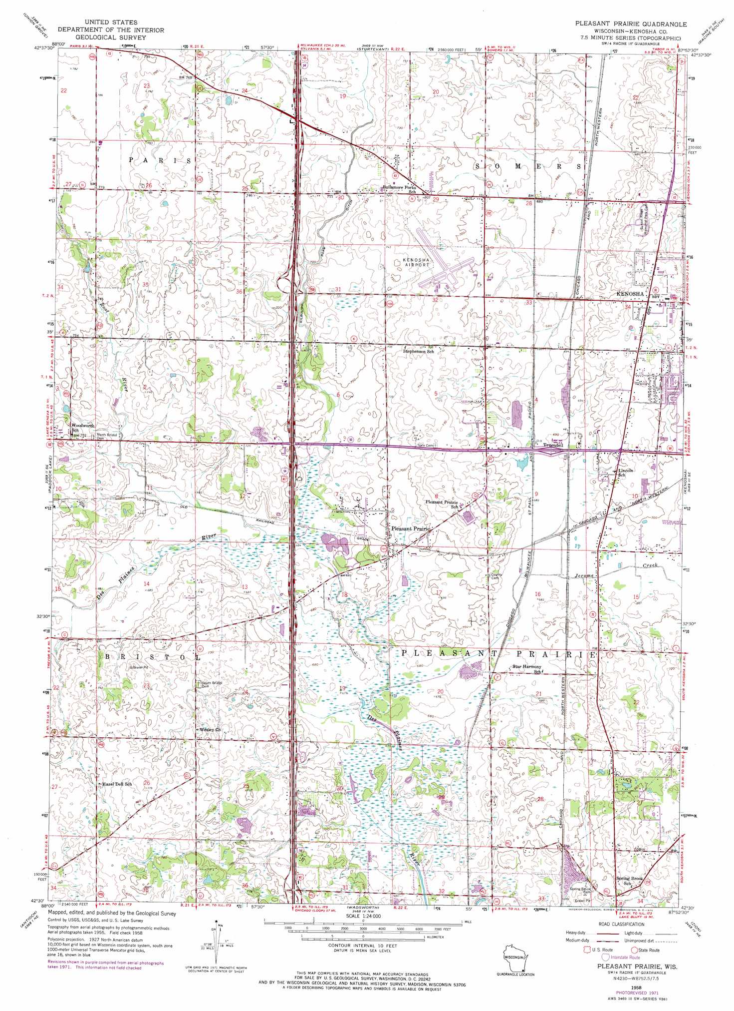
USGS Topo Quad 42087e8 - 1:24,000 scale
| Topo Map Name: | Pleasant Prairie |
| USGS Topo Quad ID: | 42087e8 |
| Print Size: | ca. 21 1/4" wide x 27" high |
| Southeast Coordinates: | 42.5° N latitude / 87.875° W longitude |
| Map Center Coordinates: | 42.5625° N latitude / 87.9375° W longitude |
| U.S. State: | WI |
| Filename: | o42087e8.jpg |
| Download Map JPG Image: | Pleasant Prairie topo map 1:24,000 scale |
| Map Type: | Topographic |
| Topo Series: | 7.5´ |
| Map Scale: | 1:24,000 |
| Source of Map Images: | United States Geological Survey (USGS) |
| Alternate Map Versions: |
Pleasant Prairie WI 1958, updated 1960 Download PDF Buy paper map Pleasant Prairie WI 1958, updated 1972 Download PDF Buy paper map Pleasant Prairie WI 2010 Download PDF Buy paper map Pleasant Prairie WI 2013 Download PDF Buy paper map Pleasant Prairie WI 2016 Download PDF Buy paper map |
1:24,000 Topo Quads surrounding Pleasant Prairie
Waterford |
North Cape |
Franksville |
Racine North |
|
Rochester |
Union Grove |
Sturtevant |
Racine South |
|
Silver Lake |
Paddock Lake |
Pleasant Prairie |
Kenosha |
|
Fox Lake |
Antioch |
Wadsworth |
Zion |
|
Wauconda |
Grayslake |
Libertyville |
Waukegan |
> Back to 42087e1 at 1:100,000 scale
> Back to 42086a1 at 1:250,000 scale
> Back to U.S. Topo Maps home
Pleasant Prairie topo map: Gazetteer
Pleasant Prairie: Airports
Kenosha Regional Airport elevation 223m 731′Thompson Strawberry Farm Airport elevation 223m 731′
Pleasant Prairie: Canals
Kilbourn Road Ditch elevation 212m 695′Pleasant Prairie: Crossings
Interchange 340 elevation 226m 741′Interchange 342 elevation 220m 721′
Interchange 344 elevation 216m 708′
Interchange 345 elevation 208m 682′
Interchange 347 elevation 216m 708′
Pleasant Prairie: Populated Places
Pleasant Prairie elevation 212m 695′Pleasant Prairie Mobile Home Court elevation 212m 695′
Prairie Lake Estates elevation 210m 688′
Truesdell elevation 210m 688′
Westwood Estates elevation 214m 702′
Pleasant Prairie: Streams
Jerome Creek elevation 204m 669′Root River elevation 207m 679′
Pleasant Prairie digital topo map on disk
Buy this Pleasant Prairie topo map showing relief, roads, GPS coordinates and other geographical features, as a high-resolution digital map file on DVD:
Northern Illinois, Northern Indiana & Southwestern Michigan
Buy digital topo maps: Northern Illinois, Northern Indiana & Southwestern Michigan