Lake Zurich Topo Map Illinois
To zoom in, hover over the map of Lake Zurich
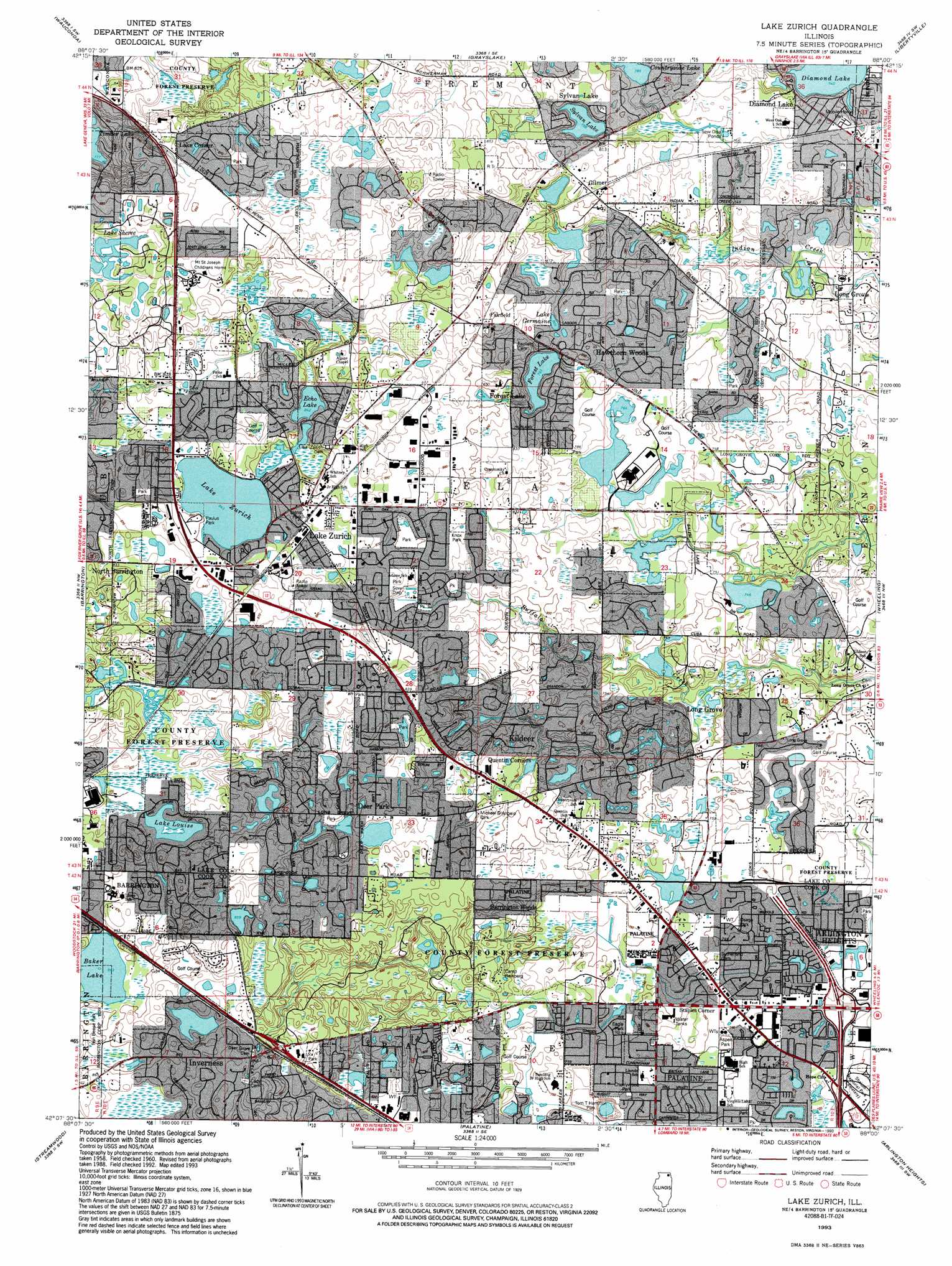
USGS Topo Quad 42088b1 - 1:24,000 scale
| Topo Map Name: | Lake Zurich |
| USGS Topo Quad ID: | 42088b1 |
| Print Size: | ca. 21 1/4" wide x 27" high |
| Southeast Coordinates: | 42.125° N latitude / 88° W longitude |
| Map Center Coordinates: | 42.1875° N latitude / 88.0625° W longitude |
| U.S. State: | IL |
| Filename: | o42088b1.jpg |
| Download Map JPG Image: | Lake Zurich topo map 1:24,000 scale |
| Map Type: | Topographic |
| Topo Series: | 7.5´ |
| Map Scale: | 1:24,000 |
| Source of Map Images: | United States Geological Survey (USGS) |
| Alternate Map Versions: |
Lake Zurich IL 1960, updated 1962 Download PDF Buy paper map Lake Zurich IL 1960, updated 1973 Download PDF Buy paper map Lake Zurich IL 1960, updated 1981 Download PDF Buy paper map Lake Zurich IL 1960, updated 1989 Download PDF Buy paper map Lake Zurich IL 1993, updated 1993 Download PDF Buy paper map Lake Zurich IL 1993, updated 1993 Download PDF Buy paper map Lake Zurich IL 1998, updated 2001 Download PDF Buy paper map Lake Zurich IL 2012 Download PDF Buy paper map Lake Zurich IL 2015 Download PDF Buy paper map |
1:24,000 Topo Quads surrounding Lake Zurich
Richmond |
Fox Lake |
Antioch |
Wadsworth |
Zion |
Mchenry |
Wauconda |
Grayslake |
Libertyville |
Waukegan |
Crystal Lake |
Barrington |
Lake Zurich |
Wheeling |
Highland Park |
Elgin |
Streamwood |
Palatine |
Arlington Heights |
Park Ridge |
Geneva |
West Chicago |
Lombard |
Elmhurst |
River Forest |
> Back to 42088a1 at 1:100,000 scale
> Back to 42088a1 at 1:250,000 scale
> Back to U.S. Topo Maps home
Lake Zurich topo map: Gazetteer
Lake Zurich: Airports
Honey Lake Heliport elevation 262m 859′Rotor Swing Heliport elevation 226m 741′
Lake Zurich: Dams
Countryside Lake Dam elevation 238m 780′Forest Lake Dam elevation 243m 797′
Sylvan Lake Dam elevation 239m 784′
Lake Zurich: Lakes
Ashley Lake elevation 261m 856′Baker Lake elevation 258m 846′
Bresen Lake elevation 239m 784′
Deer Lake elevation 260m 853′
Echo Lake elevation 258m 846′
Lake Germaine elevation 246m 807′
Lake Louise elevation 248m 813′
Lake Sheree elevation 249m 816′
Lake Zurich elevation 257m 843′
Leo Lake elevation 264m 866′
Lake Zurich: Parks
Aspen Park elevation 229m 751′Baker's Lake Nature Preserve elevation 258m 846′
Braemar Park elevation 255m 836′
Breezewald Park elevation 264m 866′
Bridlewoods Park elevation 262m 859′
Brierwood Park elevation 259m 849′
Bristol Trails Park elevation 249m 816′
Cherrywood Park elevation 230m 754′
Copperfield Park elevation 265m 869′
Countryside West Park elevation 252m 826′
Countryside West Soccer Park elevation 265m 869′
Cuba Marsh Forest Preserve elevation 250m 820′
Deer Grove Forest Preserve elevation 256m 839′
Eagle Park elevation 226m 741′
Ela Township Soccer Fields elevation 265m 869′
Heather Highlands Park elevation 254m 833′
Highview Park elevation 238m 780′
Knox Park elevation 257m 843′
Kuechmann Park elevation 261m 856′
Lake Park elevation 228m 748′
Lions Park elevation 271m 889′
Manor Park elevation 251m 823′
Michael D'Angelo Park elevation 243m 797′
Oak Ridge Marsh Nature Park elevation 258m 846′
Old Mill Grove Park elevation 258m 846′
Osage Park elevation 229m 751′
Paulus Park elevation 259m 849′
Quail Run Park elevation 264m 866′
Rambling Hills Park elevation 225m 738′
Richard E Staples Youth Sports Complex elevation 252m 826′
Ron Beese Park elevation 261m 856′
Sandlewood Park elevation 251m 823′
Sparrow Ridge Park elevation 255m 836′
Sycamore Park elevation 223m 731′
Tom T Hamilton Park elevation 230m 754′
Warwick Park elevation 243m 797′
Woodland Park elevation 236m 774′
Zurites Park elevation 262m 859′
Lake Zurich: Populated Places
Acorn Acres elevation 262m 859′Amherst elevation 264m 866′
Ancient Oaks elevation 262m 859′
Baldwin elevation 235m 770′
Barrington Woods elevation 240m 787′
Beacon Hill elevation 242m 793′
Beaver Creek elevation 234m 767′
Bishops Ridge elevation 252m 826′
Boschome elevation 238m 780′
Brentwood elevation 230m 754′
Bridlewoods elevation 262m 859′
Brierwoods elevation 259m 849′
Capri Village elevation 226m 741′
Cedar Creek elevation 253m 830′
Chapel Hill elevation 258m 846′
Copperfield elevation 271m 889′
Country Club Estates elevation 231m 757′
Countryside East elevation 260m 853′
Countryside West elevation 261m 856′
Creekside of Long Grove elevation 230m 754′
Deer Chase elevation 265m 869′
Deer Lake elevation 263m 862′
Deer Lake Meadows elevation 257m 843′
Deer Park elevation 259m 849′
Deerpath Estates elevation 264m 866′
Diamond Lake elevation 235m 770′
Dover Pond elevation 255m 836′
Echo Lake elevation 261m 856′
Elmwood elevation 266m 872′
Estates of Indian Creek elevation 229m 751′
Estates of Stone Creek elevation 265m 869′
Fairfield elevation 261m 856′
Farmington elevation 229m 751′
Ferndale Woods elevation 261m 856′
Forest Green Lake Estates elevation 253m 830′
Forest Lake elevation 248m 813′
Fox Point North elevation 254m 833′
Foxborough Estates elevation 245m 803′
Foxcroft elevation 260m 853′
Gilmer elevation 247m 810′
Hamilton Estates elevation 265m 869′
Hawthorn Knolls elevation 230m 754′
Hawthorn Woods elevation 244m 800′
Heather Highlands elevation 255m 836′
Heatherlea elevation 230m 754′
Herons Crossing elevation 237m 777′
Hickory Hills elevation 230m 754′
Hidden Lake elevation 220m 721′
Hidden Valley elevation 238m 780′
Highview elevation 242m 793′
Howe Terrace elevation 262m 859′
Indian Creek Country Estates elevation 238m 780′
Kildeer elevation 237m 777′
Knollwood elevation 255m 836′
Lake Corner elevation 261m 856′
Lake Park Estates elevation 232m 761′
Lake View Highlands elevation 245m 803′
Lake Zurich elevation 267m 875′
Lake Zurich Estates elevation 259m 849′
Lake Zurich Heights elevation 265m 869′
Lake Zurich Highlands elevation 267m 875′
Lake Zurich Manor elevation 265m 869′
Lakewood Estates elevation 266m 872′
Lochanora elevation 271m 889′
Long Grove Valley elevation 233m 764′
Marden Estates elevation 237m 777′
Meadowridge elevation 232m 761′
Oak Ridge elevation 261m 856′
Oak Ridge North elevation 263m 862′
Old Mill Grove elevation 264m 866′
Park Hill elevation 263m 862′
Pepper Tree elevation 228m 748′
Pheasant Knolls elevation 244m 800′
Pine Lake Circle elevation 241m 790′
Pine Valley elevation 248m 813′
Pinehurst Manor elevation 221m 725′
Ponds elevation 243m 797′
Prairie Creek elevation 245m 803′
Prestonfield elevation 234m 767′
Quail Run elevation 264m 866′
Quentin Corners elevation 245m 803′
Rambling Hills elevation 230m 754′
Rambling Hills East elevation 227m 744′
Rambling Hills West elevation 231m 757′
Ravens Wing elevation 259m 849′
Rue Vallee elevation 251m 823′
Squires elevation 267m 875′
Staples Corner elevation 223m 731′
Sturm Subdivision elevation 249m 816′
Swansway elevation 258m 846′
Sylvan Lake elevation 250m 820′
Tall Oaks elevation 225m 738′
Tall Trees elevation 259m 849′
The Meadows elevation 267m 875′
The Orchards elevation 255m 836′
The Woodland elevation 255m 836′
Thornfield elevation 262m 859′
Tiffany Estates elevation 231m 757′
Timber Trails elevation 269m 882′
Valentine Manor elevation 263m 862′
White Birch Lakes elevation 267m 875′
Woodland Estates elevation 235m 770′
Lake Zurich: Reservoirs
Countryside Lake elevation 238m 780′Deer Grove Lake elevation 239m 784′
Forest Lake elevation 243m 797′
Lake Naomi elevation 260m 853′
Sylvan Lake elevation 239m 784′
Virginia Lake elevation 218m 715′
Lake Zurich digital topo map on disk
Buy this Lake Zurich topo map showing relief, roads, GPS coordinates and other geographical features, as a high-resolution digital map file on DVD:
Northern Illinois, Northern Indiana & Southwestern Michigan
Buy digital topo maps: Northern Illinois, Northern Indiana & Southwestern Michigan