Huntley Topo Map Illinois
To zoom in, hover over the map of Huntley
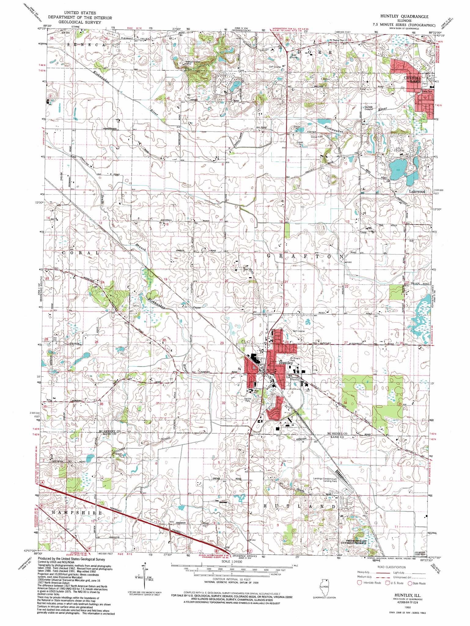
USGS Topo Quad 42088b4 - 1:24,000 scale
| Topo Map Name: | Huntley |
| USGS Topo Quad ID: | 42088b4 |
| Print Size: | ca. 21 1/4" wide x 27" high |
| Southeast Coordinates: | 42.125° N latitude / 88.375° W longitude |
| Map Center Coordinates: | 42.1875° N latitude / 88.4375° W longitude |
| U.S. State: | IL |
| Filename: | o42088b4.jpg |
| Download Map JPG Image: | Huntley topo map 1:24,000 scale |
| Map Type: | Topographic |
| Topo Series: | 7.5´ |
| Map Scale: | 1:24,000 |
| Source of Map Images: | United States Geological Survey (USGS) |
| Alternate Map Versions: |
Huntley IL 1962, updated 1964 Download PDF Buy paper map Huntley IL 1972, updated 1973 Download PDF Buy paper map Huntley IL 1978, updated 1991 Download PDF Buy paper map Huntley IL 1992, updated 1992 Download PDF Buy paper map Huntley IL 2012 Download PDF Buy paper map Huntley IL 2015 Download PDF Buy paper map |
1:24,000 Topo Quads surrounding Huntley
Capron |
Harvard |
Hebron |
Richmond |
Fox Lake |
Garden Prairie |
Marengo North |
Woodstock |
Mchenry |
Wauconda |
Riley |
Marengo South |
Huntley |
Crystal Lake |
Barrington |
Genoa |
Hampshire |
Pingree Grove |
Elgin |
Streamwood |
Sycamore |
Maple Park |
Elburn |
Geneva |
West Chicago |
> Back to 42088a1 at 1:100,000 scale
> Back to 42088a1 at 1:250,000 scale
> Back to U.S. Topo Maps home
Huntley topo map: Gazetteer
Huntley: Airports
Landings Condominium Airport elevation 269m 882′Phyllis Field elevation 261m 856′
Huntley: Dams
South Lake Dam elevation 269m 882′Huntley: Parks
Butternut Preserve elevation 272m 892′Deicke Park elevation 272m 892′
Della Park elevation 271m 889′
Freeman Kame Nature Preserve elevation 271m 889′
Freemans Kane County Forest Preserve elevation 272m 892′
Kishwaukee Fen Nature Preserve elevation 263m 862′
Ol Timers Park elevation 268m 879′
Huntley: Populated Places
Coyne elevation 266m 872′Crystal Gardens elevation 275m 902′
Huntley elevation 271m 889′
The Landings elevation 271m 889′
Huntley: Post Offices
Huntley Post Office elevation 272m 892′Huntley: Reservoirs
South Lake elevation 269m 882′Huntley: Streams
Eakin Creek South elevation 266m 872′Eakin Creek West elevation 264m 866′
Huntley: Swamps
Turnberry Wetlands elevation 263m 862′Huntley digital topo map on disk
Buy this Huntley topo map showing relief, roads, GPS coordinates and other geographical features, as a high-resolution digital map file on DVD:
Northern Illinois, Northern Indiana & Southwestern Michigan
Buy digital topo maps: Northern Illinois, Northern Indiana & Southwestern Michigan