Grayslake Topo Map Illinois
To zoom in, hover over the map of Grayslake
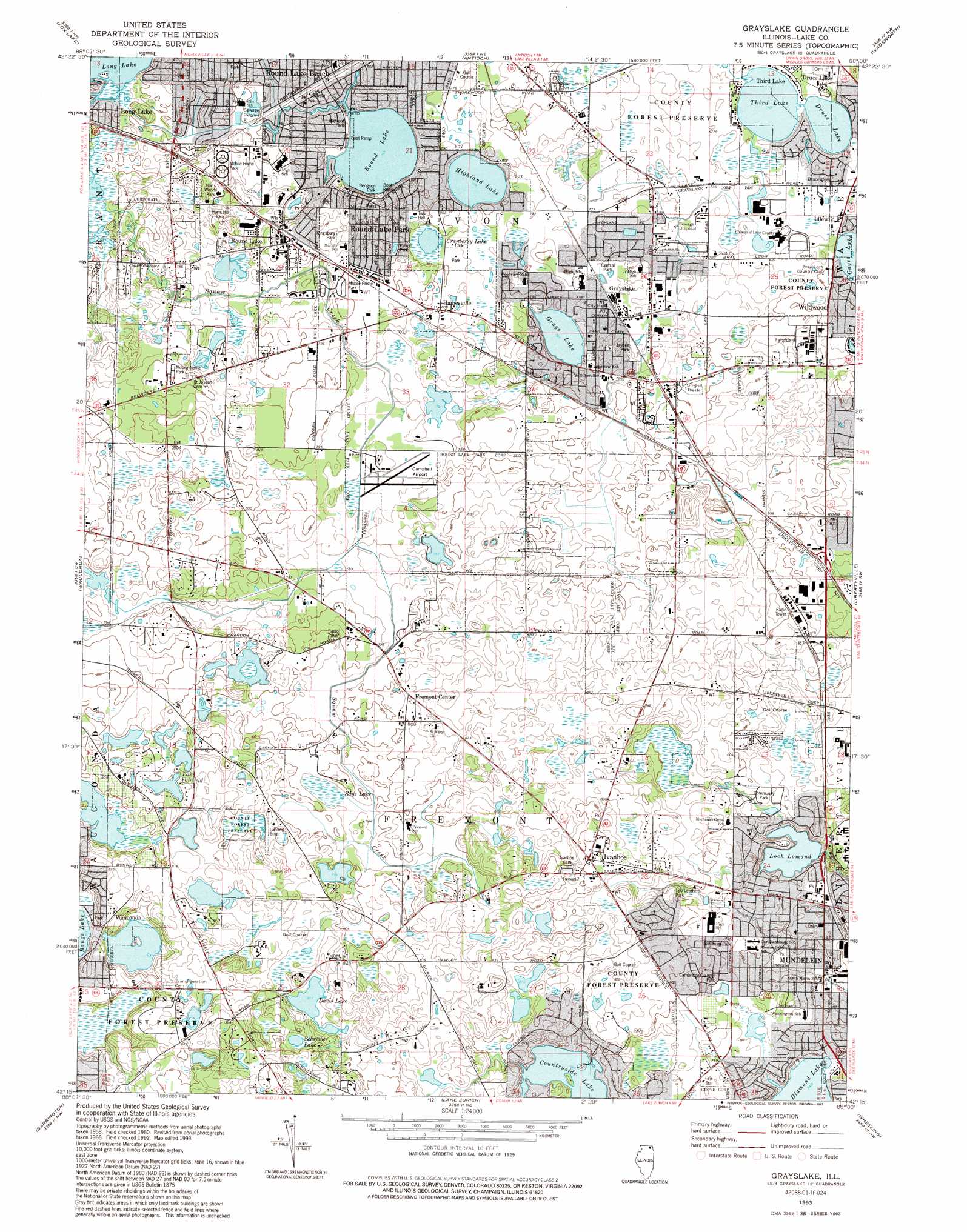
USGS Topo Quad 42088c1 - 1:24,000 scale
| Topo Map Name: | Grayslake |
| USGS Topo Quad ID: | 42088c1 |
| Print Size: | ca. 21 1/4" wide x 27" high |
| Southeast Coordinates: | 42.25° N latitude / 88° W longitude |
| Map Center Coordinates: | 42.3125° N latitude / 88.0625° W longitude |
| U.S. State: | IL |
| Filename: | o42088c1.jpg |
| Download Map JPG Image: | Grayslake topo map 1:24,000 scale |
| Map Type: | Topographic |
| Topo Series: | 7.5´ |
| Map Scale: | 1:24,000 |
| Source of Map Images: | United States Geological Survey (USGS) |
| Alternate Map Versions: |
Grayslake IL 1960, updated 1962 Download PDF Buy paper map Grayslake IL 1960, updated 1973 Download PDF Buy paper map Grayslake IL 1960, updated 1981 Download PDF Buy paper map Grayslake IL 1960, updated 1989 Download PDF Buy paper map Grayslake IL 1993, updated 1993 Download PDF Buy paper map Grayslake IL 2012 Download PDF Buy paper map Grayslake IL 2015 Download PDF Buy paper map |
1:24,000 Topo Quads surrounding Grayslake
Genoa City |
Silver Lake |
Paddock Lake |
Pleasant Prairie |
Kenosha |
Richmond |
Fox Lake |
Antioch |
Wadsworth |
Zion |
Mchenry |
Wauconda |
Grayslake |
Libertyville |
Waukegan |
Crystal Lake |
Barrington |
Lake Zurich |
Wheeling |
Highland Park |
Elgin |
Streamwood |
Palatine |
Arlington Heights |
Park Ridge |
> Back to 42088a1 at 1:100,000 scale
> Back to 42088a1 at 1:250,000 scale
> Back to U.S. Topo Maps home
Grayslake topo map: Gazetteer
Grayslake: Airports
Air Estates Inc Airport elevation 245m 803′Campbell Airport elevation 237m 777′
Rockenbach Airport elevation 241m 790′
Grayslake: Dams
Lake Amy Dam elevation 262m 859′Loch Lomond Dam elevation 225m 738′
Round Lake Dam elevation 230m 754′
Grayslake: Lakes
Countryside Lake elevation 240m 787′Cranberry Lake elevation 241m 790′
Davis Lake elevation 247m 810′
Diamond Lake elevation 227m 744′
Druce Lake elevation 234m 767′
Grays Lake elevation 240m 787′
Highland Lake elevation 236m 774′
Lake Fairfield elevation 243m 797′
Schreiber Lake elevation 255m 836′
Third Lake elevation 234m 767′
Grayslake: Parks
Bengson Park elevation 236m 774′Cambridge Country Park elevation 231m 757′
Central Park elevation 238m 780′
Community Park elevation 239m 784′
Countryside Forest Preserve elevation 251m 823′
Harts Hill Park elevation 239m 784′
Harts Woods Park elevation 238m 780′
Jaycee Park elevation 238m 780′
Kingsburg Park elevation 237m 777′
Lakefront Park elevation 235m 770′
Lakewood Forest Preserve elevation 252m 826′
Leo Leathers Park elevation 245m 803′
Parrott Park elevation 244m 800′
Sandburg Park elevation 231m 757′
Sunset Park elevation 237m 777′
Grayslake: Populated Places
Druce Lake elevation 240m 787′Fort Hill elevation 245m 803′
Fremont Center elevation 250m 820′
Grayslake elevation 239m 784′
Hainesville elevation 244m 800′
Ivanhoe elevation 258m 846′
Mundelein elevation 224m 734′
Round Lake elevation 243m 797′
Round Lake Beach elevation 233m 764′
Round Lake Park elevation 241m 790′
Third Lake elevation 235m 770′
Grayslake: Post Offices
Grayslake Post Office elevation 239m 784′Mundelein Post Office elevation 225m 738′
Grayslake: Reservoirs
Lake Amy elevation 262m 859′Loch Lomond elevation 225m 738′
Round Lake elevation 230m 754′
Grayslake: Swamps
Rays Lake elevation 239m 784′Grayslake digital topo map on disk
Buy this Grayslake topo map showing relief, roads, GPS coordinates and other geographical features, as a high-resolution digital map file on DVD:
Northern Illinois, Northern Indiana & Southwestern Michigan
Buy digital topo maps: Northern Illinois, Northern Indiana & Southwestern Michigan