Palmyra Topo Map Wisconsin
To zoom in, hover over the map of Palmyra
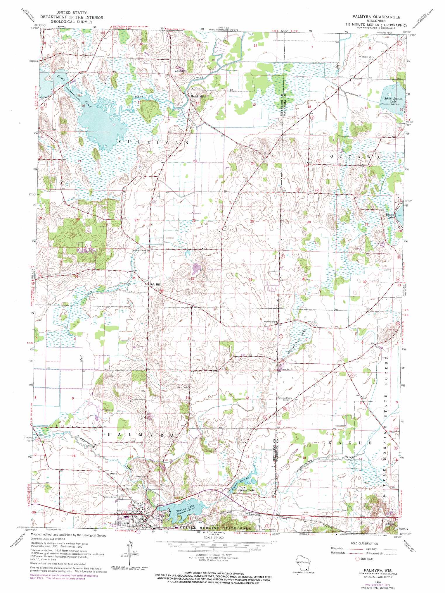
USGS Topo Quad 42088h5 - 1:24,000 scale
| Topo Map Name: | Palmyra |
| USGS Topo Quad ID: | 42088h5 |
| Print Size: | ca. 21 1/4" wide x 27" high |
| Southeast Coordinates: | 42.875° N latitude / 88.5° W longitude |
| Map Center Coordinates: | 42.9375° N latitude / 88.5625° W longitude |
| U.S. State: | WI |
| Filename: | o42088h5.jpg |
| Download Map JPG Image: | Palmyra topo map 1:24,000 scale |
| Map Type: | Topographic |
| Topo Series: | 7.5´ |
| Map Scale: | 1:24,000 |
| Source of Map Images: | United States Geological Survey (USGS) |
| Alternate Map Versions: |
Palmyra WI 1960, updated 1964 Download PDF Buy paper map Palmyra WI 1960, updated 1972 Download PDF Buy paper map Palmyra WI 1995, updated 1999 Download PDF Buy paper map Palmyra WI 2010 Download PDF Buy paper map Palmyra WI 2013 Download PDF Buy paper map Palmyra WI 2016 Download PDF Buy paper map |
1:24,000 Topo Quads surrounding Palmyra
Richwood |
Watertown |
Ixonia |
Stonebank |
Merton |
Jefferson |
Helenville |
Oconomowoc West |
Oconomowoc East |
Hartland |
Fort Atkinson |
Rome |
Palmyra |
Eagle |
Genesee |
Lima Center |
Whitewater |
Little Prairie |
East Troy |
Mukwonago |
Avalon |
Delavan |
Elkhorn |
Springfield |
Burlington |
> Back to 42088e1 at 1:100,000 scale
> Back to 42088a1 at 1:250,000 scale
> Back to U.S. Topo Maps home
Palmyra topo map: Gazetteer
Palmyra: Airports
Palmyra Municipal Airport elevation 259m 849′Palmyra: Dams
Carlin Dam elevation 259m 849′School Section Lake 2WP284 Dam elevation 261m 856′
Spring Lake E18.2 Dam elevation 249m 816′
Palmyra: Lakes
Beaver Dam Lake elevation 263m 862′Palmyra: Parks
Scuppernong Prairie State Natural Area elevation 257m 843′Palmyra: Populated Places
Heath Mills elevation 259m 849′Oak Hill elevation 250m 820′
Palmyra elevation 259m 849′
Palmyra: Reservoirs
School Section Lake elevation 261m 856′School Section Lake 2 elevation 260m 853′
Spring Lake elevation 249m 816′
Spring Lake 38 elevation 249m 816′
Upper Spring Lake elevation 254m 833′
Upper Spring Lake 35 elevation 259m 849′
Palmyra digital topo map on disk
Buy this Palmyra topo map showing relief, roads, GPS coordinates and other geographical features, as a high-resolution digital map file on DVD:
Northern Illinois, Northern Indiana & Southwestern Michigan
Buy digital topo maps: Northern Illinois, Northern Indiana & Southwestern Michigan