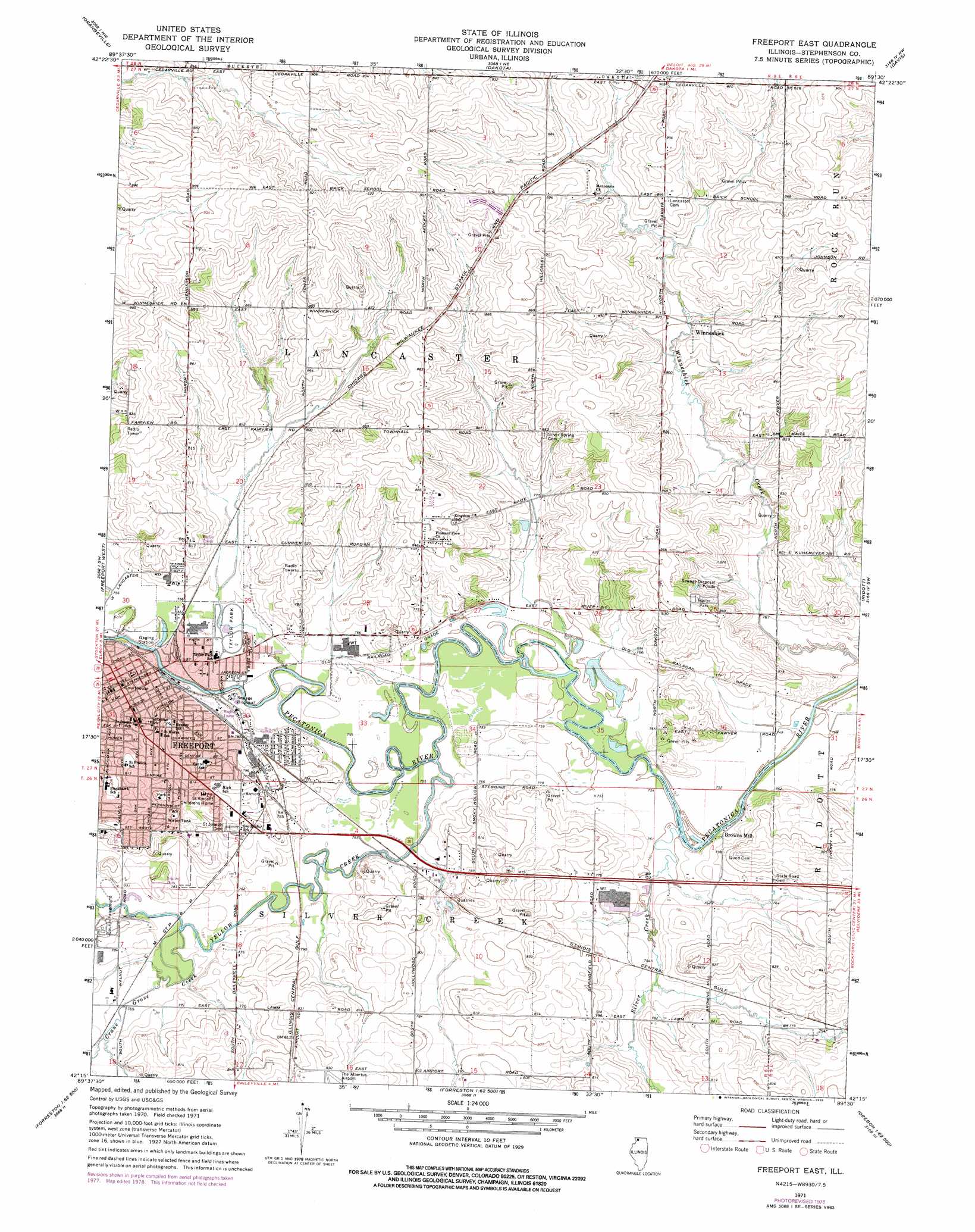
Freeport East Topo Map Illinois
To zoom in, hover over the map of Freeport East
USGS Topo Quad 42089c5 - 1:24,000 scale
| Topo Map Name: | Freeport East |
| USGS Topo Quad ID: | 42089c5 |
| Print Size: | ca. 21 1/4" wide x 27" high |
| Southeast Coordinates: | 42.25° N latitude / 89.5° W longitude |
| Map Center Coordinates: | 42.3125° N latitude / 89.5625° W longitude |
| U.S. State: | IL |
| Filename: | o42089c5.jpg |
| Download Map JPG Image: | Freeport East topo map 1:24,000 scale |
| Map Type: | Topographic |
| Topo Series: | 7.5´ |
| Map Scale: | 1:24,000 |
| Source of Map Images: | United States Geological Survey (USGS) |
| Alternate Map Versions: |
Freeport East IL 1971, updated 1974 Download PDF Buy paper map Freeport East IL 1971, updated 1978 Download PDF Buy paper map Freeport East IL 2012 Download PDF Buy paper map Freeport East IL 2015 Download PDF Buy paper map |
1:24,000 Topo Quads surrounding Freeport East
Browntown |
Monroe |
Juda |
Brodhead West |
Brodhead East |
Lena |
Orangeville |
Dakota |
Davis |
Durand |
Pearl City |
Freeport West |
Freeport East |
Ridott |
Pecatonica |
Boone Branch |
Shannon |
Forreston North |
German Valley |
Seward |
Lanark |
Brookville |
Forreston South |
Mount Morris |
Oregon |
> Back to 42089a1 at 1:100,000 scale
> Back to 42088a1 at 1:250,000 scale
> Back to U.S. Topo Maps home
Freeport East topo map: Gazetteer
Freeport East: Airports
Franzmeir Field elevation 252m 826′Freeport East: Mines
Brownsmill Quarry elevation 251m 823′Dwyer Quarry elevation 234m 767′
Fairview Quarry elevation 248m 813′
Neiman Quarry elevation 245m 803′
Schoonhoven Quarry elevation 273m 895′
Freeport East: Parks
Freeport Prairie Nature Preserve elevation 245m 803′Stephenson County Fairgrounds elevation 239m 784′
Taylor Park elevation 231m 757′
Third Ward Park elevation 248m 813′
Freeport East: Populated Places
Browns Mill elevation 230m 754′Freeport elevation 237m 777′
Valley Creek (historical) elevation 245m 803′
Winneshiek elevation 252m 826′
Freeport East: Post Offices
Freeport Post Office elevation 237m 777′Freeport East: Streams
Crane Grove Creek elevation 232m 761′Silver Creek elevation 228m 748′
Yellow Creek elevation 228m 748′
Freeport East digital topo map on disk
Buy this Freeport East topo map showing relief, roads, GPS coordinates and other geographical features, as a high-resolution digital map file on DVD:
Northern Illinois, Northern Indiana & Southwestern Michigan
Buy digital topo maps: Northern Illinois, Northern Indiana & Southwestern Michigan