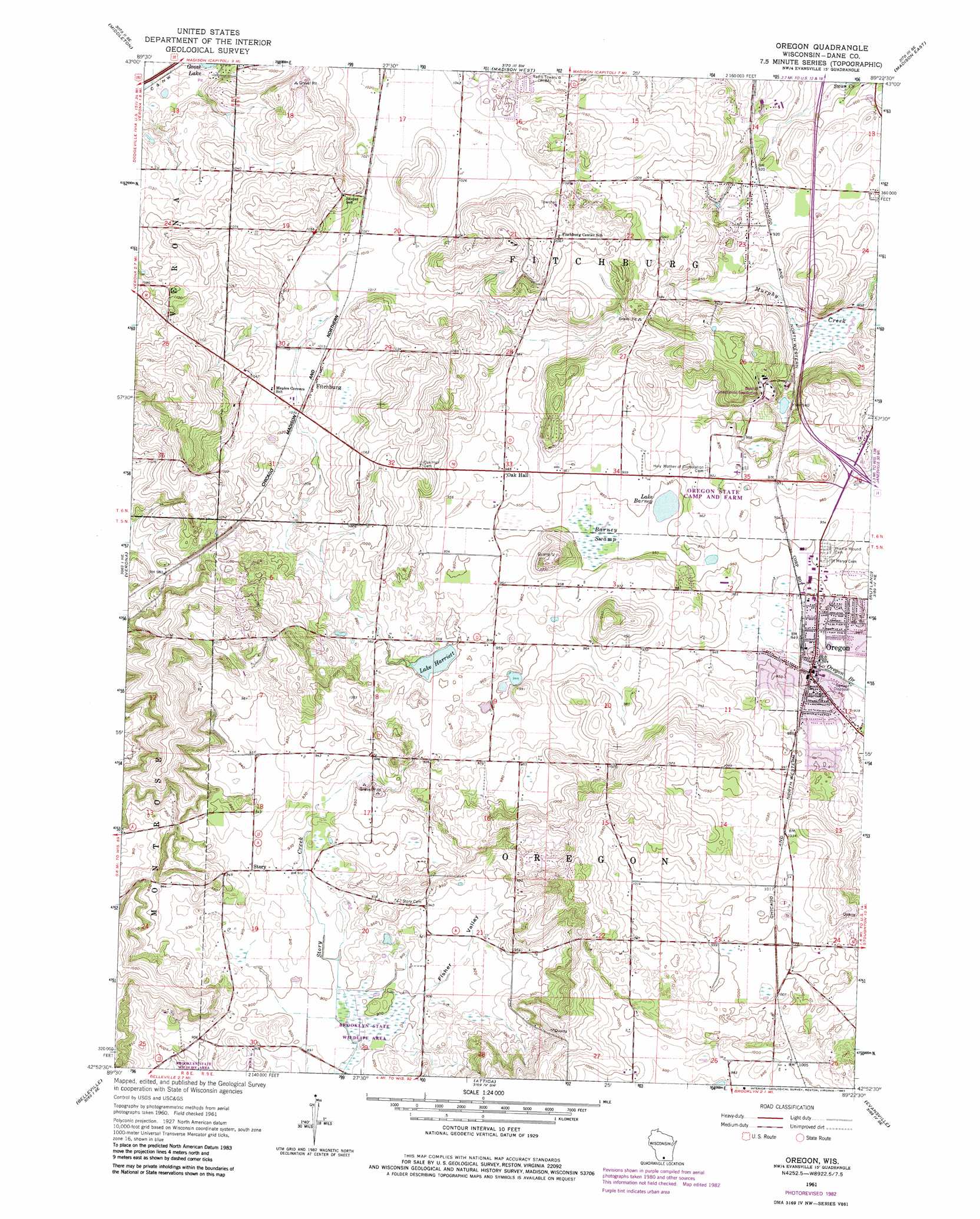
Oregon Topo Map Wisconsin
To zoom in, hover over the map of Oregon
USGS Topo Quad 42089h4 - 1:24,000 scale
| Topo Map Name: | Oregon |
| USGS Topo Quad ID: | 42089h4 |
| Print Size: | ca. 21 1/4" wide x 27" high |
| Southeast Coordinates: | 42.875° N latitude / 89.375° W longitude |
| Map Center Coordinates: | 42.9375° N latitude / 89.4375° W longitude |
| U.S. State: | WI |
| Filename: | o42089h4.jpg |
| Download Map JPG Image: | Oregon topo map 1:24,000 scale |
| Map Type: | Topographic |
| Topo Series: | 7.5´ |
| Map Scale: | 1:24,000 |
| Source of Map Images: | United States Geological Survey (USGS) |
| Alternate Map Versions: |
Oregon WI 1961, updated 1964 Download PDF Buy paper map Oregon WI 1961, updated 1970 Download PDF Buy paper map Oregon WI 1961, updated 1977 Download PDF Buy paper map Oregon WI 1961, updated 1983 Download PDF Buy paper map Oregon WI 2010 Download PDF Buy paper map Oregon WI 2013 Download PDF Buy paper map Oregon WI 2016 Download PDF Buy paper map |
1:24,000 Topo Quads surrounding Oregon
Black Earth |
Springfield Corners |
Waunakee |
De Forest |
Sun Prairie |
Cross Plains |
Middleton |
Madison West |
Madison East |
Cottage Grove |
Mount Vernon |
Verona |
Oregon |
Rutland |
Stoughton |
New Glarus |
Belleville |
Attica |
Evansville |
Cooksville |
Monroe Nw |
Monticello |
Albany |
Orfordville |
Footville |
> Back to 42089e1 at 1:100,000 scale
> Back to 42088a1 at 1:250,000 scale
> Back to U.S. Topo Maps home
Oregon topo map: Gazetteer
Oregon: Airports
Brooklyn Field elevation 307m 1007′Peterson Field elevation 298m 977′
Weiman Airport elevation 300m 984′
Oregon: Lakes
Lake Barney elevation 288m 944′Lake Harriett elevation 288m 944′
Oregon: Populated Places
Fitchburg elevation 310m 1017′Oak Hall elevation 295m 967′
Oregon elevation 288m 944′
Oregon: Post Offices
Oregon Post Office elevation 286m 938′Oregon: Swamps
Barney Swamp elevation 289m 948′Oregon: Valleys
Fisher Valley elevation 276m 905′Oregon digital topo map on disk
Buy this Oregon topo map showing relief, roads, GPS coordinates and other geographical features, as a high-resolution digital map file on DVD:
Northern Illinois, Northern Indiana & Southwestern Michigan
Buy digital topo maps: Northern Illinois, Northern Indiana & Southwestern Michigan