Maquoketa Topo Map Iowa
To zoom in, hover over the map of Maquoketa
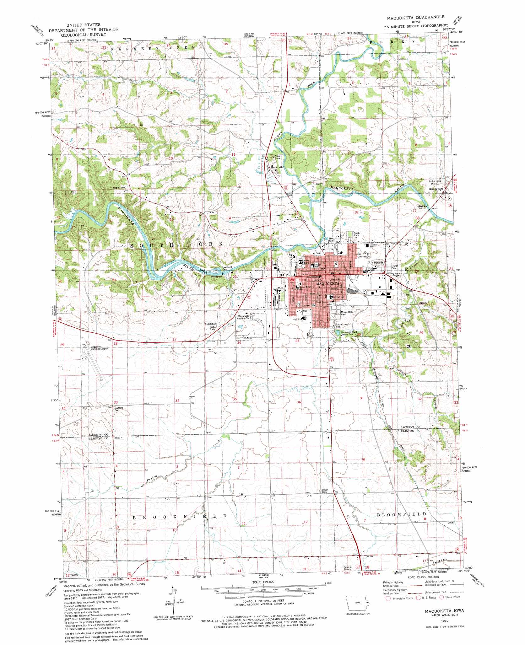
USGS Topo Quad 42090a6 - 1:24,000 scale
| Topo Map Name: | Maquoketa |
| USGS Topo Quad ID: | 42090a6 |
| Print Size: | ca. 21 1/4" wide x 27" high |
| Southeast Coordinates: | 42° N latitude / 90.625° W longitude |
| Map Center Coordinates: | 42.0625° N latitude / 90.6875° W longitude |
| U.S. State: | IA |
| Filename: | o42090a6.jpg |
| Download Map JPG Image: | Maquoketa topo map 1:24,000 scale |
| Map Type: | Topographic |
| Topo Series: | 7.5´ |
| Map Scale: | 1:24,000 |
| Source of Map Images: | United States Geological Survey (USGS) |
| Alternate Map Versions: |
Maquoketa IA 1980, updated 1981 Download PDF Buy paper map Maquoketa IA 2010 Download PDF Buy paper map Maquoketa IA 2013 Download PDF Buy paper map Maquoketa IA 2015 Download PDF Buy paper map |
1:24,000 Topo Quads surrounding Maquoketa
Fillmore |
Bernard |
Zwingle |
La Motte |
Bellevue |
Canton |
Leisure Lake |
Fulton |
Andrew |
Springbrook |
Wyoming East |
Baldwin |
Maquoketa |
Delmar North |
Preston |
Oxford Junction |
Lost Nation |
Elwood |
Delmar South |
Goose Lake |
Lowden |
Wheatland |
Grand Mound |
De Witt |
Malone |
> Back to 42090a1 at 1:100,000 scale
> Back to 42090a1 at 1:250,000 scale
> Back to U.S. Topo Maps home
Maquoketa topo map: Gazetteer
Maquoketa: Airports
Maquoketa Municipal Airport elevation 229m 751′Maquoketa: Dams
Lakehurst Dam elevation 203m 666′Maquoketa: Parks
Bi-Centennial Park elevation 206m 675′Black Hawk Wildlife Area elevation 212m 695′
Brookfield Wildlife Refuge elevation 224m 734′
City Ball Park elevation 204m 669′
Crawford Park elevation 212m 695′
Fifth Ward Park elevation 221m 725′
First Ward Park elevation 214m 702′
Horseshoe Pond County Park elevation 206m 675′
Little Bear Park elevation 208m 682′
Meadowbrook II Playground elevation 219m 718′
Third Ward Park elevation 228m 748′
Maquoketa: Populated Places
Bridgeport elevation 209m 685′Hurstville elevation 202m 662′
Maquoketa elevation 214m 702′
Maquoketa: Post Offices
Bridgeport Post Office (historical) elevation 209m 685′Hurstville Post Office (historical) elevation 202m 662′
Maquoketa Post Office elevation 210m 688′
Maquoketa: Streams
Elwood Creek elevation 209m 685′Hurstville Branch elevation 199m 652′
Hurstville Branch elevation 200m 656′
North Fork Maquoketa River elevation 200m 656′
Prairie Creek elevation 195m 639′
Pumpkin Creek elevation 209m 685′
Silver Creek elevation 201m 659′
Union Creek elevation 206m 675′
Maquoketa digital topo map on disk
Buy this Maquoketa topo map showing relief, roads, GPS coordinates and other geographical features, as a high-resolution digital map file on DVD: