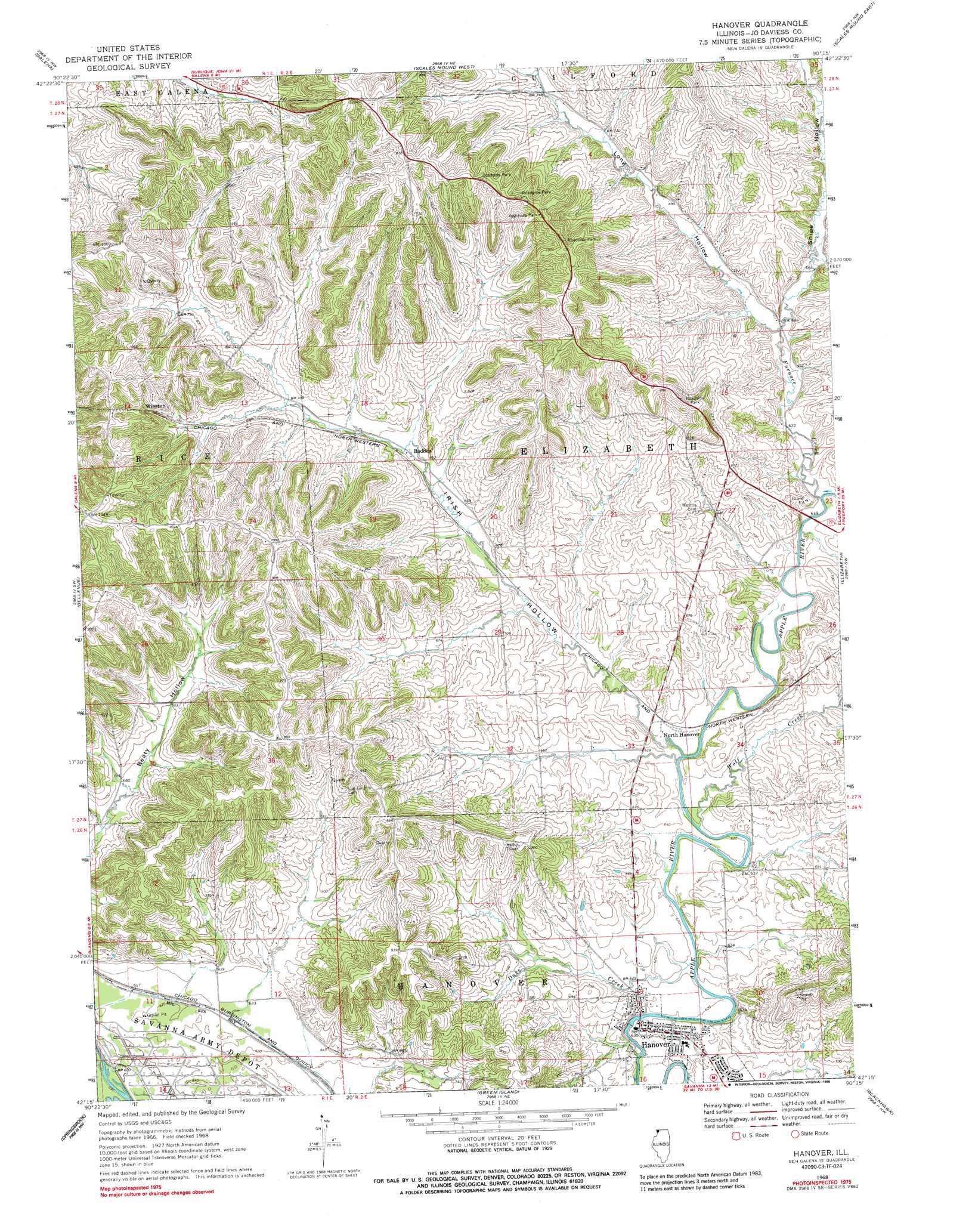
Hanover Topo Map Illinois
To zoom in, hover over the map of Hanover
USGS Topo Quad 42090c3 - 1:24,000 scale
| Topo Map Name: | Hanover |
| USGS Topo Quad ID: | 42090c3 |
| Print Size: | ca. 21 1/4" wide x 27" high |
| Southeast Coordinates: | 42.25° N latitude / 90.25° W longitude |
| Map Center Coordinates: | 42.3125° N latitude / 90.3125° W longitude |
| U.S. State: | IL |
| Filename: | o42090c3.jpg |
| Download Map JPG Image: | Hanover topo map 1:24,000 scale |
| Map Type: | Topographic |
| Topo Series: | 7.5´ |
| Map Scale: | 1:24,000 |
| Source of Map Images: | United States Geological Survey (USGS) |
| Alternate Map Versions: |
Hanover IL 1968, updated 1970 Download PDF Buy paper map Hanover IL 1968, updated 1988 Download PDF Buy paper map Hanover IL 1968, updated 1988 Download PDF Buy paper map Hanover IL 2012 Download PDF Buy paper map Hanover IL 2015 Download PDF Buy paper map |
1:24,000 Topo Quads surrounding Hanover
Kieler |
Cuba City |
New Diggings |
Shullsburg |
Apple River |
Menominee |
Galena |
Scales Mound West |
Scales Mound East |
Elizabeth Ne |
La Motte |
Bellevue |
Hanover |
Elizabeth |
Stockton |
Andrew |
Springbrook |
Green Island |
Blackhawk |
Pleasant Valley |
Delmar North |
Preston |
Miles |
Savanna |
Wacker |
> Back to 42090a1 at 1:100,000 scale
> Back to 42090a1 at 1:250,000 scale
> Back to U.S. Topo Maps home
Hanover topo map: Gazetteer
Hanover: Airports
Merkle Engineers Airport elevation 298m 977′Hanover: Parks
Tapley Woods Conservation Area elevation 300m 984′Hanover: Populated Places
Hanover elevation 194m 636′North Hanover elevation 193m 633′
Rodden elevation 205m 672′
Weston (historical) elevation 193m 633′
Winston elevation 248m 813′
Hanover: Post Offices
Avery Post Office (historical) elevation 225m 738′Hanover: Streams
Duke Creek elevation 189m 620′Furnace Creek elevation 189m 620′
Irish Hollow Creek elevation 189m 620′
Long Hollow Creek elevation 194m 636′
Wolf Creek elevation 189m 620′
Hanover: Valleys
Irish Hollow elevation 192m 629′Long Hollow elevation 194m 636′
Snipe Hollow elevation 194m 636′
Hanover digital topo map on disk
Buy this Hanover topo map showing relief, roads, GPS coordinates and other geographical features, as a high-resolution digital map file on DVD: