Sherrill Topo Map Iowa
To zoom in, hover over the map of Sherrill
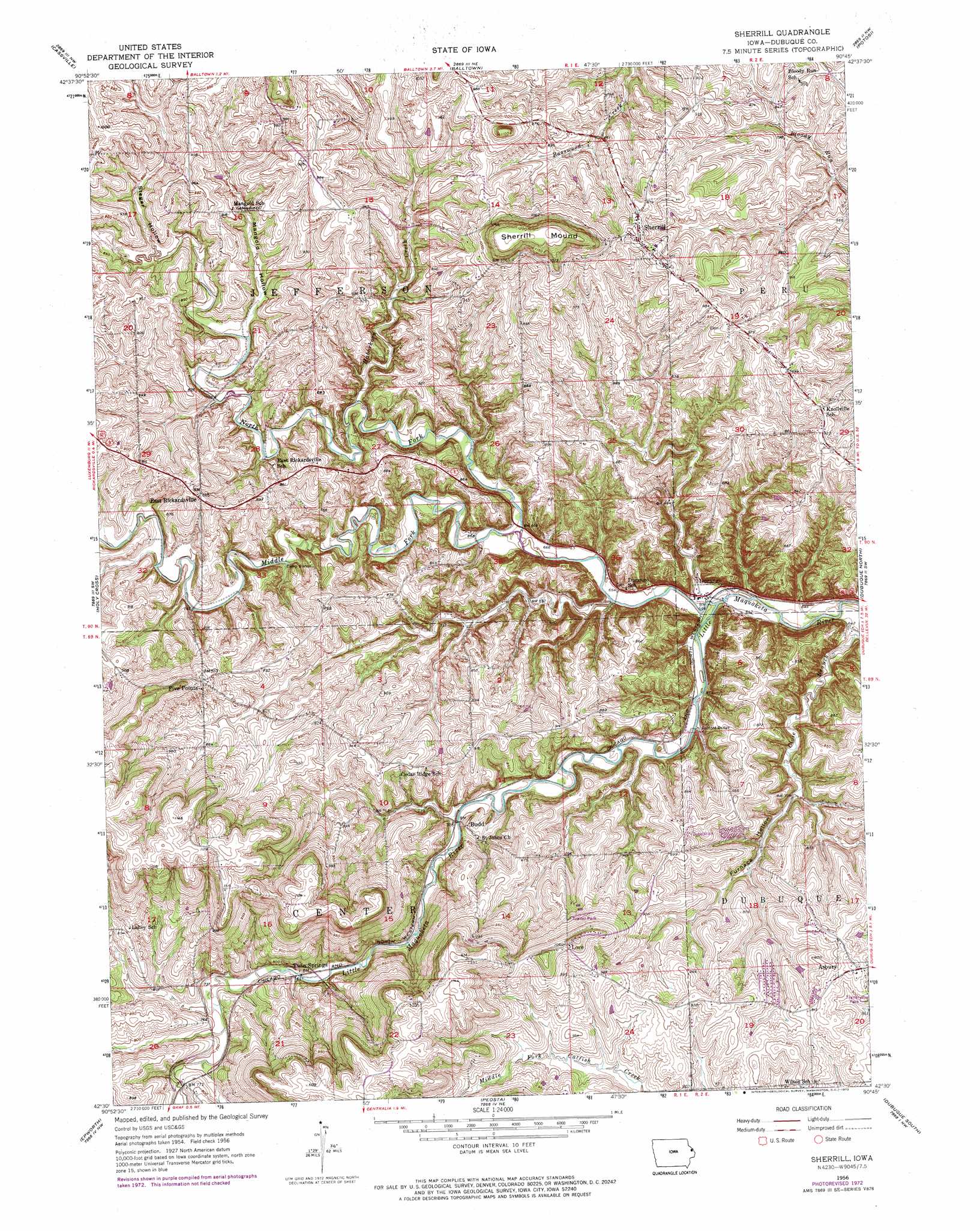
USGS Topo Quad 42090e7 - 1:24,000 scale
| Topo Map Name: | Sherrill |
| USGS Topo Quad ID: | 42090e7 |
| Print Size: | ca. 21 1/4" wide x 27" high |
| Southeast Coordinates: | 42.5° N latitude / 90.75° W longitude |
| Map Center Coordinates: | 42.5625° N latitude / 90.8125° W longitude |
| U.S. State: | IA |
| Filename: | o42090e7.jpg |
| Download Map JPG Image: | Sherrill topo map 1:24,000 scale |
| Map Type: | Topographic |
| Topo Series: | 7.5´ |
| Map Scale: | 1:24,000 |
| Source of Map Images: | United States Geological Survey (USGS) |
| Alternate Map Versions: |
Sherrill IA 1956, updated 1958 Download PDF Buy paper map Sherrill IA 1956, updated 1973 Download PDF Buy paper map Sherrill IA 2010 Download PDF Buy paper map Sherrill IA 2013 Download PDF Buy paper map Sherrill IA 2015 Download PDF Buy paper map |
1:24,000 Topo Quads surrounding Sherrill
Guttenberg |
Beetown |
Hurricane |
Lancaster |
Ellenboro |
Turkey River |
Cassville |
Balltown |
Potosi |
Dickeyville |
New Vienna |
Holy Cross |
Sherrill |
Dubuque North |
Kieler |
Dyersville East |
Epworth |
Peosta |
Dubuque South |
Menominee |
Cascade |
Fillmore |
Bernard |
Zwingle |
La Motte |
> Back to 42090e1 at 1:100,000 scale
> Back to 42090a1 at 1:250,000 scale
> Back to U.S. Topo Maps home
Sherrill topo map: Gazetteer
Sherrill: Bridges
Rodford Bridge elevation 198m 649′Sherrill: Populated Places
Asbury elevation 284m 931′Budd elevation 231m 757′
Durango elevation 196m 643′
East Rickardsville elevation 273m 895′
Five Points elevation 300m 984′
Lore elevation 323m 1059′
Lore Mobile Home Park elevation 287m 941′
Sherrill elevation 299m 980′
Twin Springs elevation 222m 728′
Sherrill: Post Offices
Asbury Post Office (historical) elevation 284m 931′Durango Post Office (historical) elevation 196m 643′
Lore Post Office (historical) elevation 323m 1059′
Sherrill POst Office elevation 299m 980′
Sherrill: Streams
Haberkorn Creek elevation 213m 698′Middle Fork Little Maquoketa River elevation 199m 652′
North Fork Little Maquoketa River elevation 192m 629′
Sherrill: Summits
Sherrill Mound elevation 374m 1227′Sherrill: Valleys
Furnace Hollow elevation 193m 633′Mangold Hollow elevation 237m 777′
Stegar Hollow elevation 243m 797′
Sherrill digital topo map on disk
Buy this Sherrill topo map showing relief, roads, GPS coordinates and other geographical features, as a high-resolution digital map file on DVD: