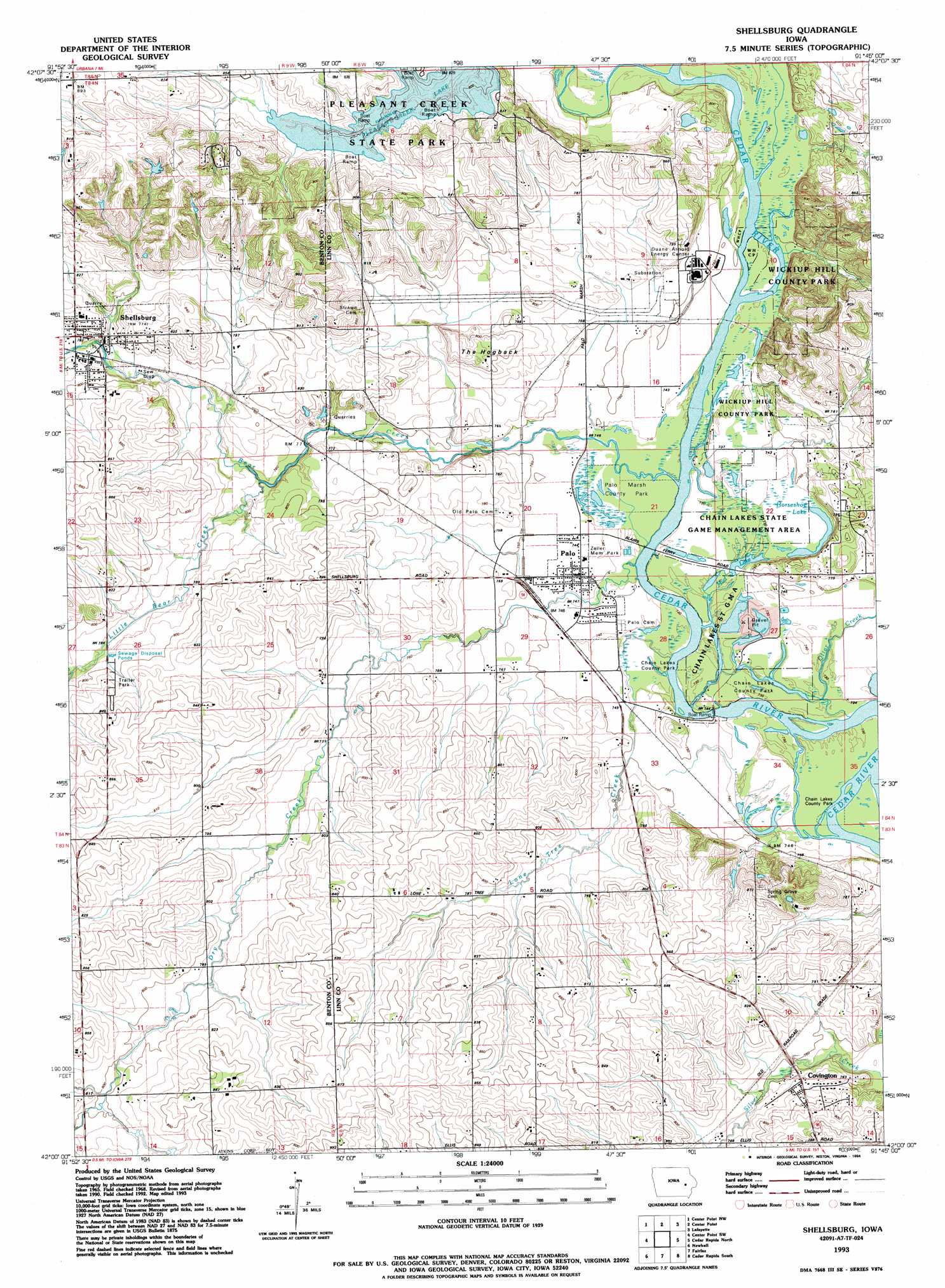
Shellsburg Topo Map Iowa
To zoom in, hover over the map of Shellsburg
USGS Topo Quad 42091a7 - 1:24,000 scale
| Topo Map Name: | Shellsburg |
| USGS Topo Quad ID: | 42091a7 |
| Print Size: | ca. 21 1/4" wide x 27" high |
| Southeast Coordinates: | 42° N latitude / 91.75° W longitude |
| Map Center Coordinates: | 42.0625° N latitude / 91.8125° W longitude |
| U.S. State: | IA |
| Filename: | o42091a7.jpg |
| Download Map JPG Image: | Shellsburg topo map 1:24,000 scale |
| Map Type: | Topographic |
| Topo Series: | 7.5´ |
| Map Scale: | 1:24,000 |
| Source of Map Images: | United States Geological Survey (USGS) |
| Alternate Map Versions: |
Shellsburg IA 1968, updated 1971 Download PDF Buy paper map Shellsburg IA 1968, updated 1976 Download PDF Buy paper map Shellsburg IA 1968, updated 1983 Download PDF Buy paper map Shellsburg IA 1993, updated 1994 Download PDF Buy paper map Shellsburg IA 2010 Download PDF Buy paper map Shellsburg IA 2013 Download PDF Buy paper map Shellsburg IA 2015 Download PDF Buy paper map |
1:24,000 Topo Quads surrounding Shellsburg
Brandon |
Cheney |
Walker |
Troy Mills |
Coggon |
Vinton |
Center Point Nw |
Center Point |
Lafayette |
Central City |
Van Horne |
Center Point Sw |
Shellsburg |
Cedar Rapids North |
Marion |
Blairstown |
Newhall |
Fairfax |
Cedar Rapids South |
Bertram |
Marengo |
Middle Amana |
Amana |
Swisher |
Ely |
> Back to 42091a1 at 1:100,000 scale
> Back to 42090a1 at 1:250,000 scale
> Back to U.S. Topo Maps home
Shellsburg topo map: Gazetteer
Shellsburg: Airports
DAEC Helipad elevation 230m 754′Shellsburg: Bridges
Chain Lakes Bridge elevation 219m 718′Shellsburg Bridge elevation 235m 770′
Shellsburg: Lakes
Mud Lake elevation 222m 728′Shellsburg: Parks
Chain Lakes County Park elevation 222m 728′Chain-O-Lakes Wildlife Management Area elevation 222m 728′
Hanging Bog State Preserve elevation 222m 728′
Palo Marsh County Park elevation 224m 734′
Pleasant Creek State Park elevation 250m 820′
Wickup Hill County Park elevation 235m 770′
Zeller Memorial Park elevation 226m 741′
Shellsburg: Populated Places
Covington elevation 239m 784′Palo elevation 226m 741′
Shellsburg elevation 241m 790′
Shellsburg: Post Offices
Covington Post Office (historical) elevation 239m 784′Oak Grove Post Office (historical) elevation 252m 826′
Palo Post Office elevation 226m 741′
Shellsburg Post Office elevation 240m 787′
Shellsburg: Streams
Bear Creek elevation 219m 718′Dry Creek elevation 219m 718′
Little Bear Creek elevation 228m 748′
Lone Tree Creek elevation 219m 718′
Otter Creek elevation 223m 731′
Shellsburg: Summits
The Hogback elevation 251m 823′Shellsburg digital topo map on disk
Buy this Shellsburg topo map showing relief, roads, GPS coordinates and other geographical features, as a high-resolution digital map file on DVD: