Marshalltown Topo Map Iowa
To zoom in, hover over the map of Marshalltown
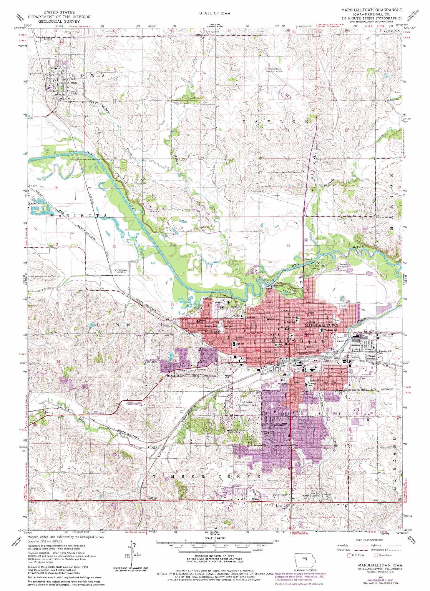
USGS Topo Quad 42092a8 - 1:24,000 scale
| Topo Map Name: | Marshalltown |
| USGS Topo Quad ID: | 42092a8 |
| Print Size: | ca. 21 1/4" wide x 27" high |
| Southeast Coordinates: | 42° N latitude / 92.875° W longitude |
| Map Center Coordinates: | 42.0625° N latitude / 92.9375° W longitude |
| U.S. State: | IA |
| Filename: | o42092a8.jpg |
| Download Map JPG Image: | Marshalltown topo map 1:24,000 scale |
| Map Type: | Topographic |
| Topo Series: | 7.5´ |
| Map Scale: | 1:24,000 |
| Source of Map Images: | United States Geological Survey (USGS) |
| Alternate Map Versions: |
Marshalltown IA 1960, updated 1962 Download PDF Buy paper map Marshalltown IA 1960, updated 1980 Download PDF Buy paper map Marshalltown IA 2010 Download PDF Buy paper map Marshalltown IA 2013 Download PDF Buy paper map Marshalltown IA 2015 Download PDF Buy paper map |
1:24,000 Topo Quads surrounding Marshalltown
New Providence |
Eldora |
Ivester |
Grundy Center |
Lincoln |
State Center Nw |
Union |
Conrad West |
Conrad East |
Gladbrook |
State Center |
La Moille |
Marshalltown |
Le Grand |
Garwin |
Rhodes |
Melbourne |
Laurel |
Gilman |
Montour |
Baxter |
Baxter Se |
Alloway Creek |
Newburg |
Grinnell North |
> Back to 42092a1 at 1:100,000 scale
> Back to 42092a1 at 1:250,000 scale
> Back to U.S. Topo Maps home
Marshalltown topo map: Gazetteer
Marshalltown: Airports
Marshalltown Municipal Airport elevation 296m 971′Marshalltown: Parks
Anson Park elevation 273m 895′Arnold Park elevation 283m 928′
Assistance League Park elevation 282m 925′
B P W Park elevation 268m 879′
French Park elevation 270m 885′
Jaycees Park elevation 305m 1000′
Kiwanis Park elevation 298m 977′
Legion Memorial Park elevation 285m 935′
Morris Park elevation 271m 889′
Optimist Park elevation 270m 885′
Peterson Park elevation 270m 885′
Riverview Park elevation 263m 862′
Site of First Log Cabin in Marshalltown Historical Marker elevation 284m 931′
Susie Sower Park elevation 286m 938′
Tankersly Park elevation 272m 892′
Timber Creek Park elevation 279m 915′
Marshalltown: Populated Places
Albion elevation 292m 958′Marshalltown elevation 287m 941′
Starlite Mobile Home Park elevation 302m 990′
Sunset Village Mobile Home Park elevation 302m 990′
Marshalltown: Post Offices
Albion Post Office elevation 292m 958′Marshalltown Post Office elevation 284m 931′
Marshalltown: Streams
Anson Creek elevation 265m 869′Asher Creek elevation 262m 859′
Burnett Creek elevation 262m 859′
Chicken Creek elevation 268m 879′
Marshalltown: Trails
Linn Creek Greenbelt elevation 266m 872′Marshalltown digital topo map on disk
Buy this Marshalltown topo map showing relief, roads, GPS coordinates and other geographical features, as a high-resolution digital map file on DVD: