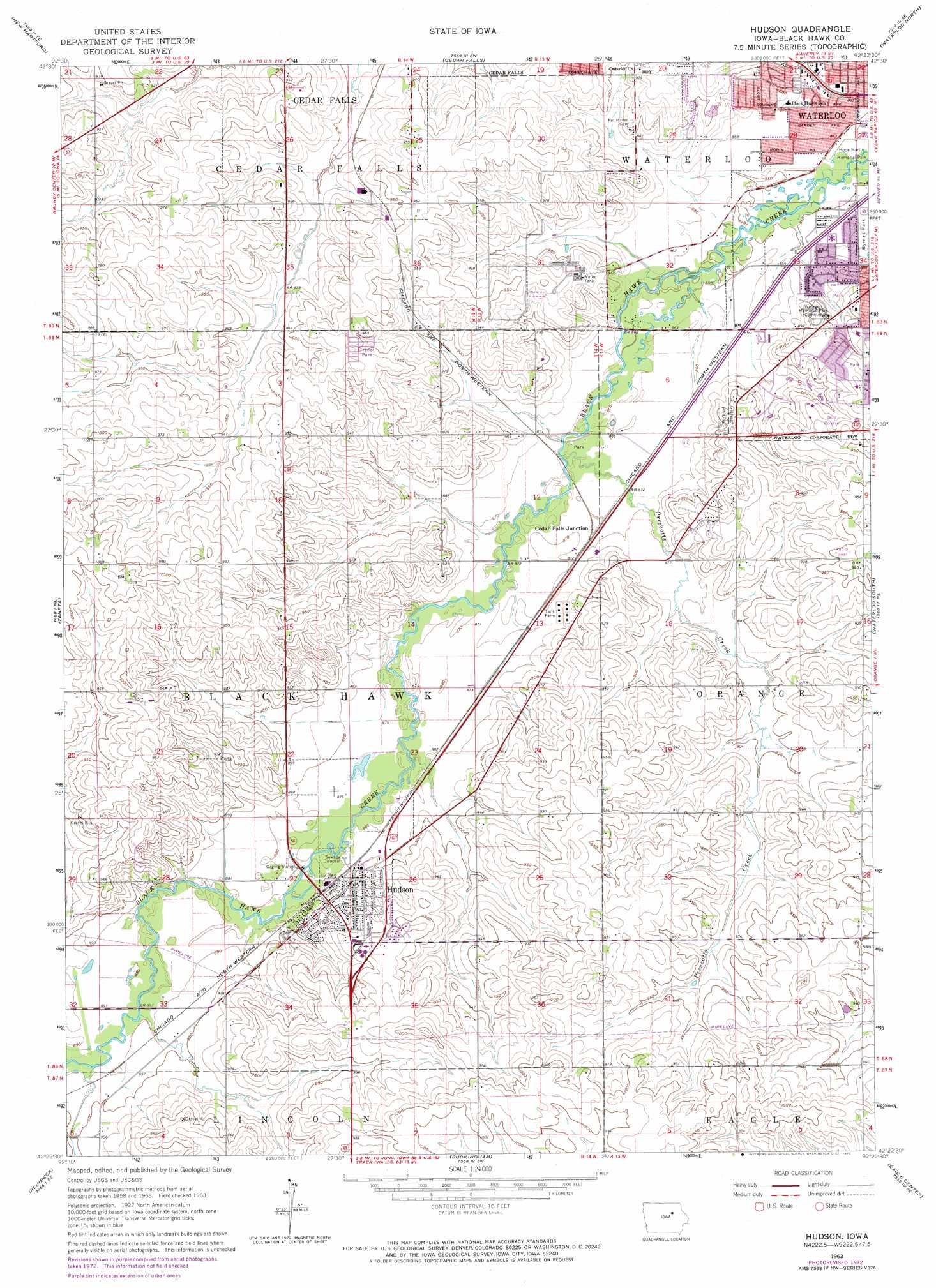
Hudson Topo Map Iowa
To zoom in, hover over the map of Hudson
USGS Topo Quad 42092d4 - 1:24,000 scale
| Topo Map Name: | Hudson |
| USGS Topo Quad ID: | 42092d4 |
| Print Size: | ca. 21 1/4" wide x 27" high |
| Southeast Coordinates: | 42.375° N latitude / 92.375° W longitude |
| Map Center Coordinates: | 42.4375° N latitude / 92.4375° W longitude |
| U.S. State: | IA |
| Filename: | o42092d4.jpg |
| Download Map JPG Image: | Hudson topo map 1:24,000 scale |
| Map Type: | Topographic |
| Topo Series: | 7.5´ |
| Map Scale: | 1:24,000 |
| Source of Map Images: | United States Geological Survey (USGS) |
| Alternate Map Versions: |
Hudson IA 1963, updated 1964 Download PDF Buy paper map Hudson IA 1963, updated 1973 Download PDF Buy paper map Hudson IA 2010 Download PDF Buy paper map Hudson IA 2013 Download PDF Buy paper map Hudson IA 2015 Download PDF Buy paper map |
1:24,000 Topo Quads surrounding Hudson
Coster |
Shell Rock |
Waverly |
Denver |
Readlyn |
Stout |
New Hartford |
Cedar Falls |
Waterloo North |
Dunkerton |
Dike |
Zaneta |
Hudson |
Waterloo South |
Gilbertville |
Lincoln |
Reinbeck |
Buckingham |
Eagle Center |
La Porte City |
Gladbrook |
Gladbrook Ne |
Traer |
Dysart |
Garrison |
> Back to 42092a1 at 1:100,000 scale
> Back to 42092a1 at 1:250,000 scale
> Back to U.S. Topo Maps home
Hudson topo map: Gazetteer
Hudson: Airports
Witcombe Field elevation 295m 967′Hudson: Parks
Black Hawk Creek Greenbelt elevation 265m 869′Byron Sergeant Memorial Park elevation 268m 879′
Devonshire Park elevation 268m 879′
Eldorado Heights Park elevation 271m 889′
Franke Park elevation 268m 879′
Freedom Park elevation 288m 944′
Greenhill Park elevation 288m 944′
Historic Black Hawk County State Historical Marker elevation 268m 879′
Hudson Park elevation 286m 938′
Miriams Park elevation 277m 908′
Prairie Grove Park elevation 273m 895′
Prairie Lakes Park elevation 286m 938′
Robinson Bird Sanctuary elevation 262m 859′
Sulentic Park elevation 280m 918′
Witry Field elevation 271m 889′
Hudson: Populated Places
Cedar Falls Junction elevation 265m 869′Dietrick Mobile Home Park elevation 292m 958′
Hudson elevation 275m 902′
Hudson: Post Offices
Filkins Grove Post Office (historical) elevation 268m 879′Hudson Post Office elevation 274m 898′
Hudson: Reservoirs
Martin Lake elevation 259m 849′Prairie Lakes elevation 285m 935′
Hudson: Streams
Prescotts Creek elevation 264m 866′Hudson digital topo map on disk
Buy this Hudson topo map showing relief, roads, GPS coordinates and other geographical features, as a high-resolution digital map file on DVD: