Cedar Falls Topo Map Iowa
To zoom in, hover over the map of Cedar Falls
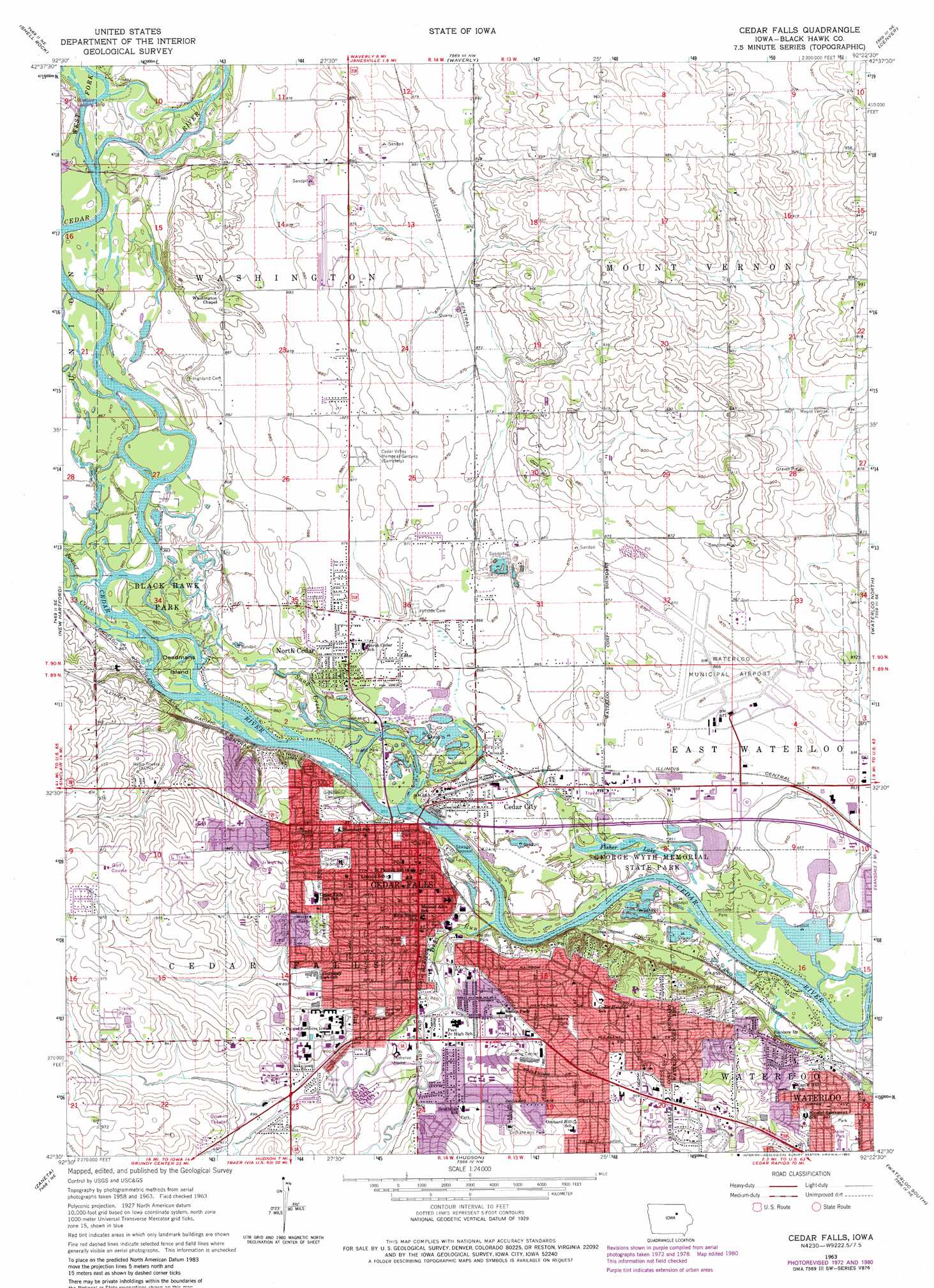
USGS Topo Quad 42092e4 - 1:24,000 scale
| Topo Map Name: | Cedar Falls |
| USGS Topo Quad ID: | 42092e4 |
| Print Size: | ca. 21 1/4" wide x 27" high |
| Southeast Coordinates: | 42.5° N latitude / 92.375° W longitude |
| Map Center Coordinates: | 42.5625° N latitude / 92.4375° W longitude |
| U.S. State: | IA |
| Filename: | o42092e4.jpg |
| Download Map JPG Image: | Cedar Falls topo map 1:24,000 scale |
| Map Type: | Topographic |
| Topo Series: | 7.5´ |
| Map Scale: | 1:24,000 |
| Source of Map Images: | United States Geological Survey (USGS) |
| Alternate Map Versions: |
Cedar Falls IA 1963, updated 1965 Download PDF Buy paper map Cedar Falls IA 1963, updated 1973 Download PDF Buy paper map Cedar Falls IA 1963, updated 1980 Download PDF Buy paper map Cedar Falls IA 1963, updated 1980 Download PDF Buy paper map Cedar Falls IA 2010 Download PDF Buy paper map Cedar Falls IA 2013 Download PDF Buy paper map Cedar Falls IA 2015 Download PDF Buy paper map |
1:24,000 Topo Quads surrounding Cedar Falls
Clarksville |
Plainfield |
Bremer |
Tripoli |
Sumner Sw |
Coster |
Shell Rock |
Waverly |
Denver |
Readlyn |
Stout |
New Hartford |
Cedar Falls |
Waterloo North |
Dunkerton |
Dike |
Zaneta |
Hudson |
Waterloo South |
Gilbertville |
Lincoln |
Reinbeck |
Buckingham |
Eagle Center |
La Porte City |
> Back to 42092e1 at 1:100,000 scale
> Back to 42092a1 at 1:250,000 scale
> Back to U.S. Topo Maps home
Cedar Falls topo map: Gazetteer
Cedar Falls: Airports
Lemons Airport elevation 297m 974′Waterloo Municipal Airport elevation 264m 866′
Cedar Falls: Islands
Blackwood Island elevation 256m 839′Deadmans Island elevation 262m 859′
Cedar Falls: Lakes
Fisher Lake elevation 257m 843′Cedar Falls: Parks
Baseball Park elevation 279m 915′Bess Streeter Aldrich Park elevation 268m 879′
Big Woods Lake Recreation Area elevation 259m 849′
Black Hawk Park elevation 262m 859′
Canfield Park elevation 259m 849′
Castle Bluff Park elevation 262m 859′
Castle Hill Park elevation 268m 879′
Cedar City Park elevation 262m 859′
Central Park elevation 262m 859′
Clay Street Park elevation 268m 879′
Dedication to Peter Melendy Historical Marker elevation 256m 839′
Dedication to Zimri Streeter Historical Marker elevation 266m 872′
First School in Cedar Falls Historical Marker elevation 264m 866′
First Settlers in Black Hawk County Historical Marker elevation 262m 859′
First Tower Bell in Iowa Historical Marker elevation 266m 872′
Galloway Park elevation 264m 866′
Hartman Reserve Nature Center elevation 260m 853′
Haven Park elevation 262m 859′
Historic Cedar Falls State Historical Marker elevation 265m 869′
Holmes Park elevation 287m 941′
Island Park elevation 262m 859′
Kiwanis Bluff Park elevation 282m 925′
Kuehns Park elevation 277m 908′
Lookout Park elevation 287m 941′
Orchard Hill Park elevation 282m 925′
Overman Park elevation 265m 869′
Paw Park elevation 266m 872′
Peter Melendy Park elevation 256m 839′
Pfeiffer Park elevation 269m 882′
Policemans Park elevation 262m 859′
Riverfront Park elevation 266m 872′
Roger Birdsall Memorial Park elevation 299m 980′
Rotary Reserve elevation 264m 866′
Round Park elevation 265m 869′
Sartori Hospital Park elevation 276m 905′
Seerley Park elevation 278m 912′
Skate Park elevation 264m 866′
Southdale Park elevation 277m 908′
Sturgis Park elevation 262m 859′
Tourist Park elevation 261m 856′
Ulrich Park elevation 262m 859′
Valley View Park elevation 277m 908′
Veterans Memorial Park elevation 271m 889′
Washington Park elevation 259m 849′
Cedar Falls: Populated Places
Boies elevation 291m 954′Castle Hill elevation 271m 889′
Cedar City elevation 262m 859′
Cedar Falls elevation 268m 879′
Cedar Falls Mobile Home Park elevation 280m 918′
Cedar Falls Mobile Home Village elevation 296m 971′
Five Seasons Mobile Home Park elevation 280m 918′
Gas Light Mobile Home Villa elevation 263m 862′
High Acres Mobile Home Park elevation 299m 980′
Lamplighter Villa elevation 261m 856′
Norris Siding elevation 266m 872′
North Cedar elevation 264m 866′
Cedar Falls: Post Offices
Boies Post Office (historical) elevation 286m 938′Cedar Falls Post Office elevation 267m 875′
Mount Hope Post Office (historical) elevation 259m 849′
Cedar Falls: Reservoirs
Alice Wyth Lake elevation 259m 849′Big Woods Lake elevation 262m 859′
East Lake elevation 254m 833′
George Wyth Lake elevation 259m 849′
Cedar Falls: Streams
Beaver Creek elevation 260m 853′Dry Run elevation 256m 839′
Snag Creek elevation 259m 849′
West Fork Cedar River elevation 260m 853′
Cedar Falls digital topo map on disk
Buy this Cedar Falls topo map showing relief, roads, GPS coordinates and other geographical features, as a high-resolution digital map file on DVD: