Shell Rock Topo Map Iowa
To zoom in, hover over the map of Shell Rock
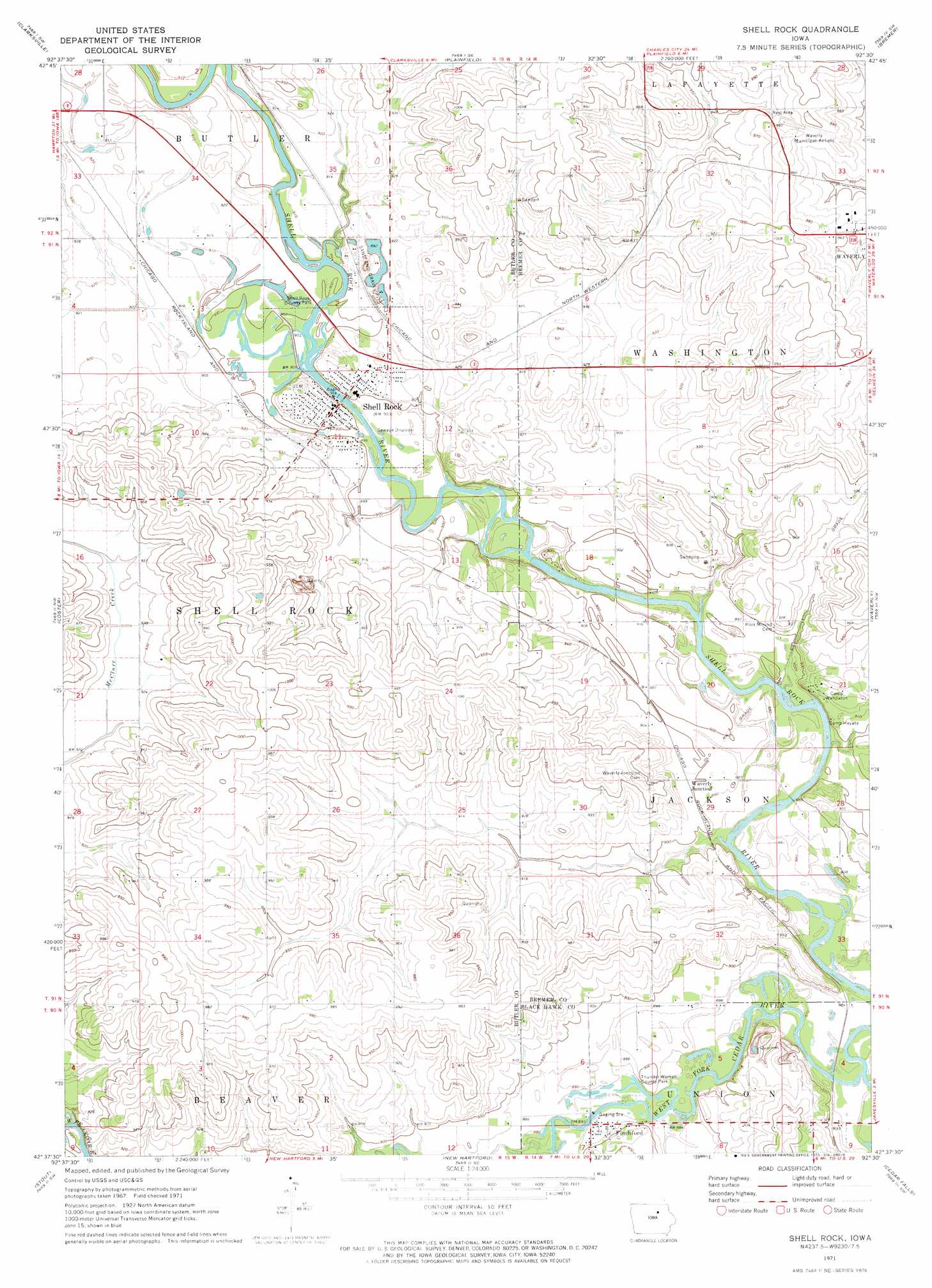
USGS Topo Quad 42092f5 - 1:24,000 scale
| Topo Map Name: | Shell Rock |
| USGS Topo Quad ID: | 42092f5 |
| Print Size: | ca. 21 1/4" wide x 27" high |
| Southeast Coordinates: | 42.625° N latitude / 92.5° W longitude |
| Map Center Coordinates: | 42.6875° N latitude / 92.5625° W longitude |
| U.S. State: | IA |
| Filename: | o42092f5.jpg |
| Download Map JPG Image: | Shell Rock topo map 1:24,000 scale |
| Map Type: | Topographic |
| Topo Series: | 7.5´ |
| Map Scale: | 1:24,000 |
| Source of Map Images: | United States Geological Survey (USGS) |
| Alternate Map Versions: |
Shell Rock IA 1971, updated 1973 Download PDF Buy paper map Shell Rock IA 2010 Download PDF Buy paper map Shell Rock IA 2013 Download PDF Buy paper map Shell Rock IA 2015 Download PDF Buy paper map |
1:24,000 Topo Quads surrounding Shell Rock
Greene |
Nashua Nw |
Nashua |
Tripoli Nw |
Frederika |
Allison |
Clarksville |
Plainfield |
Bremer |
Tripoli |
Butler Center |
Coster |
Shell Rock |
Waverly |
Denver |
Parkersburg |
Stout |
New Hartford |
Cedar Falls |
Waterloo North |
Holland |
Dike |
Zaneta |
Hudson |
Waterloo South |
> Back to 42092e1 at 1:100,000 scale
> Back to 42092a1 at 1:250,000 scale
> Back to U.S. Topo Maps home
Shell Rock topo map: Gazetteer
Shell Rock: Airports
Waverly Municipal Airport elevation 301m 987′Shell Rock: Bridges
Cherry Street Bridge elevation 271m 889′Shell Rock Bridge elevation 271m 889′
Waverly Junction Bridge elevation 266m 872′
Shell Rock: Parks
Shell Rock Access Area elevation 274m 898′Shell Rock County Park elevation 274m 898′
Shell Rock Wildlife Area elevation 274m 898′
Shell Rock Wildlife Area elevation 267m 875′
Thunder Woman County Park elevation 267m 875′
Shell Rock: Populated Places
Finchford elevation 269m 882′Shell Rock elevation 278m 912′
Waverly Junction elevation 275m 902′
Shell Rock: Post Offices
Finchford Post Office (historical) elevation 269m 882′Shell Rock Post Office elevation 278m 912′
Waverly Junction Post Office (historical) elevation 275m 902′
Winslow Post Office (historical) elevation 290m 951′
Shell Rock: Streams
Curry Creek elevation 273m 895′Klock Creek elevation 268m 879′
Shell Rock River elevation 266m 872′
Shell Rock digital topo map on disk
Buy this Shell Rock topo map showing relief, roads, GPS coordinates and other geographical features, as a high-resolution digital map file on DVD: