Story City Topo Map Iowa
To zoom in, hover over the map of Story City
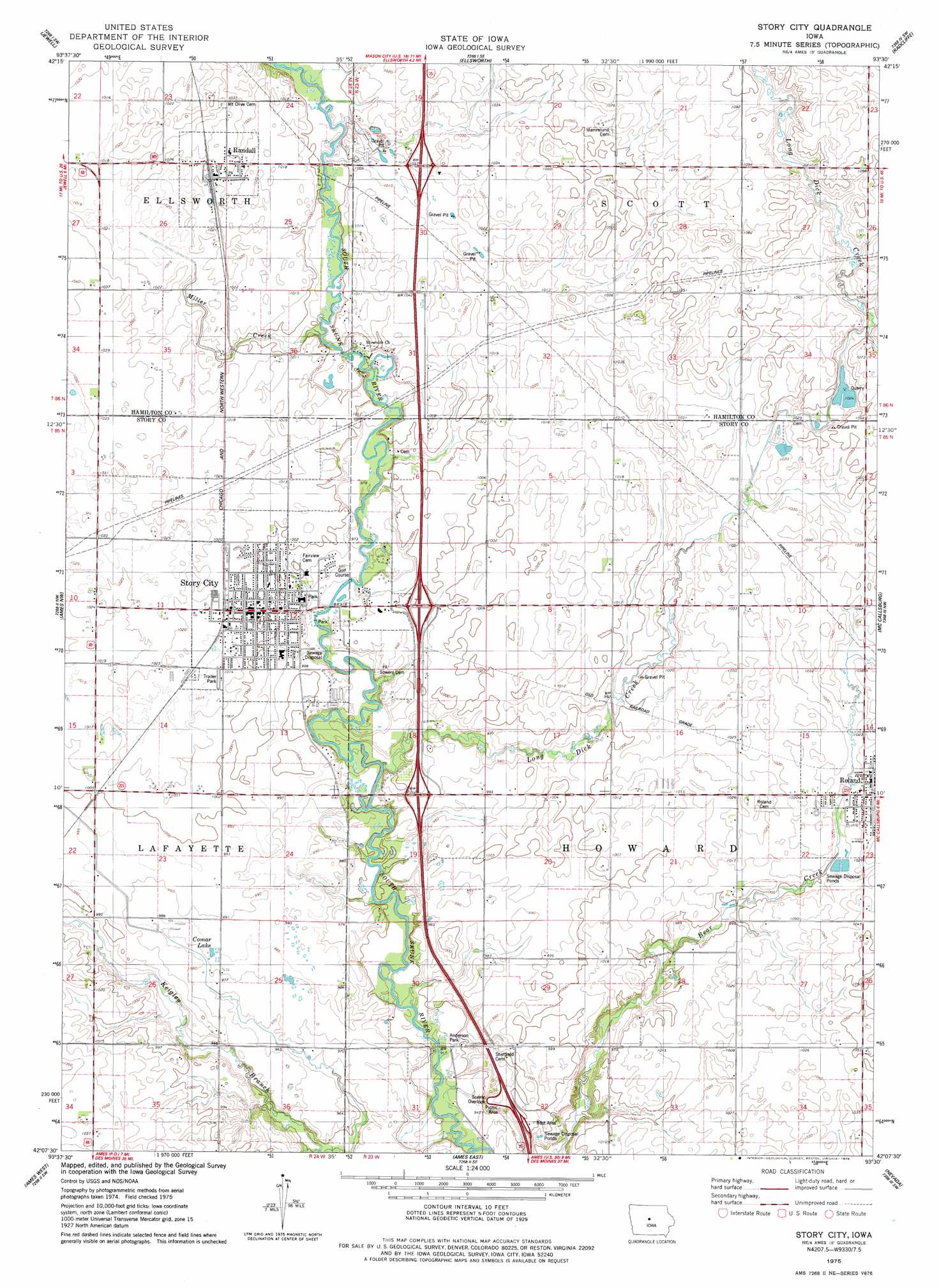
USGS Topo Quad 42093b5 - 1:24,000 scale
| Topo Map Name: | Story City |
| USGS Topo Quad ID: | 42093b5 |
| Print Size: | ca. 21 1/4" wide x 27" high |
| Southeast Coordinates: | 42.125° N latitude / 93.5° W longitude |
| Map Center Coordinates: | 42.1875° N latitude / 93.5625° W longitude |
| U.S. State: | IA |
| Filename: | o42093b5.jpg |
| Download Map JPG Image: | Story City topo map 1:24,000 scale |
| Map Type: | Topographic |
| Topo Series: | 7.5´ |
| Map Scale: | 1:24,000 |
| Source of Map Images: | United States Geological Survey (USGS) |
| Alternate Map Versions: |
Story City IA 1975, updated 1978 Download PDF Buy paper map Story City IA 2010 Download PDF Buy paper map Story City IA 2013 Download PDF Buy paper map Story City IA 2015 Download PDF Buy paper map |
1:24,000 Topo Quads surrounding Story City
Webster City |
Blairsburg |
Williams |
Buckeye West |
Buckeye East |
Stanhope |
Jewell |
Ellsworth |
Radcliffe |
Hubbard |
Mackey |
Ames Nw |
Story City |
Mccallsburg |
Zearing |
Boone East |
Ames West |
Ames East |
Nevada |
Colo |
Luther |
Slater |
Huxley |
Maxwell |
Collins |
> Back to 42093a1 at 1:100,000 scale
> Back to 42092a1 at 1:250,000 scale
> Back to U.S. Topo Maps home
Story City topo map: Gazetteer
Story City: Bridges
Keigley Branch Bridge elevation 294m 964′Story City: Crossings
Interchange 123 elevation 302m 990′Interchange 124 elevation 308m 1010′
Interchange 128 elevation 310m 1017′
Story City: Lakes
Comar Lake elevation 299m 980′Story City: Parks
Anderson Park elevation 287m 941′Doolittle Prairie State Preserve elevation 302m 990′
Heise Wildlife Area elevation 313m 1026′
Story City: Populated Places
Randall elevation 311m 1020′Roland elevation 312m 1023′
Story City elevation 306m 1003′
Story City: Post Offices
Randall Post Office elevation 311m 1020′Roland Post Office elevation 315m 1033′
Roland Post Office (historical) elevation 309m 1013′
Sheffield Post Office (historical) elevation 302m 990′
Story City Post Office elevation 305m 1000′
Willow Grove Post Office (historical) elevation 302m 990′
Story City: Streams
Long Dick Creek elevation 290m 951′Miller Creek elevation 299m 980′
Story City digital topo map on disk
Buy this Story City topo map showing relief, roads, GPS coordinates and other geographical features, as a high-resolution digital map file on DVD: