Webster City Topo Map Iowa
To zoom in, hover over the map of Webster City
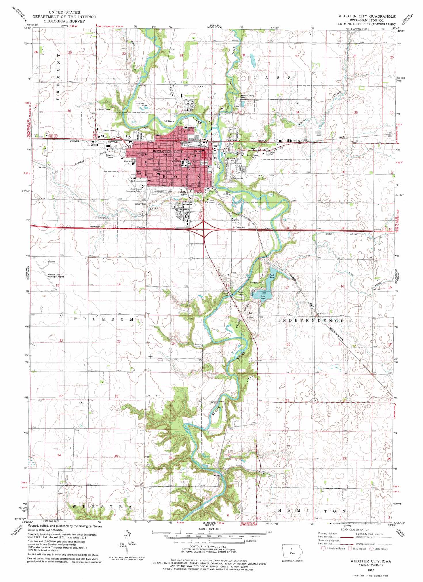
USGS Topo Quad 42093d7 - 1:24,000 scale
| Topo Map Name: | Webster City |
| USGS Topo Quad ID: | 42093d7 |
| Print Size: | ca. 21 1/4" wide x 27" high |
| Southeast Coordinates: | 42.375° N latitude / 93.75° W longitude |
| Map Center Coordinates: | 42.4375° N latitude / 93.8125° W longitude |
| U.S. State: | IA |
| Filename: | o42093d7.jpg |
| Download Map JPG Image: | Webster City topo map 1:24,000 scale |
| Map Type: | Topographic |
| Topo Series: | 7.5´ |
| Map Scale: | 1:24,000 |
| Source of Map Images: | United States Geological Survey (USGS) |
| Alternate Map Versions: |
Webster City IA 1978, updated 1979 Download PDF Buy paper map Webster City IA 2010 Download PDF Buy paper map Webster City IA 2013 Download PDF Buy paper map Webster City IA 2015 Download PDF Buy paper map |
1:24,000 Topo Quads surrounding Webster City
Thor |
Eagle Grove |
Holmes |
Clarion |
Dows West |
Vincent |
Eagle Grove Sw |
Woolstock |
Clarion Sw |
Sheldon Creek |
Evanston |
Duncombe |
Webster City |
Blairsburg |
Williams |
Lehigh |
Stratford |
Stanhope |
Jewell |
Ellsworth |
Boxholm |
Fraser |
Mackey |
Ames Nw |
Story City |
> Back to 42093a1 at 1:100,000 scale
> Back to 42092a1 at 1:250,000 scale
> Back to U.S. Topo Maps home
Webster City topo map: Gazetteer
Webster City: Airports
Hcph Heliport elevation 326m 1069′Webster City Municipal Airport elevation 340m 1115′
Webster City: Bridges
Albright Bridge elevation 299m 980′Tremaine Bridge elevation 293m 961′
Webster City: Canals
Ditch Number 166 elevation 332m 1089′Webster City: Parks
Barner Wildlife Area Number One elevation 315m 1033′Bauer Slough elevation 332m 1089′
Briggs Woods County Park elevation 309m 1013′
Dragoon Trail in Hamilton County Historical Marker elevation 320m 1049′
Drummer Boy at Shiloh Historical Marker elevation 331m 1085′
First White Settler in Webster City Historical Marker elevation 316m 1036′
Kendall Young Park elevation 318m 1043′
Nokomi's Park elevation 313m 1026′
Riverside City Park elevation 310m 1017′
Riverview Recreation Field elevation 313m 1026′
Wilson Brewer Memorial Park elevation 316m 1036′
Webster City: Populated Places
Hillcrest Mobile Home Park elevation 329m 1079′Webster City elevation 317m 1040′
Webster City: Post Offices
Poplar Grove Post Office (historical) elevation 338m 1108′Webster City Post Office elevation 320m 1049′
Webster City: Streams
Brewers Creek elevation 307m 1007′Buck Creek elevation 319m 1046′
Lyons Creek elevation 307m 1007′
White Fox Creek elevation 311m 1020′
Webster City digital topo map on disk
Buy this Webster City topo map showing relief, roads, GPS coordinates and other geographical features, as a high-resolution digital map file on DVD: