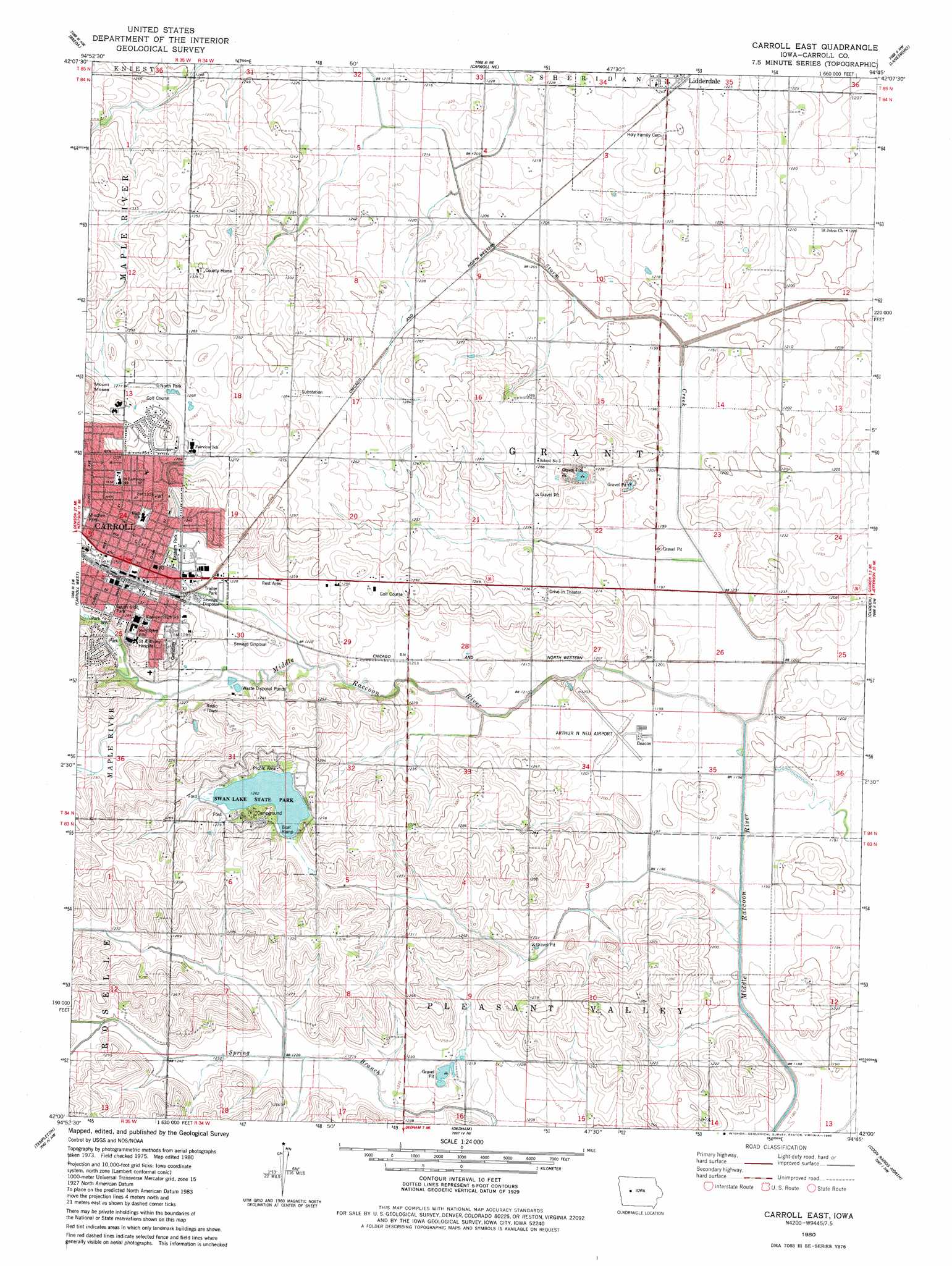
Carroll East Topo Map Iowa
To zoom in, hover over the map of Carroll East
USGS Topo Quad 42094a7 - 1:24,000 scale
| Topo Map Name: | Carroll East |
| USGS Topo Quad ID: | 42094a7 |
| Print Size: | ca. 21 1/4" wide x 27" high |
| Southeast Coordinates: | 42° N latitude / 94.75° W longitude |
| Map Center Coordinates: | 42.0625° N latitude / 94.8125° W longitude |
| U.S. State: | IA |
| Filename: | o42094a7.jpg |
| Download Map JPG Image: | Carroll East topo map 1:24,000 scale |
| Map Type: | Topographic |
| Topo Series: | 7.5´ |
| Map Scale: | 1:24,000 |
| Source of Map Images: | United States Geological Survey (USGS) |
| Alternate Map Versions: |
Carroll East IA 1980, updated 1980 Download PDF Buy paper map Carroll East IA 2010 Download PDF Buy paper map Carroll East IA 2013 Download PDF Buy paper map Carroll East IA 2015 Download PDF Buy paper map |
1:24,000 Topo Quads surrounding Carroll East
Lake View |
Grant City |
Yetter |
Lake City |
Lohrville |
Vail Ne |
Breda |
Carroll Ne |
Lanesboro |
Wightman |
Arcadia |
Carroll West |
Carroll East |
Glidden |
Scranton |
Manning |
Templeton |
Dedham |
Coon Rapids North |
Coon Rapids Ne |
Manning Se |
Gray |
Viola Center |
Coon Rapids South |
Bayard |
> Back to 42094a1 at 1:100,000 scale
> Back to 42094a1 at 1:250,000 scale
> Back to U.S. Topo Maps home
Carroll East topo map: Gazetteer
Carroll East: Airports
Arthur N Neu Airport elevation 366m 1200′Saint Anthony Regional Hospital Heliport elevation 390m 1279′
Carroll East: Bridges
Olympic Avenue Bridge elevation 366m 1200′Quail Avenue Bridge elevation 363m 1190′
Robin Avenue Bridge elevation 364m 1194′
Storm Creek Bridge elevation 366m 1200′
Storm Creek Bridge Two elevation 363m 1190′
Carroll East: Parks
Carroll Little League Complex elevation 390m 1279′Graham Park elevation 375m 1230′
Hazelton Wildlife Area elevation 363m 1190′
Minchen Park elevation 385m 1263′
North Park elevation 387m 1269′
Northeast Park elevation 395m 1295′
Rolling Hills Park elevation 375m 1230′
South Side Park elevation 387m 1269′
Swan Lake State Park elevation 385m 1263′
Veterans Memorial Park elevation 387m 1269′
Carroll East: Populated Places
Carroll elevation 387m 1269′Carroll Community Estates elevation 373m 1223′
Lidderdale elevation 377m 1236′
Carroll East: Post Offices
Carroll Post Office elevation 379m 1243′Lidderdale Post Office elevation 377m 1236′
Macks Post Office (historical) elevation 371m 1217′
Carroll East: Reservoirs
Swan Lake elevation 387m 1269′Carroll East: Streams
Storm Creek elevation 362m 1187′Carroll East: Summits
Mount Moses elevation 409m 1341′Carroll East digital topo map on disk
Buy this Carroll East topo map showing relief, roads, GPS coordinates and other geographical features, as a high-resolution digital map file on DVD: