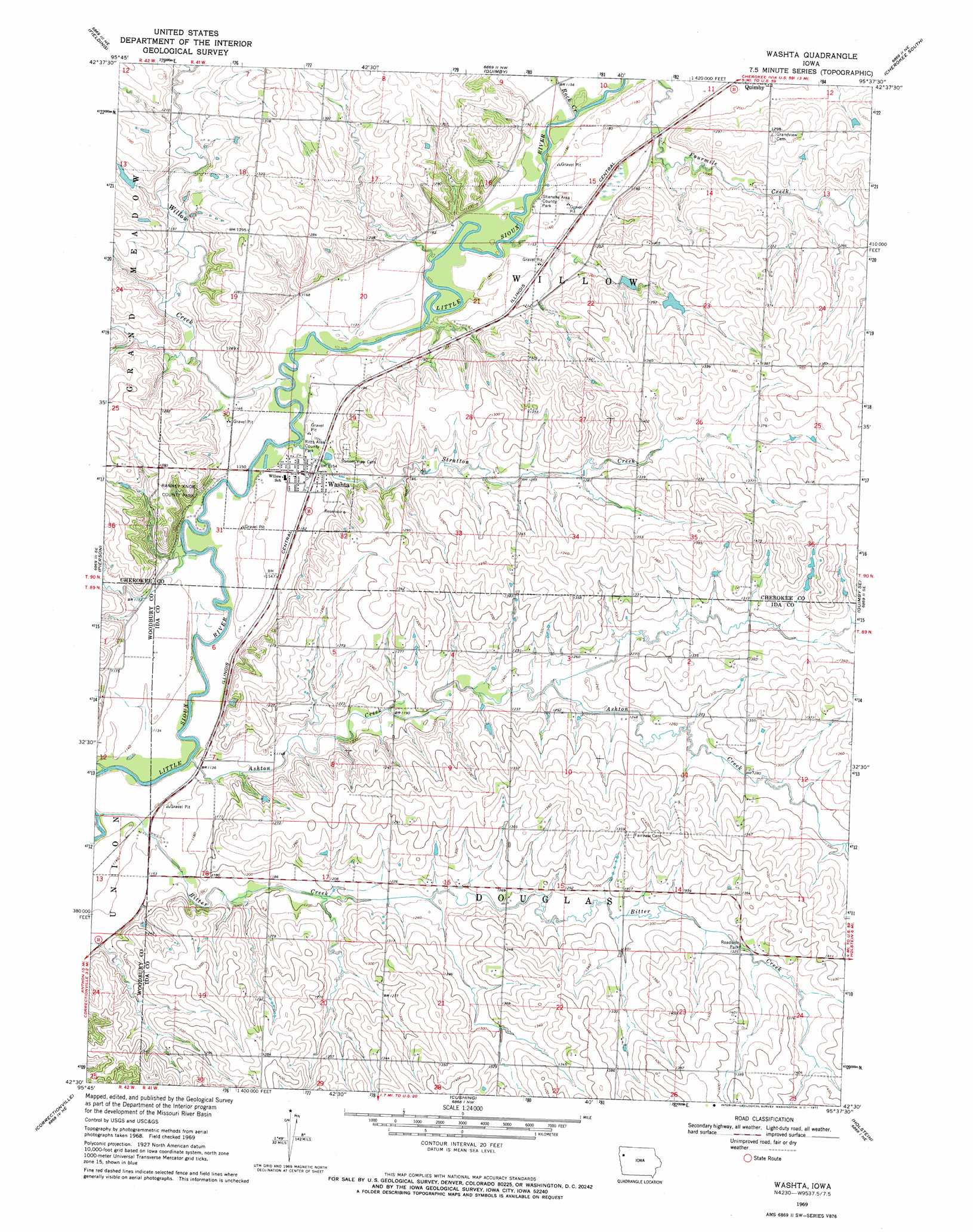
Washta Topo Map Iowa
To zoom in, hover over the map of Washta
USGS Topo Quad 42095e6 - 1:24,000 scale
| Topo Map Name: | Washta |
| USGS Topo Quad ID: | 42095e6 |
| Print Size: | ca. 21 1/4" wide x 27" high |
| Southeast Coordinates: | 42.5° N latitude / 95.625° W longitude |
| Map Center Coordinates: | 42.5625° N latitude / 95.6875° W longitude |
| U.S. State: | IA |
| Filename: | o42095e6.jpg |
| Download Map JPG Image: | Washta topo map 1:24,000 scale |
| Map Type: | Topographic |
| Topo Series: | 7.5´ |
| Map Scale: | 1:24,000 |
| Source of Map Images: | United States Geological Survey (USGS) |
| Alternate Map Versions: |
Washta IA 1969, updated 1971 Download PDF Buy paper map Washta IA 2010 Download PDF Buy paper map Washta IA 2013 Download PDF Buy paper map Washta IA 2015 Download PDF Buy paper map |
1:24,000 Topo Quads surrounding Washta
Remsen |
Marcus |
Cleghorn |
Cherokee North |
Peterson Sw |
Kingsley Nw |
Fielding |
Quimby |
Cherokee South |
Aurelia |
Kingsley |
Pierson |
Washta |
Quimby Se |
Galva |
Correctionville Nw |
Correctionville |
Cushing |
Holstein |
Ida Grove Nw |
Oto |
Correctionville Se |
Holstein Sw |
Battle Creek |
Ida Grove |
> Back to 42095e1 at 1:100,000 scale
> Back to 42094a1 at 1:250,000 scale
> Back to U.S. Topo Maps home
Washta topo map: Gazetteer
Washta: Parks
Douglas Township Cemetery Area elevation 420m 1377′Johnson Hienel Access Area elevation 347m 1138′
Little Sioux Greenbelt elevation 358m 1174′
Ranney Knob County Park elevation 344m 1128′
Ritts Area County Park elevation 342m 1122′
Stieneke Area County Park elevation 354m 1161′
Washta: Populated Places
Washta elevation 350m 1148′Washta: Post Offices
Washta Post Office elevation 350m 1148′Wendell Post Office (historical) elevation 348m 1141′
Washta: Streams
Ashton Creek elevation 341m 1118′Bitter Creek elevation 341m 1118′
Rock Creek elevation 348m 1141′
Stratton Creek elevation 341m 1118′
Willow Creek elevation 341m 1118′
Washta digital topo map on disk
Buy this Washta topo map showing relief, roads, GPS coordinates and other geographical features, as a high-resolution digital map file on DVD: