Burbank Topo Map Nebraska
To zoom in, hover over the map of Burbank
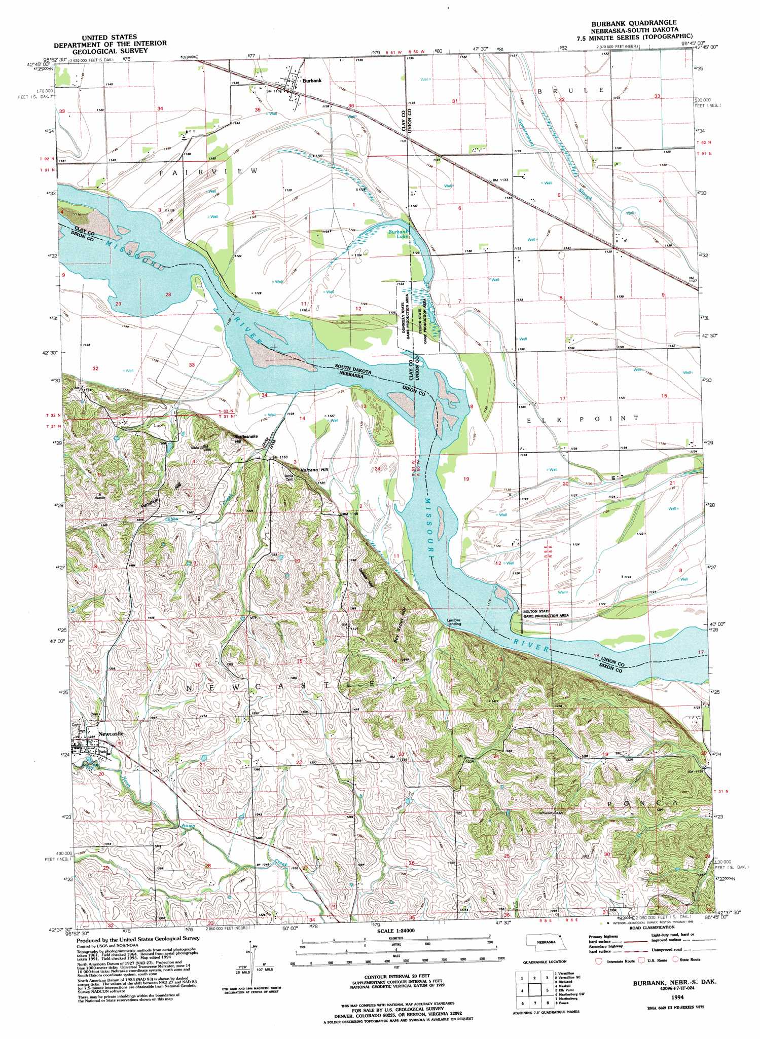
USGS Topo Quad 42096f7 - 1:24,000 scale
| Topo Map Name: | Burbank |
| USGS Topo Quad ID: | 42096f7 |
| Print Size: | ca. 21 1/4" wide x 27" high |
| Southeast Coordinates: | 42.625° N latitude / 96.75° W longitude |
| Map Center Coordinates: | 42.6875° N latitude / 96.8125° W longitude |
| U.S. States: | NE, SD |
| Filename: | O42096F7.jpg |
| Download Map JPG Image: | Burbank topo map 1:24,000 scale |
| Map Type: | Topographic |
| Topo Series: | 7.5´ |
| Map Scale: | 1:24,000 |
| Source of Map Images: | United States Geological Survey (USGS) |
| Alternate Map Versions: |
Burbank SD 1964, updated 1966 Download PDF Buy paper map Burbank SD 1994, updated 1995 Download PDF Buy paper map Burbank SD 2012 Download PDF Buy paper map Burbank SD 2015 Download PDF Buy paper map |
1:24,000 Topo Quads surrounding Burbank
Gayville Ne |
Hub City |
Alsen |
Nora |
Chatsworth |
Meckling |
Vermillon |
Vermillon Se |
Richland |
Akron |
Obert |
Maskell |
Burbank |
Elk Point |
Elk Point Ne |
Coleridge Se |
Martinsburg Sw |
Martinsburg |
Ponca |
Jefferson |
Laurel |
Concord |
Allen |
Waterbury |
Jackson |
> Back to 42096e1 at 1:100,000 scale
> Back to 42096a1 at 1:250,000 scale
> Back to U.S. Topo Maps home
Burbank topo map: Gazetteer
Burbank: Bends
Kate Sweeney Bend (historical) elevation 339m 1112′Burbank: Dams
Heald Dam elevation 354m 1161′Burbank: Lakes
Burbank Lake elevation 341m 1118′Burbank: Parks
Ionia 'Volcano' Historical Marker elevation 390m 1279′Pfister Park elevation 390m 1279′
Burbank: Populated Places
Burbank elevation 347m 1138′Ionia (historical) elevation 342m 1122′
Lembke Landing elevation 344m 1128′
Newcastle elevation 393m 1289′
Burbank: Post Offices
Ionia Post Office (historical) elevation 338m 1108′Newcastle Post Office elevation 393m 1289′
Burbank: Reservoirs
Heald Reservoir elevation 354m 1161′Burbank: Streams
Gibbs Creek elevation 339m 1112′Burbank: Summits
Boy Scout Hill elevation 430m 1410′Indian Hill elevation 426m 1397′
Pumpkin Hill elevation 429m 1407′
Rattlesnake Hill elevation 394m 1292′
Volcano Hill elevation 384m 1259′
Burbank digital topo map on disk
Buy this Burbank topo map showing relief, roads, GPS coordinates and other geographical features, as a high-resolution digital map file on DVD: