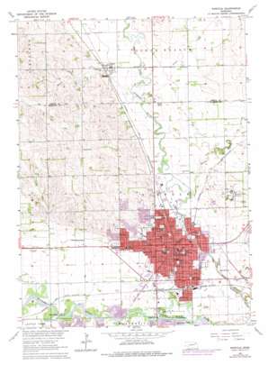
Norfolk Topo Map Nebraska
To zoom in, hover over the map of Norfolk
USGS Topo Quad 42097a4 - 1:24,000 scale
| Topo Map Name: | Norfolk |
| USGS Topo Quad ID: | 42097a4 |
| Print Size: | ca. 21 1/4" wide x 27" high |
| Southeast Coordinates: | 42° N latitude / 97.375° W longitude |
| Map Center Coordinates: | 42.0625° N latitude / 97.4375° W longitude |
| U.S. State: | NE |
| Filename: | O42097A4.jpg |
| Download Map JPG Image: | Norfolk topo map 1:24,000 scale |
| Map Type: | Topographic |
| Topo Series: | 7.5´ |
| Map Scale: | 1:24,000 |
| Source of Map Images: | United States Geological Survey (USGS) |
| Alternate Map Versions: |
Norfolk NE 1963, updated 1964 Download PDF Buy paper map Norfolk NE 1963, updated 1977 Download PDF Buy paper map Norfolk NE 2011 Download PDF Buy paper map Norfolk NE 2014 Download PDF Buy paper map |
1:24,000 Topo Quads surrounding Norfolk
> Back to 42097a1 at 1:100,000 scale
> Back to 42096a1 at 1:250,000 scale
> Back to U.S. Topo Maps home
Norfolk topo map: Gazetteer
Norfolk: Bridges
Broken Bridge elevation 467m 1532′Norfolk: Dams
Mill Bridge Dam elevation 458m 1502′Multi-Purpose Dam 1-A elevation 482m 1581′
Raasch Dam elevation 478m 1568′
Norfolk: Lakes
Medelmans Lake elevation 460m 1509′Norfolk: Parks
Central Park elevation 464m 1522′City Square Park elevation 463m 1519′
Elkhorn State Wildlife Management Area elevation 472m 1548′
Johnson Park elevation 461m 1512′
Liberty Bell Park elevation 465m 1525′
Memorial Park elevation 461m 1512′
Nord Park elevation 472m 1548′
Skyview Park elevation 491m 1610′
Ta-Ha-Zouka Park elevation 461m 1512′
Verges Park elevation 467m 1532′
Verges Park Historical Marker elevation 468m 1535′
Norfolk: Populated Places
Hadar elevation 473m 1551′Mackels Mobile Home Court elevation 464m 1522′
Norfolk elevation 464m 1522′
Norfolk Mobile Home Community elevation 464m 1522′
Norfolk: Post Offices
Hadar Post Office elevation 473m 1551′Norfolk Post Office elevation 463m 1519′
Norfolk: Reservoirs
Lake Norfolk elevation 482m 1581′Raasch Reservoir elevation 478m 1568′
Skyview Lake elevation 482m 1581′
Norfolk: Streams
Hadar Creek elevation 466m 1528′Spring Branch elevation 463m 1519′
Turtle Creek elevation 466m 1528′
Norfolk: Trails
Norfolk-Riverfront Trail elevation 464m 1522′Norfolk-Skyview Trail elevation 487m 1597′
Norfolk: Valleys
Corporation Gulch elevation 460m 1509′Norfolk digital topo map on disk
Buy this Norfolk topo map showing relief, roads, GPS coordinates and other geographical features, as a high-resolution digital map file on DVD:


