Mills Topo Map Nebraska
To zoom in, hover over the map of Mills
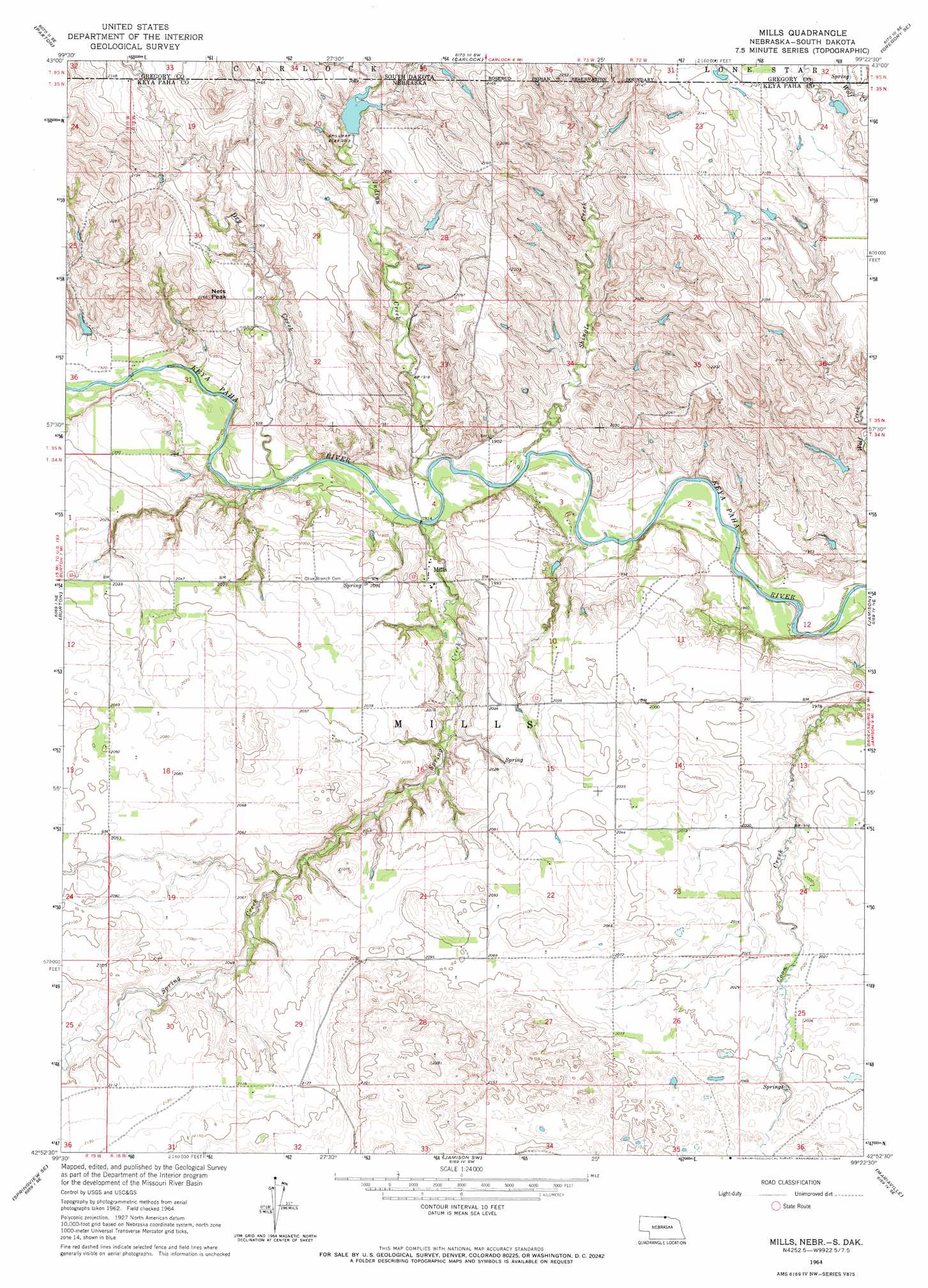
USGS Topo Quad 42099h4 - 1:24,000 scale
| Topo Map Name: | Mills |
| USGS Topo Quad ID: | 42099h4 |
| Print Size: | ca. 21 1/4" wide x 27" high |
| Southeast Coordinates: | 42.875° N latitude / 99.375° W longitude |
| Map Center Coordinates: | 42.9375° N latitude / 99.4375° W longitude |
| U.S. States: | NE, SD |
| Filename: | O42099H4.jpg |
| Download Map JPG Image: | Mills topo map 1:24,000 scale |
| Map Type: | Topographic |
| Topo Series: | 7.5´ |
| Map Scale: | 1:24,000 |
| Source of Map Images: | United States Geological Survey (USGS) |
| Alternate Map Versions: |
Mills NE 1964, updated 1965 Download PDF Buy paper map Mills NE 2011 Download PDF Buy paper map Mills NE 2014 Download PDF Buy paper map |
1:24,000 Topo Quads surrounding Mills
Dallas Nw |
Dallas |
Gregory |
Burke |
Herrick Nw |
Dallas Sw |
Paxton |
Carlock |
Gregory Se |
Herrick |
Springview Nw |
Burton |
Mills |
Jamison |
Naper Nw |
Springview |
Springview Se |
Jamison Sw |
Mariaville |
Naper Sw |
Bassett Nw |
Riverview |
Carns |
Newport Ne |
Stuart Nw |
> Back to 42099e1 at 1:100,000 scale
> Back to 42098a1 at 1:250,000 scale
> Back to U.S. Topo Maps home
Mills topo map: Gazetteer
Mills: Dams
Kaupp Dam Number 4 elevation 604m 1981′Kaupp Dam West elevation 614m 2014′
Kaupp East Dam elevation 634m 2080′
Kaupp SW Dam elevation 593m 1945′
Peterson Dam Number 2 elevation 614m 2014′
Rowan Dam elevation 578m 1896′
Serr Dam elevation 625m 2050′
Mills: Populated Places
Mills elevation 585m 1919′Mills: Post Offices
Mills Post Office elevation 585m 1919′Mills: Reservoirs
Kaupp East Reservoir elevation 634m 2080′Kaupp Reservoir Number 4 elevation 604m 1981′
Kaupp Reservoir West elevation 614m 2014′
Kaupp SW Reservoir elevation 593m 1945′
Peterson Reservoir Number 2 elevation 614m 2014′
Rowan Reservoir elevation 578m 1896′
Serr Reservoir elevation 625m 2050′
Mills: Streams
Dry Creek elevation 576m 1889′Dry Creek elevation 576m 1889′
Indian Creek elevation 573m 1879′
Indian Creek elevation 572m 1876′
Shingle Creek elevation 568m 1863′
Shingle Creek elevation 569m 1866′
Mills: Summits
Nets Peak elevation 677m 2221′Mills digital topo map on disk
Buy this Mills topo map showing relief, roads, GPS coordinates and other geographical features, as a high-resolution digital map file on DVD: