Snake River Falls Topo Map Nebraska
To zoom in, hover over the map of Snake River Falls
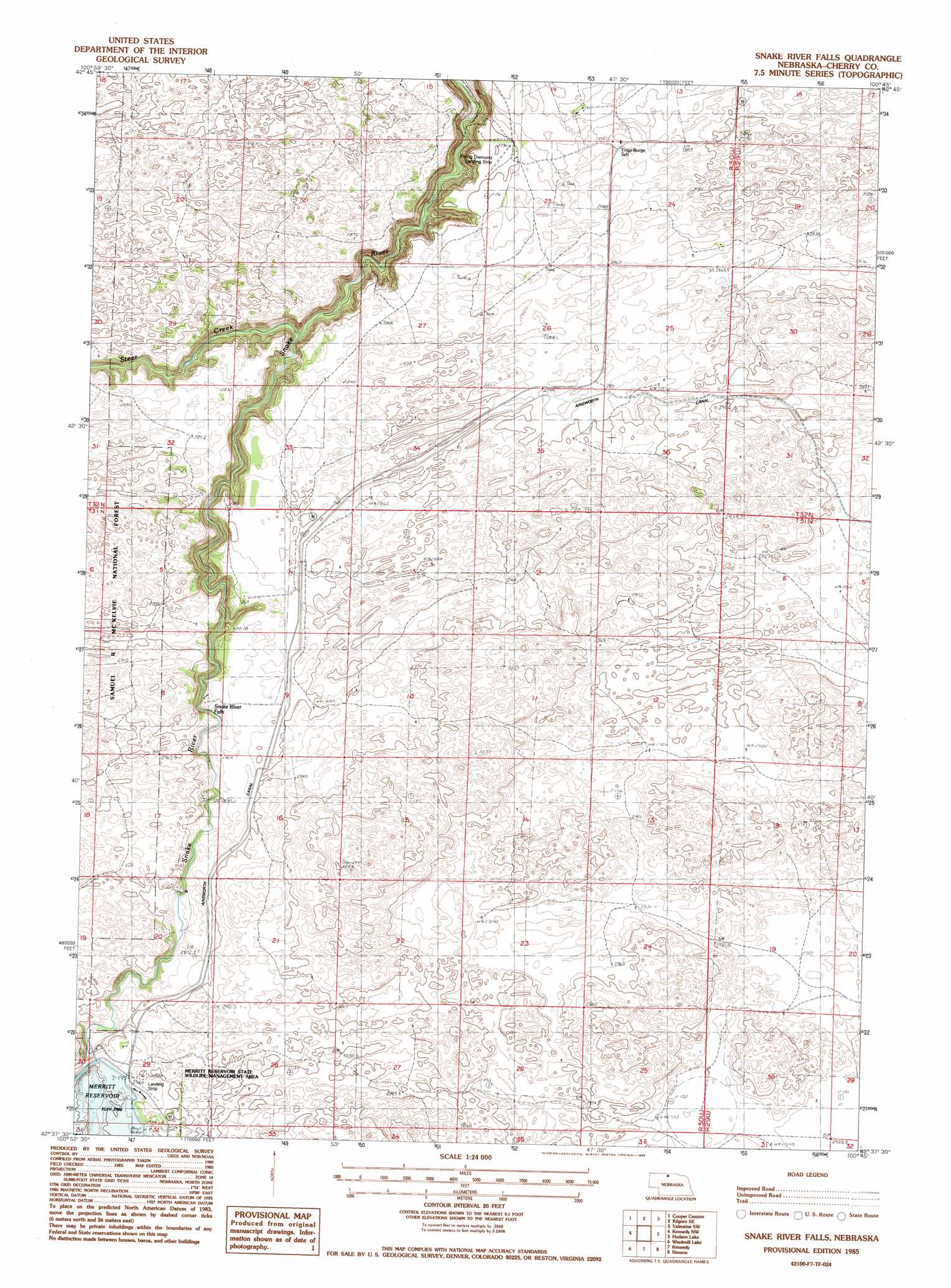
USGS Topo Quad 42100f7 - 1:24,000 scale
| Topo Map Name: | Snake River Falls |
| USGS Topo Quad ID: | 42100f7 |
| Print Size: | ca. 21 1/4" wide x 27" high |
| Southeast Coordinates: | 42.625° N latitude / 100.75° W longitude |
| Map Center Coordinates: | 42.6875° N latitude / 100.8125° W longitude |
| U.S. State: | NE |
| Filename: | O42100f7.jpg |
| Download Map JPG Image: | Snake River Falls topo map 1:24,000 scale |
| Map Type: | Topographic |
| Topo Series: | 7.5´ |
| Map Scale: | 1:24,000 |
| Source of Map Images: | United States Geological Survey (USGS) |
| Alternate Map Versions: |
Snake River Falls NE 1985, updated 1985 Download PDF Buy paper map Snake River Falls NE 2011 Download PDF Buy paper map Snake River Falls NE 2014 Download PDF Buy paper map |
| FStopo: | US Forest Service topo Snake River Falls is available: Download FStopo PDF Download FStopo TIF |
1:24,000 Topo Quads surrounding Snake River Falls
Nenzel |
Kilgore |
Crookston West |
Crookston East |
Valentine North |
Cody Se |
Cooper Canyon |
Kilgore Se |
Valentine Sw |
Valentine South |
Powderhorn Valley |
Kennedy Nw |
Snake River Falls |
Hudson Lake |
Ell Lake |
Chesterfield Flats |
Windmill Lake |
Kennedy |
Simeon |
Willow Lake |
Brush Hill |
Square Lake |
Bull Lake |
Mule Lake |
Pony Lake |
> Back to 42100e1 at 1:100,000 scale
> Back to 42100a1 at 1:250,000 scale
> Back to U.S. Topo Maps home
Snake River Falls topo map: Gazetteer
Snake River Falls: Airports
Flying Diamond Landing Strip elevation 852m 2795′Merritt Dam Landing Strip elevation 909m 2982′
Snake River Falls: Bridges
Falls Bridge elevation 898m 2946′Snake River Falls: Dams
Merritt Dam elevation 882m 2893′Snake River Falls: Falls
Snake River Falls elevation 858m 2814′Snake River Falls: Reservoirs
Merritt Reservoir elevation 882m 2893′Snake River Falls: Streams
Steer Creek elevation 802m 2631′Snake River Falls digital topo map on disk
Buy this Snake River Falls topo map showing relief, roads, GPS coordinates and other geographical features, as a high-resolution digital map file on DVD: