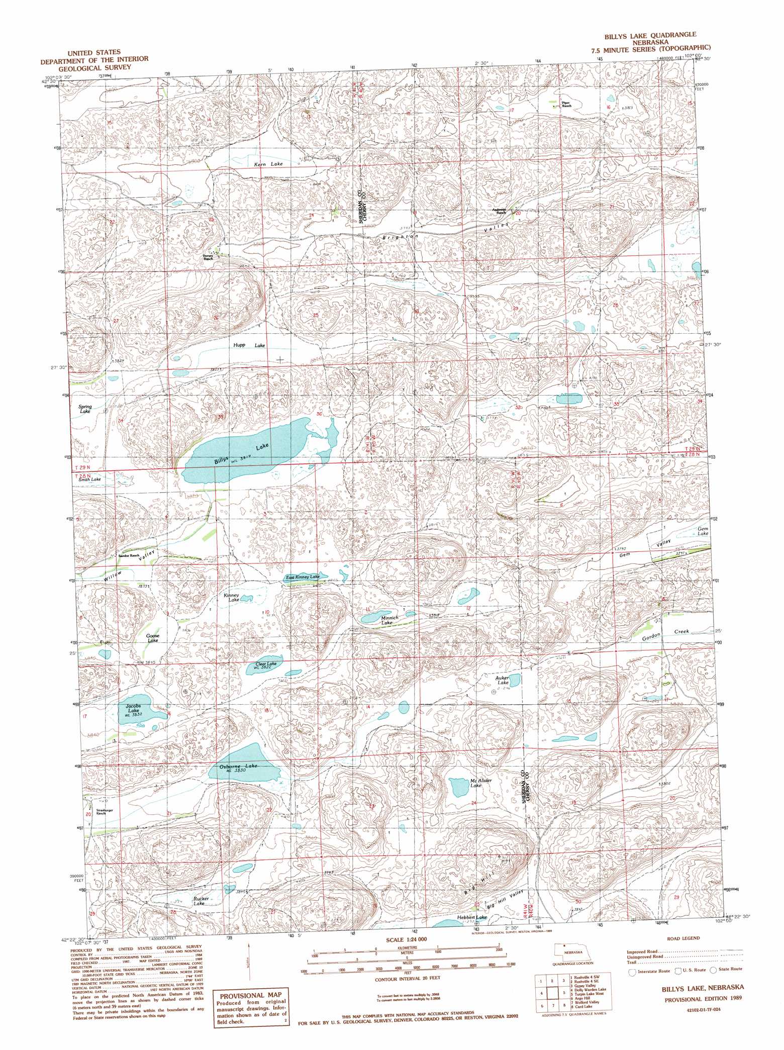
Billys Lake Topo Map Nebraska
To zoom in, hover over the map of Billys Lake
USGS Topo Quad 42102d1 - 1:24,000 scale
| Topo Map Name: | Billys Lake |
| USGS Topo Quad ID: | 42102d1 |
| Print Size: | ca. 21 1/4" wide x 27" high |
| Southeast Coordinates: | 42.375° N latitude / 102° W longitude |
| Map Center Coordinates: | 42.4375° N latitude / 102.0625° W longitude |
| U.S. State: | NE |
| Filename: | O42102D1.jpg |
| Download Map JPG Image: | Billys Lake topo map 1:24,000 scale |
| Map Type: | Topographic |
| Topo Series: | 7.5´ |
| Map Scale: | 1:24,000 |
| Source of Map Images: | United States Geological Survey (USGS) |
| Alternate Map Versions: |
Billys Lake NE 1989, updated 1989 Download PDF Buy paper map Billys Lake NE 2011 Download PDF Buy paper map Billys Lake NE 2014 Download PDF Buy paper map |
1:24,000 Topo Quads surrounding Billys Lake
Rushville Ne |
Rushville 4 Nw |
Rushville 4 Ne |
Pole Creek Valley |
Bornemann Lake |
Rushville Se |
Rushville 4 Sw |
Rushville 4 Se |
Gypsy Valley |
North Valley |
Twin Lakes Ne |
Dolly Warden Lake |
Billys Lake |
Turpin Lake West |
Turpin Lake East |
Green Lake |
Argo Hill |
Wolford Valley |
Card Lake |
Bristol Lake |
White Lake |
Arnold Lake |
Lowe Valley |
Camp Valley |
Mother Lake |
> Back to 42102a1 at 1:100,000 scale
> Back to 42102a1 at 1:250,000 scale
> Back to U.S. Topo Maps home
Billys Lake topo map: Gazetteer
Billys Lake: Basins
Brighton Valley elevation 1163m 3815′Gem Valley elevation 1154m 3786′
White Valley elevation 1156m 3792′
Willow Valley elevation 1165m 3822′
Billys Lake: Lakes
Auker Lake elevation 1162m 3812′Billys Lake elevation 1163m 3815′
Clear Lake elevation 1165m 3822′
East Kinney Lake elevation 1166m 3825′
Goose Lake elevation 1169m 3835′
Hupp Lake elevation 1164m 3818′
Jacobs Lake elevation 1169m 3835′
Kern Lake elevation 1157m 3795′
Kinney Lake elevation 1171m 3841′
McAlister Lake elevation 1161m 3809′
Minnich Lake elevation 1162m 3812′
Osborne Lake elevation 1168m 3832′
Rucker Lake elevation 1171m 3841′
Smith Lake elevation 1164m 3818′
Billys Lake: Summits
Big Hill elevation 1261m 4137′Billys Lake: Valleys
Big Hill Valley elevation 1170m 3838′Billys Lake digital topo map on disk
Buy this Billys Lake topo map showing relief, roads, GPS coordinates and other geographical features, as a high-resolution digital map file on DVD:
Eastern Wyoming & Western South Dakota
Buy digital topo maps: Eastern Wyoming & Western South Dakota