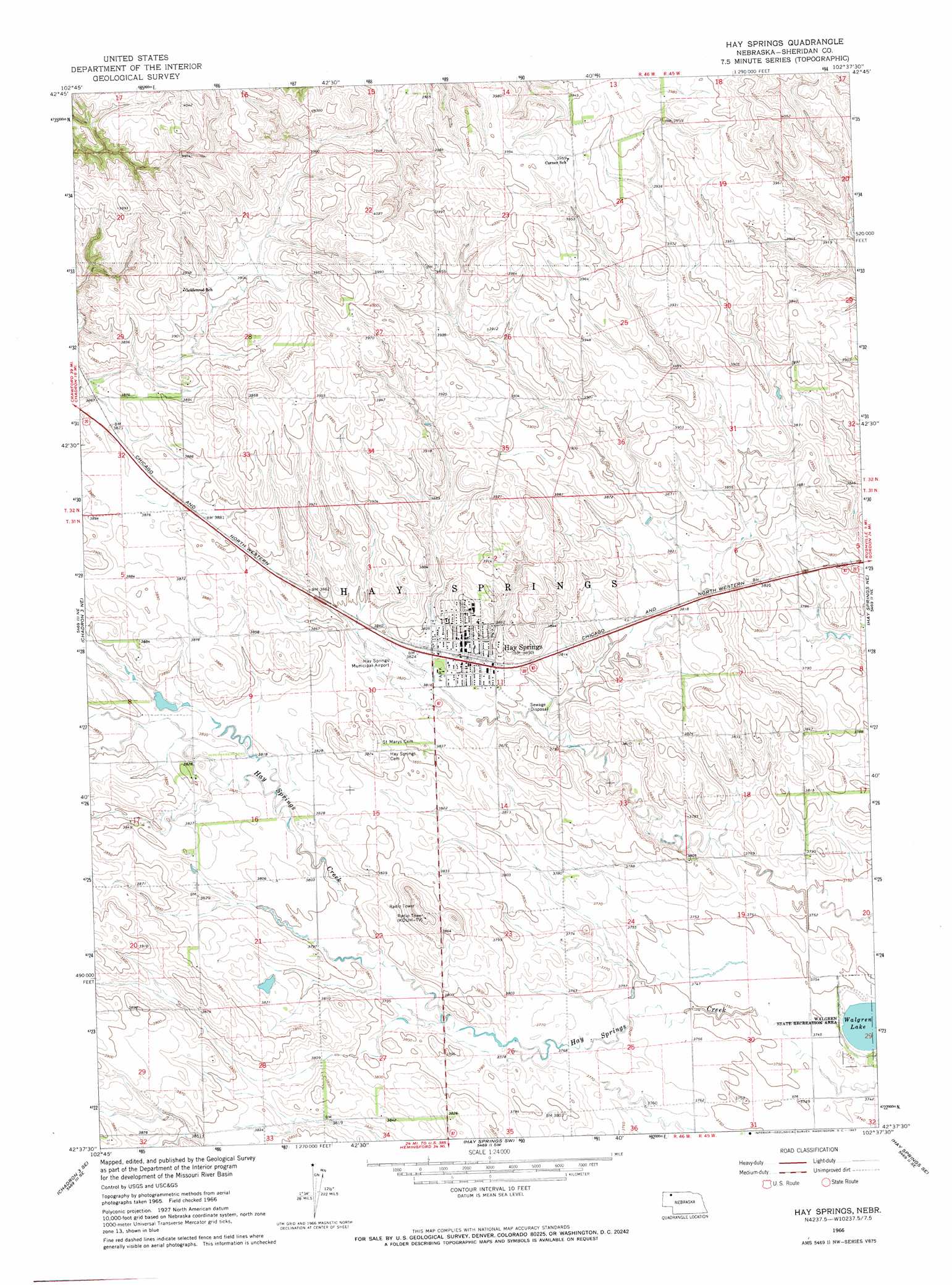
Hay Springs Topo Map Nebraska
To zoom in, hover over the map of Hay Springs
USGS Topo Quad 42102f6 - 1:24,000 scale
| Topo Map Name: | Hay Springs |
| USGS Topo Quad ID: | 42102f6 |
| Print Size: | ca. 21 1/4" wide x 27" high |
| Southeast Coordinates: | 42.625° N latitude / 102.625° W longitude |
| Map Center Coordinates: | 42.6875° N latitude / 102.6875° W longitude |
| U.S. State: | NE |
| Filename: | O42102F6.jpg |
| Download Map JPG Image: | Hay Springs topo map 1:24,000 scale |
| Map Type: | Topographic |
| Topo Series: | 7.5´ |
| Map Scale: | 1:24,000 |
| Source of Map Images: | United States Geological Survey (USGS) |
| Alternate Map Versions: |
Hay Springs NE 1966, updated 1967 Download PDF Buy paper map Hay Springs NE 2011 Download PDF Buy paper map Hay Springs NE 2014 Download PDF Buy paper map |
1:24,000 Topo Quads surrounding Hay Springs
Isinglass Buttes |
Chadron Ne |
Beaver Wall |
Whiteclay |
Clinton Nw |
Chadron East |
Bordeaux |
Whiteclay Sw |
Whiteclay Se |
Clinton Sw |
Chadron 3 Nw |
Chadron 3 Ne |
Hay Springs |
Hay Springs Ne |
Rushville |
Chadron 3 Sw |
Chadron 3 Se |
Hay Springs Sw |
Hay Springs Se |
Rushville Sw |
Box Butte Nw |
Box Butte Ne |
Skunk Lake Nw |
Skunk Lake Ne |
Smith Lake |
> Back to 42102e1 at 1:100,000 scale
> Back to 42102a1 at 1:250,000 scale
> Back to U.S. Topo Maps home
Hay Springs topo map: Gazetteer
Hay Springs: Airports
Hay Springs Municipal Airport elevation 1167m 3828′Hay Springs: Dams
Davis Dam elevation 1184m 3884′Linden Dam elevation 1172m 3845′
Hay Springs: Lakes
Walgren Lake elevation 1138m 3733′Hay Springs: Parks
Camp Sheridan and Spotted Tail Agency Historical Marker elevation 1170m 3838′Walgren Lake State Recreation Area elevation 1141m 3743′
Hay Springs: Populated Places
Hay Springs elevation 1170m 3838′Hay Springs: Post Offices
Hay Springs Post Office elevation 1170m 3838′Hay Springs: Reservoirs
Davis Reservoir elevation 1184m 3884′Linden Reservoir elevation 1172m 3845′
Hay Springs: Streams
Hay Springs Creek elevation 1153m 3782′Hay Springs digital topo map on disk
Buy this Hay Springs topo map showing relief, roads, GPS coordinates and other geographical features, as a high-resolution digital map file on DVD:
Eastern Wyoming & Western South Dakota
Buy digital topo maps: Eastern Wyoming & Western South Dakota