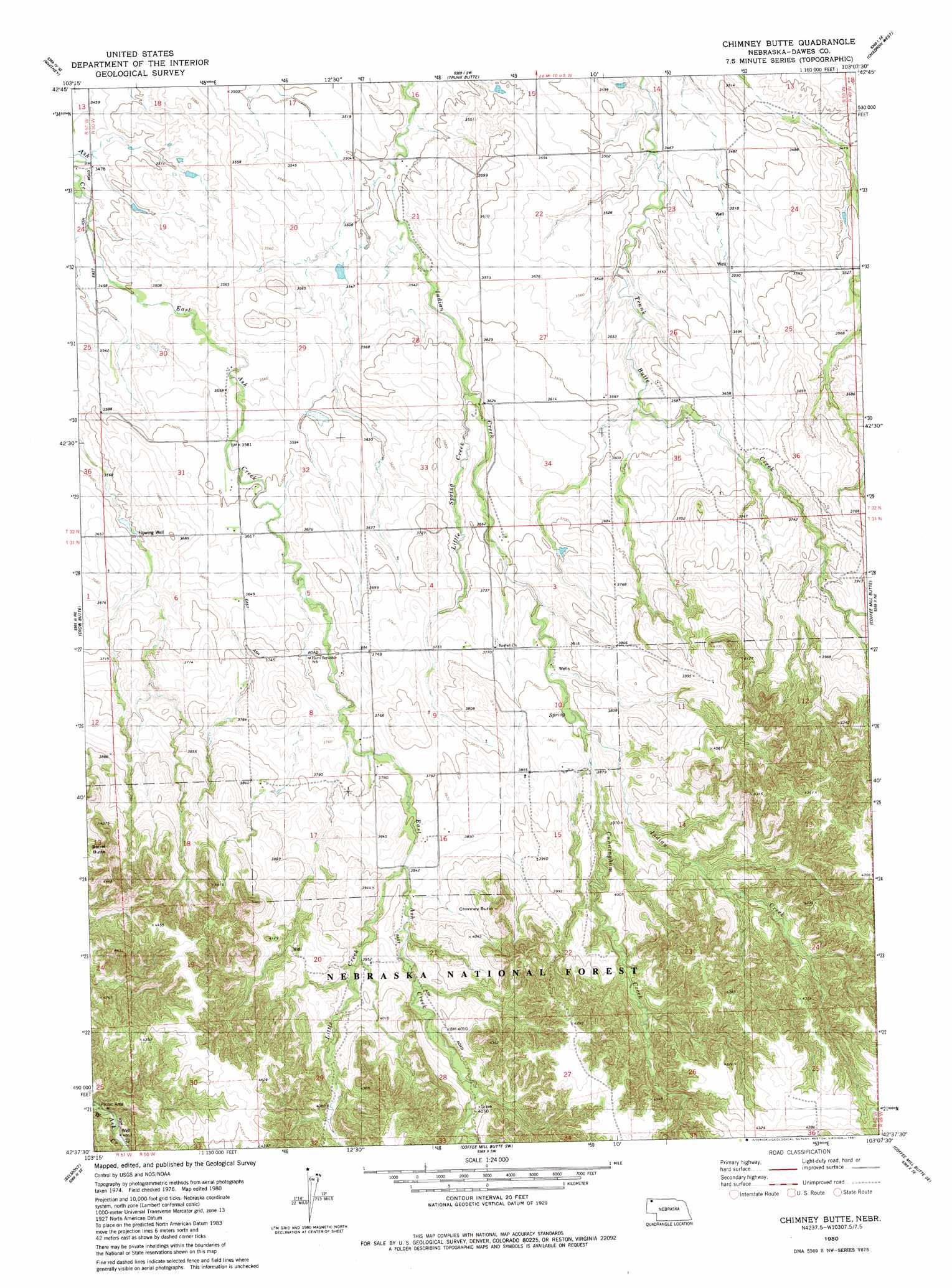
Chimney Butte Topo Map Nebraska
To zoom in, hover over the map of Chimney Butte
USGS Topo Quad 42103f2 - 1:24,000 scale
| Topo Map Name: | Chimney Butte |
| USGS Topo Quad ID: | 42103f2 |
| Print Size: | ca. 21 1/4" wide x 27" high |
| Southeast Coordinates: | 42.625° N latitude / 103.125° W longitude |
| Map Center Coordinates: | 42.6875° N latitude / 103.1875° W longitude |
| U.S. State: | NE |
| Filename: | O42103F2.jpg |
| Download Map JPG Image: | Chimney Butte topo map 1:24,000 scale |
| Map Type: | Topographic |
| Topo Series: | 7.5´ |
| Map Scale: | 1:24,000 |
| Source of Map Images: | United States Geological Survey (USGS) |
| Alternate Map Versions: |
Chimney Butte NE 1980, updated 1981 Download PDF Buy paper map Chimney Butte NE 2011 Download PDF Buy paper map Chimney Butte NE 2014 Download PDF Buy paper map |
| FStopo: | US Forest Service topo Chimney Butte is available: Download FStopo PDF Download FStopo TIF |
1:24,000 Topo Quads surrounding Chimney Butte
Wolf Butte |
Lone Tree Ranch |
Wayside |
Bohemian Creek |
Isinglass Buttes |
Horn |
Whitney |
Trunk Butte |
Chadron West |
Chadron East |
Crawford |
Crow Butte |
Chimney Butte |
Coffee Mill Butte |
Chadron 3 Nw |
Dead Mans Creek |
Belmont |
Coffee Mill Butte Sw |
Coffee Mill Butte Se |
Chadron 3 Sw |
Marsland Nw |
Marsland Ne |
Box Butte Reservoir West |
Box Butte Reservoir East |
Box Butte Nw |
> Back to 42103e1 at 1:100,000 scale
> Back to 42102a1 at 1:250,000 scale
> Back to U.S. Topo Maps home
Chimney Butte topo map: Gazetteer
Chimney Butte: Streams
Cunningham Creek elevation 1159m 3802′Little Creek elevation 1165m 3822′
Little Spring Creek elevation 1092m 3582′
West Ash Creek elevation 1229m 4032′
Chimney Butte: Summits
Barrel Butte elevation 1273m 4176′Chimney Butte elevation 1242m 4074′
Chimney Butte: Trails
Roberts Trail elevation 1236m 4055′Rock Butte Loop elevation 1311m 4301′
Chimney Butte digital topo map on disk
Buy this Chimney Butte topo map showing relief, roads, GPS coordinates and other geographical features, as a high-resolution digital map file on DVD:
Eastern Wyoming & Western South Dakota
Buy digital topo maps: Eastern Wyoming & Western South Dakota