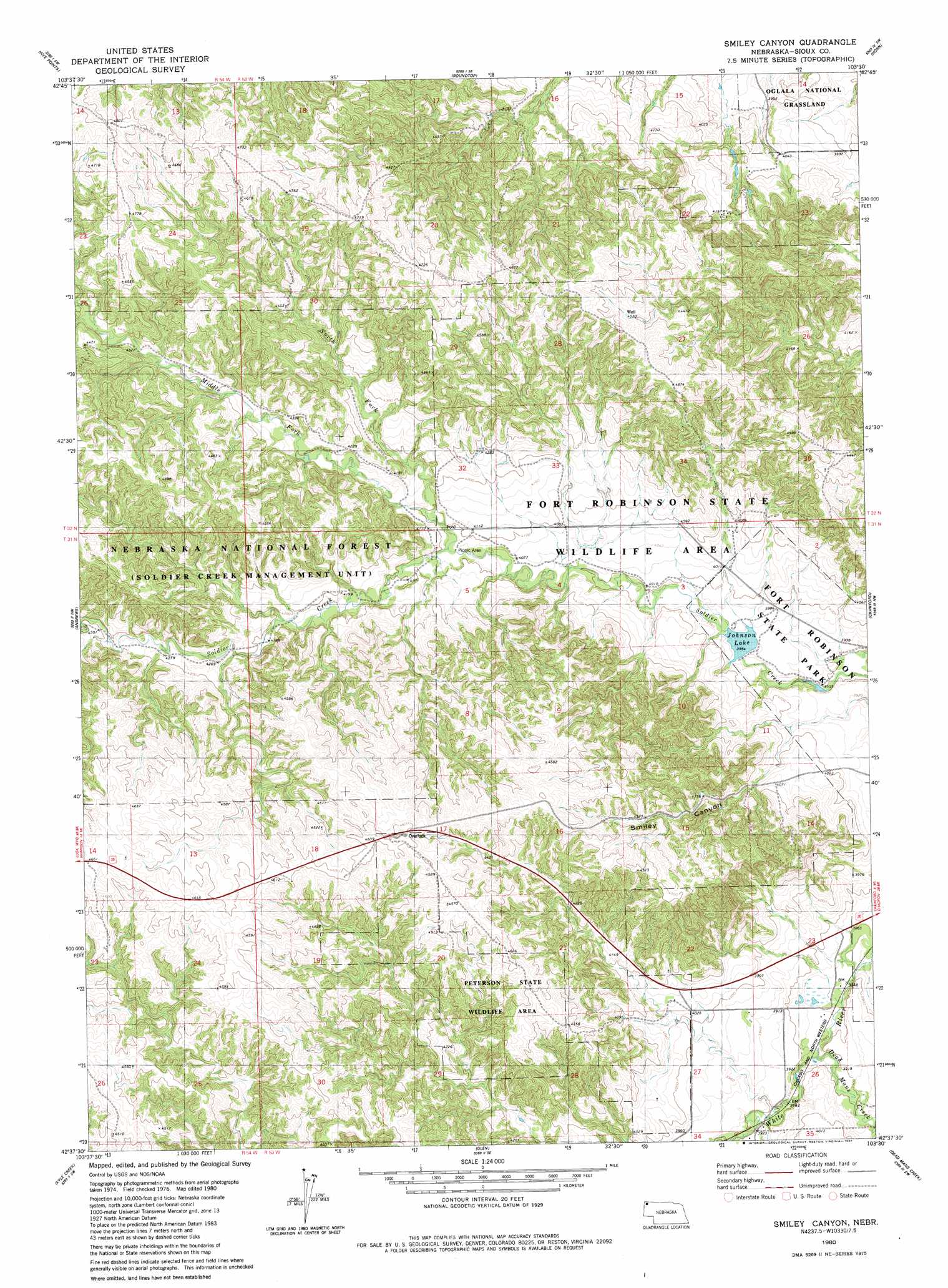
Smiley Canyon Topo Map Nebraska
To zoom in, hover over the map of Smiley Canyon
USGS Topo Quad 42103f5 - 1:24,000 scale
| Topo Map Name: | Smiley Canyon |
| USGS Topo Quad ID: | 42103f5 |
| Print Size: | ca. 21 1/4" wide x 27" high |
| Southeast Coordinates: | 42.625° N latitude / 103.5° W longitude |
| Map Center Coordinates: | 42.6875° N latitude / 103.5625° W longitude |
| U.S. State: | NE |
| Filename: | O42103F5.jpg |
| Download Map JPG Image: | Smiley Canyon topo map 1:24,000 scale |
| Map Type: | Topographic |
| Topo Series: | 7.5´ |
| Map Scale: | 1:24,000 |
| Source of Map Images: | United States Geological Survey (USGS) |
| Alternate Map Versions: |
Smiley Canyon NE 1980, updated 1981 Download PDF Buy paper map Smiley Canyon NE 2011 Download PDF Buy paper map Smiley Canyon NE 2014 Download PDF Buy paper map |
| FStopo: | US Forest Service topo Smiley Canyon is available: Download FStopo PDF Download FStopo TIF |
1:24,000 Topo Quads surrounding Smiley Canyon
Story Ne |
Montrose |
Orella |
Wolf Butte |
Lone Tree Ranch |
Bodarc |
Five Points |
Roundtop |
Horn |
Whitney |
Harrison East |
Andrews |
Smiley Canyon |
Crawford |
Crow Butte |
Harrison Se |
Kyle Creek |
Glen |
Dead Mans Creek |
Belmont |
Agate |
Whistle Creek Nw |
Whistle Creek Ne |
Marsland Nw |
Marsland Ne |
> Back to 42103e1 at 1:100,000 scale
> Back to 42102a1 at 1:250,000 scale
> Back to U.S. Topo Maps home
Smiley Canyon topo map: Gazetteer
Smiley Canyon: Dams
Boardgate Dam elevation 1197m 3927′Carter P Johnson Dam elevation 1203m 3946′
Dunlap Dam elevation 1216m 3989′
Meng Reservoir Dam elevation 1416m 4645′
Smiley Canyon: Lakes
Carter P Johnson Lake elevation 1203m 3946′Smiley Canyon: Parks
Fort Robinson State Park elevation 1203m 3946′Fort Robinson Wildlife Area elevation 1366m 4481′
Peterson State Special Use Area elevation 1323m 4340′
Smiley Canyon: Reservoirs
Boardgate Reservoir elevation 1197m 3927′Carter P Johnson Reservoir elevation 1203m 3946′
Dunlap Reservoir elevation 1216m 3989′
Meng Reservoir elevation 1416m 4645′
Smiley Canyon: Streams
Dead Mans Creek elevation 1178m 3864′Middle Fork Soldier Creek elevation 1238m 4061′
North Fork Soldier Creek elevation 1245m 4084′
South Fork Soldier Creek elevation 1238m 4061′
Smiley Canyon: Trails
Boots and Saddle Trail elevation 1333m 4373′Trooper Trail elevation 1409m 4622′
Smiley Canyon: Valleys
Smiley Canyon elevation 1235m 4051′Smiley Canyon digital topo map on disk
Buy this Smiley Canyon topo map showing relief, roads, GPS coordinates and other geographical features, as a high-resolution digital map file on DVD:
Eastern Wyoming & Western South Dakota
Buy digital topo maps: Eastern Wyoming & Western South Dakota