Shepherds Point Topo Map Wyoming
To zoom in, hover over the map of Shepherds Point
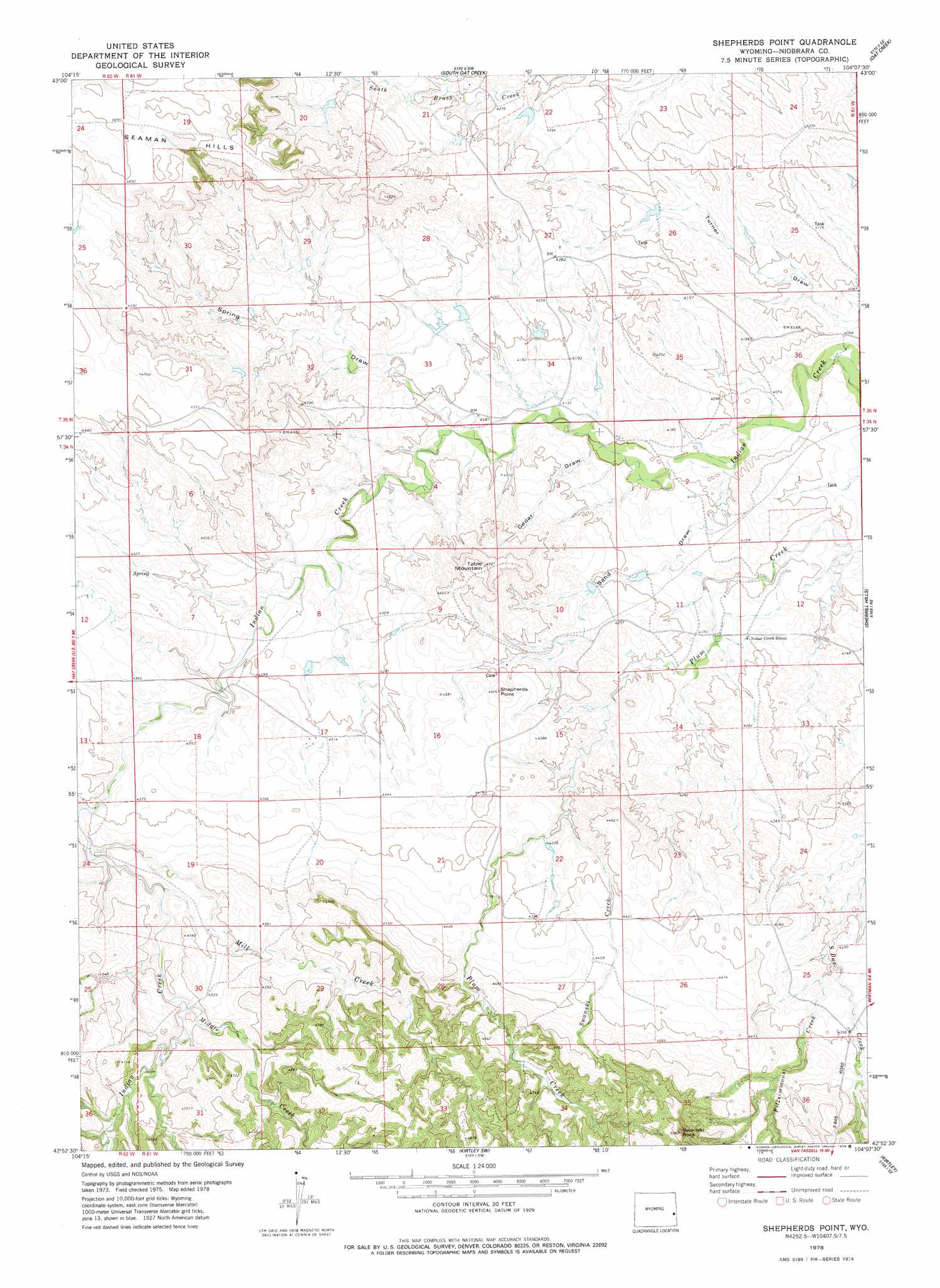
USGS Topo Quad 42104h2 - 1:24,000 scale
| Topo Map Name: | Shepherds Point |
| USGS Topo Quad ID: | 42104h2 |
| Print Size: | ca. 21 1/4" wide x 27" high |
| Southeast Coordinates: | 42.875° N latitude / 104.125° W longitude |
| Map Center Coordinates: | 42.9375° N latitude / 104.1875° W longitude |
| U.S. State: | WY |
| Filename: | o42104h2.jpg |
| Download Map JPG Image: | Shepherds Point topo map 1:24,000 scale |
| Map Type: | Topographic |
| Topo Series: | 7.5´ |
| Map Scale: | 1:24,000 |
| Source of Map Images: | United States Geological Survey (USGS) |
| Alternate Map Versions: |
Shepherds Point WY 1978, updated 1979 Download PDF Buy paper map Shepherds Point WY 2012 Download PDF Buy paper map Shepherds Point WY 2015 Download PDF Buy paper map |
1:24,000 Topo Quads surrounding Shepherds Point
Buck Creek Hills |
Redbird |
Oat Creek Nw |
Coffee Flats |
Phister Ranch |
Telephone Draw |
Coyote Gap |
South Oat Creek |
Oat Creek |
Wallace Ranch |
Hat Rock |
Hat Creek |
Shepherds Point |
Sherrill Hills |
Story |
Lusk |
Signature Rock |
Kirtley Sw |
Kirtley |
Warbonnet Ranch |
Reynolds Spring |
Node |
Mcmaster Reservoir |
Van Tassell |
Harrison West |
> Back to 42104e1 at 1:100,000 scale
> Back to 42104a1 at 1:250,000 scale
> Back to U.S. Topo Maps home
Shepherds Point topo map: Gazetteer
Shepherds Point: Cliffs
The Point elevation 1333m 4373′Shepherds Point: Dams
Clifton Number 1 Dam elevation 1269m 4163′Thomas Dam elevation 1359m 4458′
Thompson Dam elevation 1310m 4297′
Thompson Number 2 Dam elevation 1309m 4294′
Shepherds Point: Ranges
Seaman Hills elevation 1428m 4685′Shepherds Point: Reservoirs
Clifton Number 1 Reservoir elevation 1269m 4163′Thomas Reservoir elevation 1359m 4458′
Thompson Number 2 Reservoir elevation 1309m 4294′
Thompson Reservoir elevation 1310m 4297′
Shepherds Point: Streams
Fitzsimmons Creek elevation 1311m 4301′Middle Creek elevation 1360m 4461′
Mill Creek elevation 1335m 4379′
Swanski Creek elevation 1311m 4301′
Shepherds Point: Summits
Shepherds Point elevation 1333m 4373′Swanski Rock elevation 1540m 5052′
Table Mountain elevation 1376m 4514′
Three Tubs elevation 1338m 4389′
Shepherds Point: Valleys
Cedar Draw elevation 1250m 4101′Sand Draw elevation 1242m 4074′
Spring Draw elevation 1263m 4143′
Shepherds Point digital topo map on disk
Buy this Shepherds Point topo map showing relief, roads, GPS coordinates and other geographical features, as a high-resolution digital map file on DVD:
Eastern Wyoming & Western South Dakota
Buy digital topo maps: Eastern Wyoming & Western South Dakota