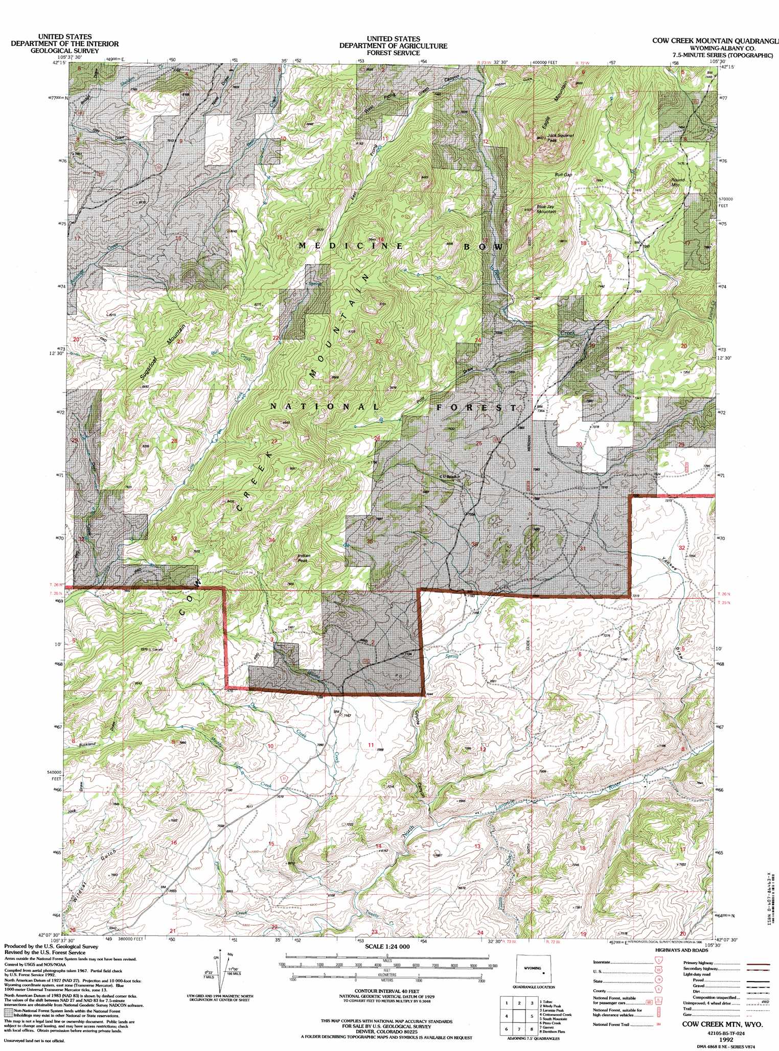
Cow Creek Mountain Topo Map Wyoming
To zoom in, hover over the map of Cow Creek Mountain
USGS Topo Quad 42105b5 - 1:24,000 scale
| Topo Map Name: | Cow Creek Mountain |
| USGS Topo Quad ID: | 42105b5 |
| Print Size: | ca. 21 1/4" wide x 27" high |
| Southeast Coordinates: | 42.125° N latitude / 105.5° W longitude |
| Map Center Coordinates: | 42.1875° N latitude / 105.5625° W longitude |
| U.S. State: | WY |
| Filename: | o42105b5.jpg |
| Download Map JPG Image: | Cow Creek Mountain topo map 1:24,000 scale |
| Map Type: | Topographic |
| Topo Series: | 7.5´ |
| Map Scale: | 1:24,000 |
| Source of Map Images: | United States Geological Survey (USGS) |
| Alternate Map Versions: |
Cow Creek Mountain WY 1968, updated 1972 Download PDF Buy paper map Cow Creek Mountain WY 1968, updated 1985 Download PDF Buy paper map Cow Creek Mtn WY 1992, updated 1996 Download PDF Buy paper map Cow Creek Mountain WY 2012 Download PDF Buy paper map Cow Creek Mountain WY 2015 Download PDF Buy paper map |
| FStopo: | US Forest Service topo Cow Creek Mountain is available: Download FStopo PDF Download FStopo TIF |
1:24,000 Topo Quads surrounding Cow Creek Mountain
Warbonnett Peak |
School Section Mountain |
Saddleback Mountain |
Braae |
Esterbrook |
Marshall |
Toltec |
Windy Peak |
Laramie Peak |
Harris Park |
Rogers Creek |
Cottonwood Creek |
Cow Creek Mountain |
South Mountain |
Fletcher Park |
Boot Heel Se |
Pinto Creek |
Garrett |
Davidson Flats |
Reese Mountain |
Sevenmile Spring |
Ayres Spring |
Dodge Ranch |
Bull Camp Peak |
Moonshine Peak |
> Back to 42105a1 at 1:100,000 scale
> Back to 42104a1 at 1:250,000 scale
> Back to U.S. Topo Maps home
Cow Creek Mountain topo map: Gazetteer
Cow Creek Mountain: Gaps
Bull Gap elevation 2361m 7746′Cow Creek Mountain: Streams
Bull Creek elevation 2387m 7831′Deer Creek elevation 2277m 7470′
Friend Creek elevation 2119m 6952′
Muddy Ford Creek elevation 2114m 6935′
Owl Creek elevation 2135m 7004′
Pine Creek elevation 2037m 6683′
Potato Creek elevation 1999m 6558′
Tweety Creek elevation 2024m 6640′
Willow Creek elevation 2020m 6627′
Cow Creek Mountain: Summits
Blue Jay Mountain elevation 2466m 8090′Cow Creek Mountain elevation 2619m 8592′
Eagle Mountain elevation 2699m 8854′
Indian Peak elevation 2444m 8018′
Jack Squirrel Peak elevation 2699m 8854′
Round Mountain elevation 2394m 7854′
Sugarloaf Mountain elevation 2571m 8435′
Cow Creek Mountain: Valleys
Bridge Draw elevation 2352m 7716′Coyote Canyon elevation 2011m 6597′
East Prong Green Canyon elevation 2285m 7496′
Green Canyon elevation 2253m 7391′
Hidden Gulch elevation 2281m 7483′
Pole Draw elevation 2177m 7142′
West Prong Green Canyon elevation 2285m 7496′
Yankee Draw elevation 1975m 6479′
Cow Creek Mountain digital topo map on disk
Buy this Cow Creek Mountain topo map showing relief, roads, GPS coordinates and other geographical features, as a high-resolution digital map file on DVD:
Eastern Wyoming & Western South Dakota
Buy digital topo maps: Eastern Wyoming & Western South Dakota