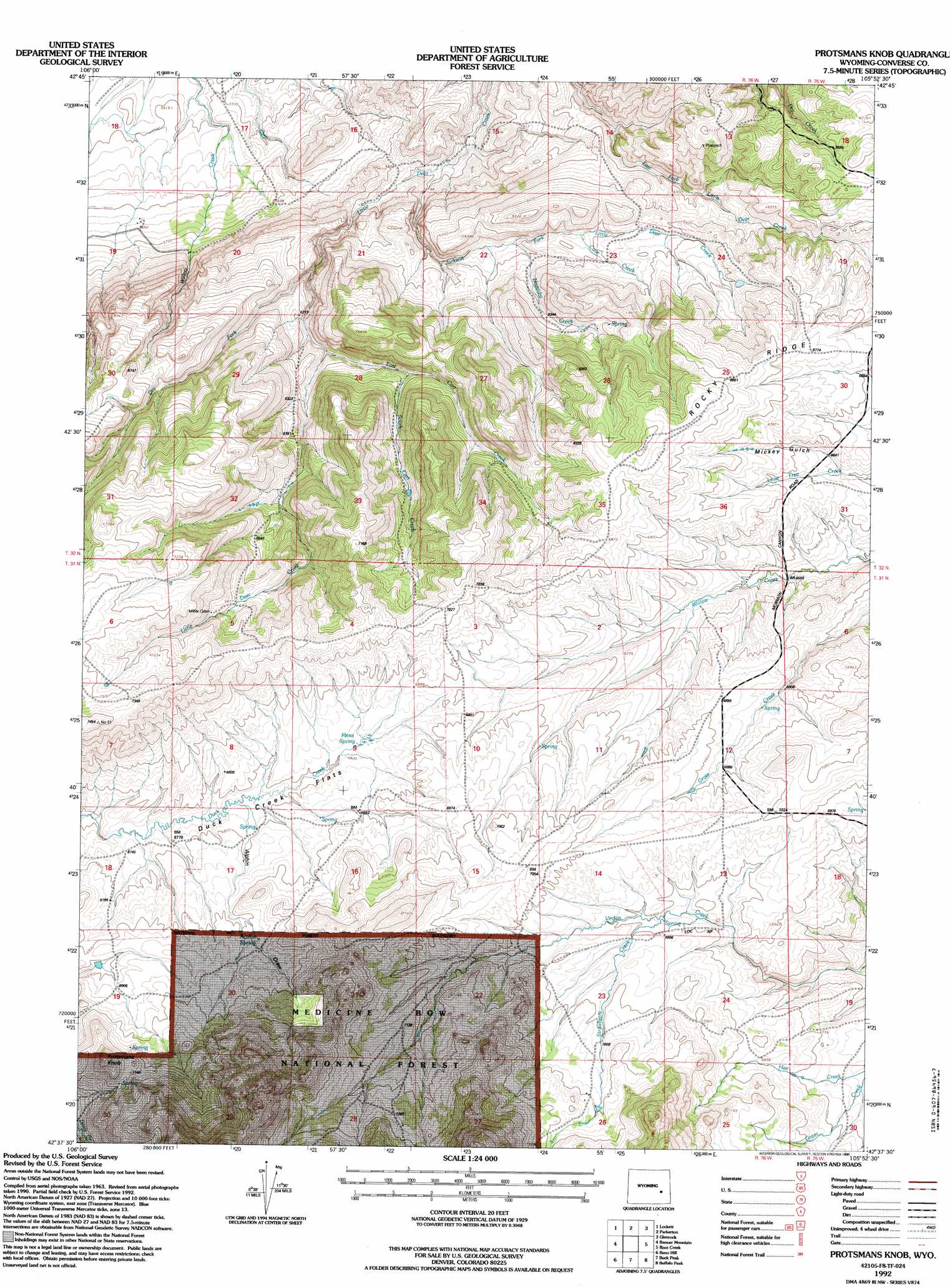
Protsmans Knob Topo Map Wyoming
To zoom in, hover over the map of Protsmans Knob
USGS Topo Quad 42105f8 - 1:24,000 scale
| Topo Map Name: | Protsmans Knob |
| USGS Topo Quad ID: | 42105f8 |
| Print Size: | ca. 21 1/4" wide x 27" high |
| Southeast Coordinates: | 42.625° N latitude / 105.875° W longitude |
| Map Center Coordinates: | 42.6875° N latitude / 105.9375° W longitude |
| U.S. State: | WY |
| Filename: | o42105f8.jpg |
| Download Map JPG Image: | Protsmans Knob topo map 1:24,000 scale |
| Map Type: | Topographic |
| Topo Series: | 7.5´ |
| Map Scale: | 1:24,000 |
| Source of Map Images: | United States Geological Survey (USGS) |
| Alternate Map Versions: |
Protsmans Knob WY 1964, updated 1968 Download PDF Buy paper map Protsmans Knob WY 1964, updated 1985 Download PDF Buy paper map Protsmans Knob WY 1992, updated 1996 Download PDF Buy paper map Protsmans Knob WY 2012 Download PDF Buy paper map Protsmans Knob WY 2015 Download PDF Buy paper map |
| FStopo: | US Forest Service topo Protsmans Knob is available: Download FStopo PDF Download FStopo TIF |
1:24,000 Topo Quads surrounding Protsmans Knob
Pratts Soda Lakes |
Campbell Hill |
Glenrock Nw |
Hylton Ranch |
Leuenberger Ranch |
Brookhurst |
Lockett |
Parkerton |
Glenrock |
Careyhurst |
Otter Creek |
Banner Mountain |
Protsmans Knob |
Root Creek |
Hermit Rock |
Ice Cave Mountain |
Reno Hill |
Buck Peak |
Buffalo Peak |
Blue Nose Creek |
Bates Creek Reservoir |
Squaw Spring |
Rock Creek |
Warbonnett Peak |
School Section Mountain |
> Back to 42105e1 at 1:100,000 scale
> Back to 42104a1 at 1:250,000 scale
> Back to U.S. Topo Maps home
Protsmans Knob topo map: Gazetteer
Protsmans Knob: Flats
Duck Creek Flats elevation 2066m 6778′Protsmans Knob: Mines
Lucky Lode Claim elevation 1971m 6466′McCoun, Wells and Rhoads Deposit elevation 1971m 6466′
Smith Deposit elevation 1881m 6171′
Swede Boy Mine elevation 2127m 6978′
Protsmans Knob: Ridges
Rocky Ridge elevation 2105m 6906′Protsmans Knob: Springs
Alphin Spring elevation 2109m 6919′Mesa Spring elevation 2079m 6820′
Protsmans Knob: Streams
Cave Creek elevation 1907m 6256′Dry Fork elevation 1838m 6030′
East Cart Creek elevation 1886m 6187′
Hay Creek elevation 2050m 6725′
Jackson Fork Little Deer Creek elevation 1753m 5751′
Nagyidai Creek elevation 1876m 6154′
South Cart Creek elevation 1926m 6318′
Strawberry Creek elevation 2096m 6876′
Protsmans Knob: Summits
Protsmans Knob elevation 2243m 7358′Protsmans Knob: Valleys
Alphin Draw elevation 2061m 6761′Mickey Gulch elevation 2017m 6617′
Protsmans Knob digital topo map on disk
Buy this Protsmans Knob topo map showing relief, roads, GPS coordinates and other geographical features, as a high-resolution digital map file on DVD:
Eastern Wyoming & Western South Dakota
Buy digital topo maps: Eastern Wyoming & Western South Dakota