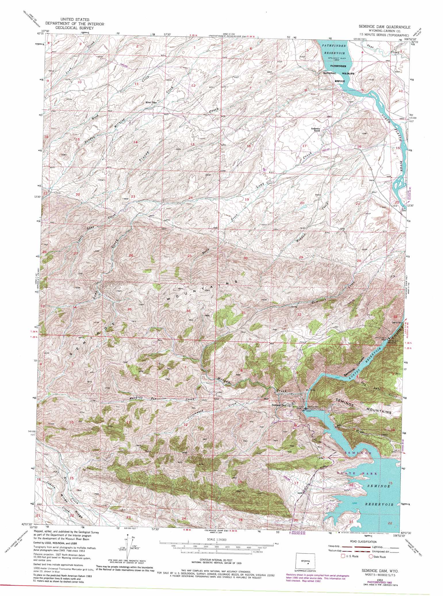
Seminoe Dam Topo Map Wyoming
To zoom in, hover over the map of Seminoe Dam
USGS Topo Quad 42106b8 - 1:24,000 scale
| Topo Map Name: | Seminoe Dam |
| USGS Topo Quad ID: | 42106b8 |
| Print Size: | ca. 21 1/4" wide x 27" high |
| Southeast Coordinates: | 42.125° N latitude / 106.875° W longitude |
| Map Center Coordinates: | 42.1875° N latitude / 106.9375° W longitude |
| U.S. State: | WY |
| Filename: | o42106b8.jpg |
| Download Map JPG Image: | Seminoe Dam topo map 1:24,000 scale |
| Map Type: | Topographic |
| Topo Series: | 7.5´ |
| Map Scale: | 1:24,000 |
| Source of Map Images: | United States Geological Survey (USGS) |
| Alternate Map Versions: |
Seminoe Dam WY 1953, updated 1955 Download PDF Buy paper map Seminoe Dam WY 1953, updated 1968 Download PDF Buy paper map Seminoe Dam WY 1953, updated 1983 Download PDF Buy paper map Seminoe Dam WY 1953, updated 1983 Download PDF Buy paper map Seminoe Dam WY 2012 Download PDF Buy paper map Seminoe Dam WY 2015 Download PDF Buy paper map |
1:24,000 Topo Quads surrounding Seminoe Dam
Independence Rock |
Fort Ridge |
Pathfinder Reservoir Nw |
Pathfinder Dam |
Bear Spring |
Spanish Mine |
Buzzard Ranch |
Pathfinder Reservoir Sw |
Leo |
Fourmile Ridge |
Ferris |
Bradley Peak |
Seminoe Dam |
Seminoe Dam Ne |
Beaver Creek |
Riddle Cut |
Wild Horse Mountain |
Seminoe Dam Sw |
Seminoe Dam Se |
Schneider Ridge |
Rawlins Nw |
Lone Haystack Mountain |
Ferris Lake |
Pats Bottom |
Tenmile Spring |
> Back to 42106a1 at 1:100,000 scale
> Back to 42106a1 at 1:250,000 scale
> Back to U.S. Topo Maps home
Seminoe Dam topo map: Gazetteer
Seminoe Dam: Dams
Kortes Dam elevation 1831m 6007′Kortes Dam elevation 2090m 6856′
Seminoe Dam elevation 1939m 6361′
Seminoe Dam: Mines
Charlies Glory Hole Mine elevation 1936m 6351′Seminoe Dam Mine elevation 2134m 7001′
Seminoe Mountains Mine elevation 2121m 6958′
Seminoe Dam: Populated Places
Seminoe Dam elevation 2078m 6817′Seminoe Dam: Reservoirs
Kortes Reservoir elevation 2090m 6856′Kortes Reservoir elevation 1827m 5994′
Seminoe Reservoir elevation 1939m 6361′
Seminoe Dam: Streams
Cottonwood Creek elevation 1970m 6463′Dry Lake Creek elevation 1893m 6210′
Gooseberry Creek elevation 1793m 5882′
Little Long Creek elevation 2006m 6581′
Long Creek elevation 1785m 5856′
Marking Pen Creek elevation 2055m 6742′
Meadow Creek elevation 1808m 5931′
Morgan Creek elevation 1875m 6151′
Tincup Creek elevation 1784m 5853′
Seminoe Dam digital topo map on disk
Buy this Seminoe Dam topo map showing relief, roads, GPS coordinates and other geographical features, as a high-resolution digital map file on DVD:
Eastern Wyoming & Western South Dakota
Buy digital topo maps: Eastern Wyoming & Western South Dakota