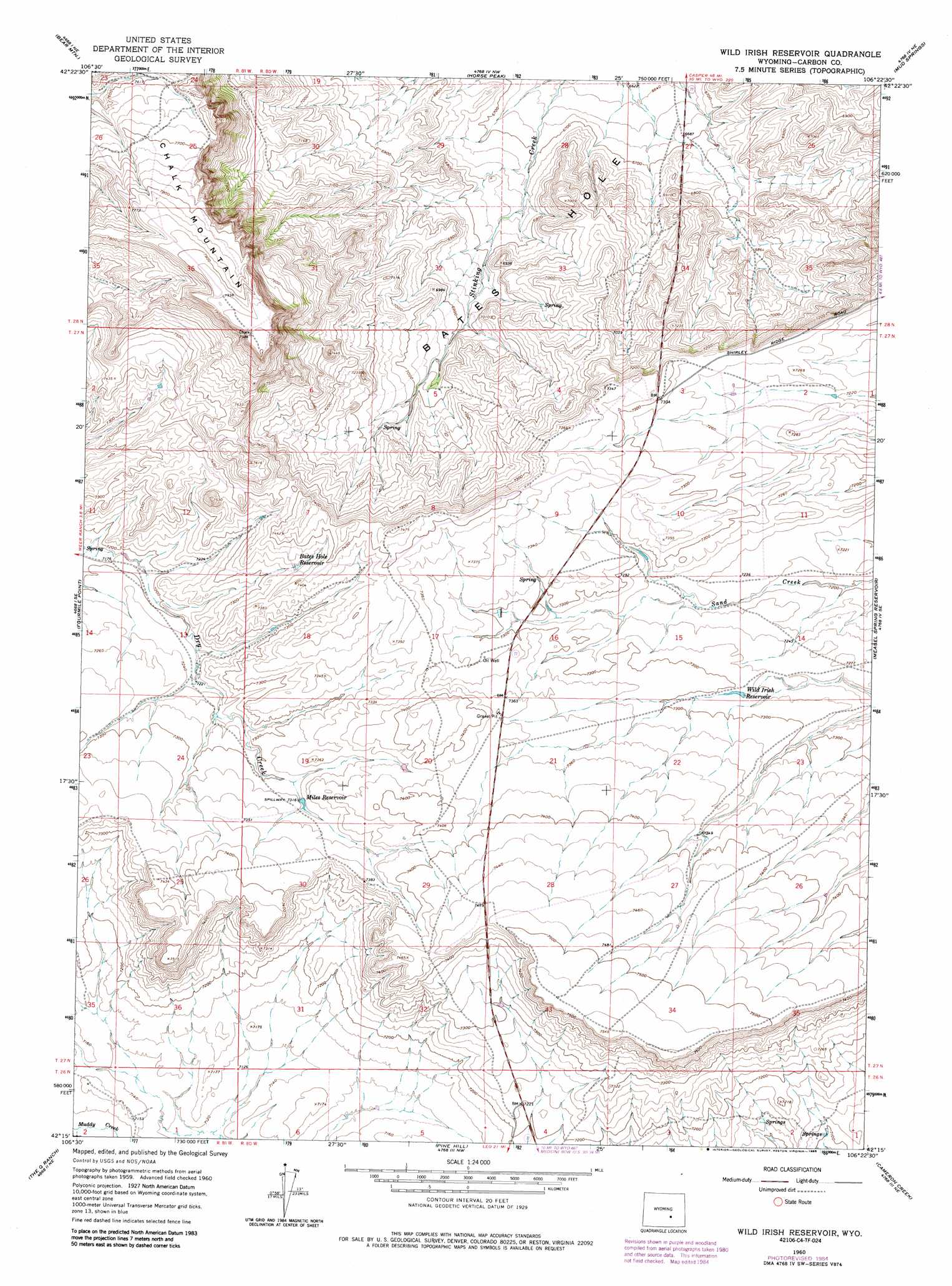
Wild Irish Reservoir Topo Map Wyoming
To zoom in, hover over the map of Wild Irish Reservoir
USGS Topo Quad 42106c4 - 1:24,000 scale
| Topo Map Name: | Wild Irish Reservoir |
| USGS Topo Quad ID: | 42106c4 |
| Print Size: | ca. 21 1/4" wide x 27" high |
| Southeast Coordinates: | 42.25° N latitude / 106.375° W longitude |
| Map Center Coordinates: | 42.3125° N latitude / 106.4375° W longitude |
| U.S. State: | WY |
| Filename: | o42106c4.jpg |
| Download Map JPG Image: | Wild Irish Reservoir topo map 1:24,000 scale |
| Map Type: | Topographic |
| Topo Series: | 7.5´ |
| Map Scale: | 1:24,000 |
| Source of Map Images: | United States Geological Survey (USGS) |
| Alternate Map Versions: |
Wild Irish Reservoir WY 1960, updated 1964 Download PDF Buy paper map Wild Irish Reservoir WY 1960, updated 1985 Download PDF Buy paper map Wild Irish Reservoir WY 2012 Download PDF Buy paper map Wild Irish Reservoir WY 2015 Download PDF Buy paper map |
1:24,000 Topo Quads surrounding Wild Irish Reservoir
Alcova |
Alcova Se |
Twin Buttes |
Sheep Creek |
Ice Cave Mountain |
Bear Spring |
Bear Mountain |
Horse Peak |
Mud Springs |
Bates Creek Reservoir |
Fourmile Ridge |
Fourmile Point |
Wild Irish Reservoir |
Measel Spring Reservoir |
Moss Agate Reservoir |
Beaver Creek |
The Q Ranch |
Pine Hill |
Cameron Creek |
Walker Draw Nw |
Schneider Ridge |
T E Ranch |
Difficulty |
Windy Hill |
T B Ranch |
> Back to 42106a1 at 1:100,000 scale
> Back to 42106a1 at 1:250,000 scale
> Back to U.S. Topo Maps home
Wild Irish Reservoir topo map: Gazetteer
Wild Irish Reservoir: Reservoirs
Bates Hole Reservoir elevation 2238m 7342′Miles Reservoir elevation 2231m 7319′
Wild Irish Reservoir elevation 2221m 7286′
Wild Irish Reservoir: Summits
Chalk Mountain elevation 2434m 7985′Wild Irish Reservoir digital topo map on disk
Buy this Wild Irish Reservoir topo map showing relief, roads, GPS coordinates and other geographical features, as a high-resolution digital map file on DVD:
Eastern Wyoming & Western South Dakota
Buy digital topo maps: Eastern Wyoming & Western South Dakota