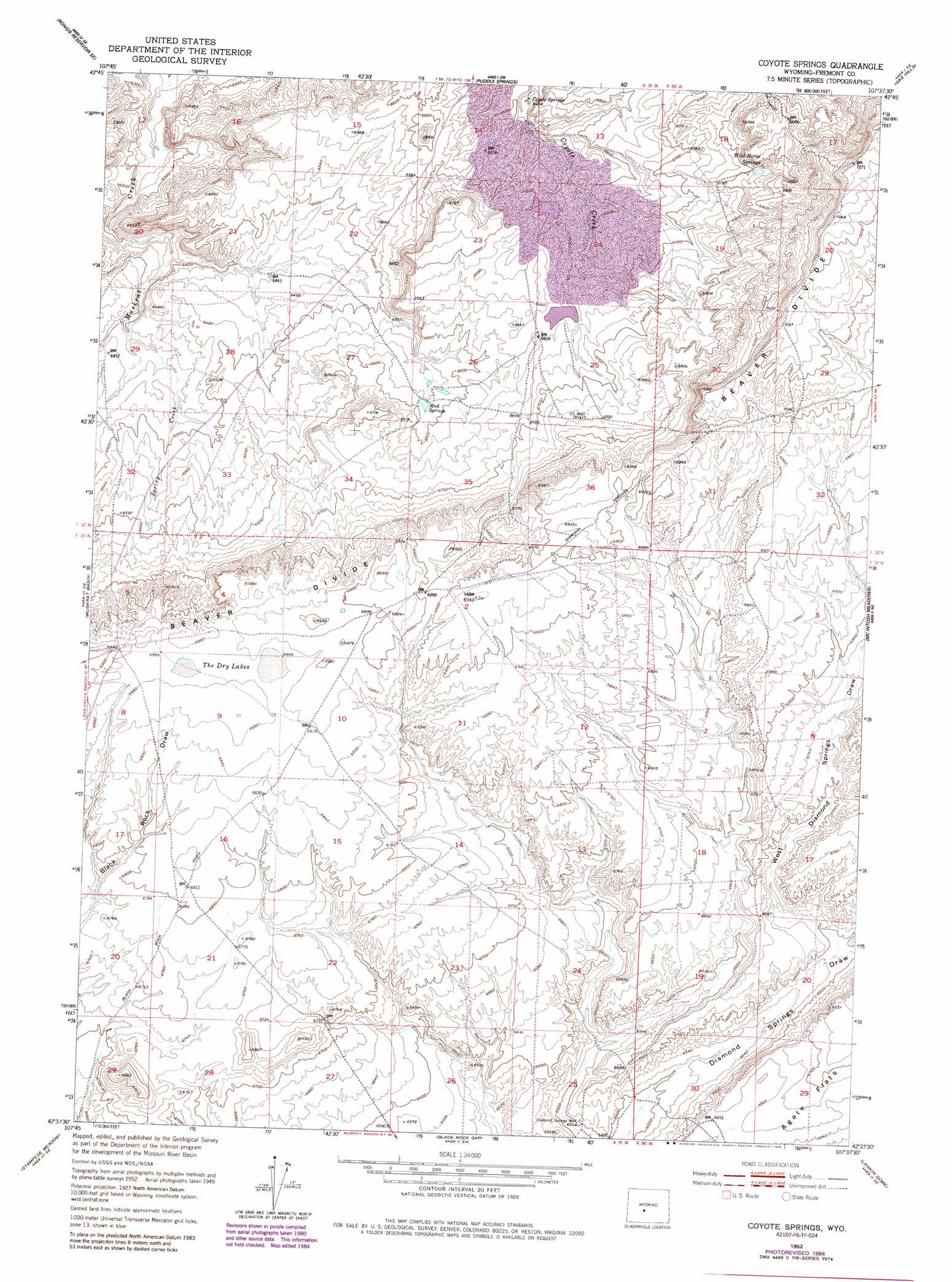
Coyote Springs Topo Map Wyoming
To zoom in, hover over the map of Coyote Springs
USGS Topo Quad 42107f6 - 1:24,000 scale
| Topo Map Name: | Coyote Springs |
| USGS Topo Quad ID: | 42107f6 |
| Print Size: | ca. 21 1/4" wide x 27" high |
| Southeast Coordinates: | 42.625° N latitude / 107.625° W longitude |
| Map Center Coordinates: | 42.6875° N latitude / 107.6875° W longitude |
| U.S. State: | WY |
| Filename: | o42107f6.jpg |
| Download Map JPG Image: | Coyote Springs topo map 1:24,000 scale |
| Map Type: | Topographic |
| Topo Series: | 7.5´ |
| Map Scale: | 1:24,000 |
| Source of Map Images: | United States Geological Survey (USGS) |
| Alternate Map Versions: |
Coyote Springs WY 1952, updated 1953 Download PDF Buy paper map Coyote Springs WY 1952, updated 1965 Download PDF Buy paper map Coyote Springs WY 1952, updated 1984 Download PDF Buy paper map Coyote Springs WY 1952, updated 1985 Download PDF Buy paper map Coyote Springs WY 2012 Download PDF Buy paper map Coyote Springs WY 2015 Download PDF Buy paper map |
1:24,000 Topo Quads surrounding Coyote Springs
Double Butte |
Butte Well |
Love Ranch |
Miles Ranch |
Ervay Basin |
Rongis Reservoir |
Rongis Reservoir Se |
Puddle Springs |
Gas Hills |
Ervay Basin Sw |
Tin Cup Mountain |
Muskrat Basin |
Coyote Springs |
Mcintosh Meadows |
Blackjack Ranch |
Graham Ranch |
Stampede Meadow |
Black Rock Gap |
Lankin Dome |
Lone Mountain |
Crooks Mountain |
Jeffrey City |
Split Rock Nw |
Split Rock |
Bucklin Reservoirs |
> Back to 42107e1 at 1:100,000 scale
> Back to 42106a1 at 1:250,000 scale
> Back to U.S. Topo Maps home
Coyote Springs topo map: Gazetteer
Coyote Springs: Dams
Day Ore Pad Dam elevation 2024m 6640′Day South Dam elevation 2076m 6811′
East Dam elevation 2038m 6686′
Coyote Springs: Lakes
The Dry Lakes elevation 2096m 6876′Coyote Springs: Mines
B. T. W. Number Eighteen Mine elevation 2014m 6607′Bum Steer Number One Mine elevation 1984m 6509′
Clyde Bret Mine elevation 2002m 6568′
Clyde Mine elevation 1989m 6525′
Clyde Mines elevation 2047m 6715′
Clyde Number Five Mine elevation 2046m 6712′
Clyde Number Three Mine elevation 2046m 6712′
Clyde, A, B, A-1, A2C Mine elevation 2025m 6643′
Coco Underground Number One Mine elevation 2047m 6715′
Day Mine elevation 2007m 6584′
Day Number Twenty-six Mine elevation 2033m 6669′
Federal American Open Pit elevation 1999m 6558′
Keeno Number One Mine elevation 2018m 6620′
Loco Bret A2C, C-2 Number One Mine elevation 2045m 6709′
Loco C Mine elevation 2001m 6564′
Loco D Mine elevation 2006m 6581′
Loco M, L, K Mine elevation 1998m 6555′
Loco N-1, N-2 Mine elevation 1985m 6512′
Loma Mine Group elevation 2016m 6614′
Loma-Day Claims elevation 2006m 6581′
Nels Number Eight Mine elevation 2015m 6610′
Nels Number Twenty Mine elevation 2102m 6896′
Reno Number One Mine elevation 2015m 6610′
RMCC Number Eight Mine elevation 1990m 6528′
Coyote Springs: Reservoirs
Day Ore Pad Reservoir elevation 2024m 6640′Day South Reservoir elevation 2076m 6811′
East Reservoir elevation 2038m 6686′
Coyote Springs: Springs
Coyote Springs elevation 1970m 6463′Mud Springs elevation 2011m 6597′
Wild Horse Springs elevation 2096m 6876′
Coyote Springs: Streams
Spring Creek elevation 1957m 6420′Coyote Springs: Valleys
West Diamond Springs Draw elevation 2009m 6591′Coyote Springs: Wells
Diamond Springs Well elevation 1984m 6509′Coyote Springs digital topo map on disk
Buy this Coyote Springs topo map showing relief, roads, GPS coordinates and other geographical features, as a high-resolution digital map file on DVD:
Eastern Wyoming & Western South Dakota
Buy digital topo maps: Eastern Wyoming & Western South Dakota