Atlantic City Topo Map Wyoming
To zoom in, hover over the map of Atlantic City
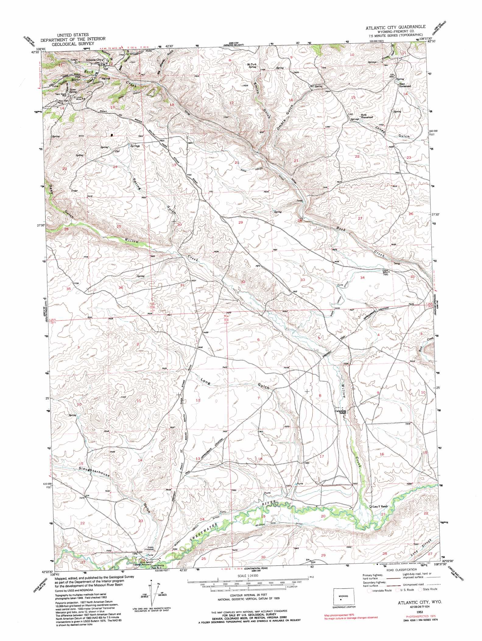
USGS Topo Quad 42108d6 - 1:24,000 scale
| Topo Map Name: | Atlantic City |
| USGS Topo Quad ID: | 42108d6 |
| Print Size: | ca. 21 1/4" wide x 27" high |
| Southeast Coordinates: | 42.375° N latitude / 108.625° W longitude |
| Map Center Coordinates: | 42.4375° N latitude / 108.6875° W longitude |
| U.S. State: | WY |
| Filename: | o42108d6.jpg |
| Download Map JPG Image: | Atlantic City topo map 1:24,000 scale |
| Map Type: | Topographic |
| Topo Series: | 7.5´ |
| Map Scale: | 1:24,000 |
| Source of Map Images: | United States Geological Survey (USGS) |
| Alternate Map Versions: |
Atlantic City WY 1953, updated 1955 Download PDF Buy paper map Atlantic City WY 1953, updated 1963 Download PDF Buy paper map Atlantic City WY 1953, updated 1991 Download PDF Buy paper map Atlantic City WY 2012 Download PDF Buy paper map Atlantic City WY 2015 Download PDF Buy paper map |
1:24,000 Topo Quads surrounding Atlantic City
Cony Mountain |
Fossil Hill |
Wolf Point |
Weiser Pass |
Del Monte Ridge |
Christina Lake |
Louis Lake |
Miners Delight |
Gravel Spring |
Schoettlin Mountain |
Anderson Ridge |
South Pass City |
Atlantic City |
Radium Springs |
Lewiston Lakes |
Pacific Springs |
Dickie Springs |
Continental Peak |
Circle Bar Lake |
Picket Lake |
Rock Cabin Spring |
Joe Hay Rim |
Bob Jack Well |
John Hay Reservoir |
Five Fingers Butte |
> Back to 42108a1 at 1:100,000 scale
> Back to 42108a1 at 1:250,000 scale
> Back to U.S. Topo Maps home
Atlantic City topo map: Gazetteer
Atlantic City: Canals
Beaver Dam Ditch elevation 2220m 7283′Burnt Ranch Ditch elevation 2225m 7299′
Rock Creek Ditch elevation 2293m 7522′
Atlantic City: Mines
Mary Ellen Mine elevation 2466m 8090′Mechanic and Emerald Lode elevation 2388m 7834′
Saint Louis Mines elevation 2454m 8051′
Tabor Grand Mine elevation 2418m 7933′
Atlantic City: Populated Places
Atlantic City elevation 2344m 7690′Last Crossing Ford Number 9 elevation 2225m 7299′
Atlantic City: Springs
McTurk Spring elevation 2358m 7736′Tabor Spring elevation 2422m 7946′
Atlantic City: Streams
Little Beaver Creek elevation 2338m 7670′Oregon Slough elevation 2225m 7299′
Willow Creek elevation 2208m 7244′
Atlantic City: Valleys
Anthony Gulch elevation 2341m 7680′Baltic Gulch elevation 2373m 7785′
Basket Gulch elevation 2385m 7824′
Beer Garden Gulch elevation 2336m 7664′
Big Atlantic Gulch elevation 2315m 7595′
Buckeye Gulch elevation 2381m 7811′
Deep Gulch elevation 2303m 7555′
Little Atlantic Gulch elevation 2338m 7670′
Long Gulch elevation 2220m 7283′
Omara Gulch elevation 2279m 7477′
Slaughterhouse Gulch elevation 2229m 7312′
Smith Gulch elevation 2284m 7493′
Spring Gulch elevation 2274m 7460′
Tabor Gulch elevation 2391m 7844′
Atlantic City digital topo map on disk
Buy this Atlantic City topo map showing relief, roads, GPS coordinates and other geographical features, as a high-resolution digital map file on DVD: