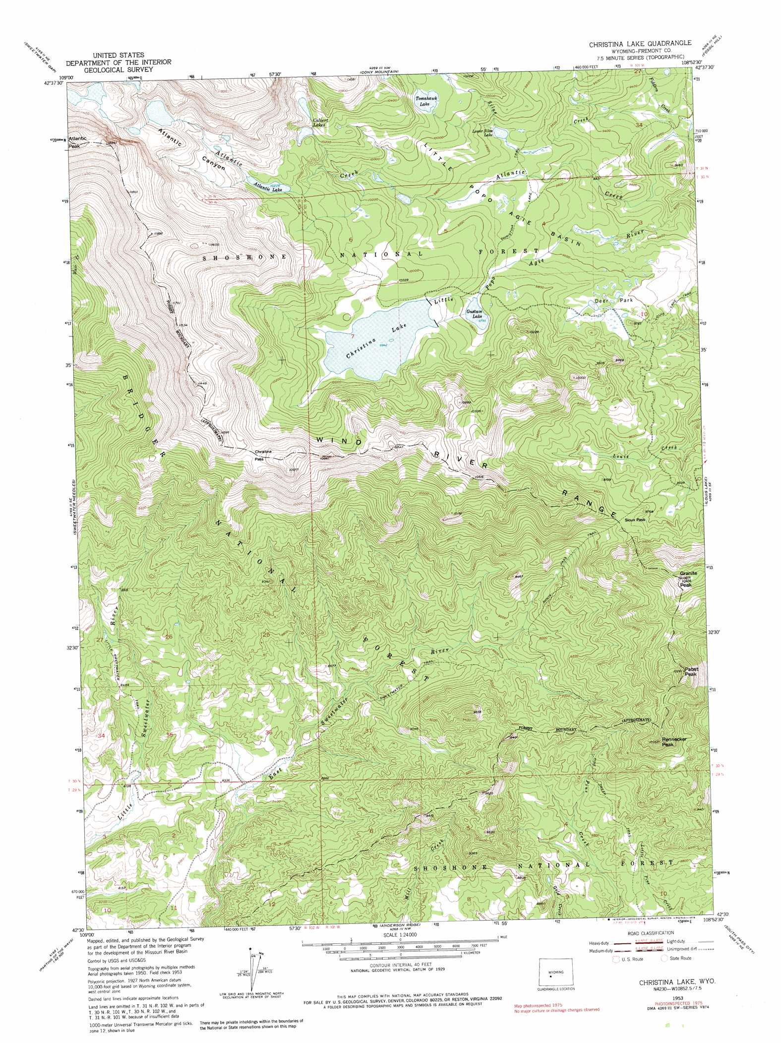
Christina Lake Topo Map Wyoming
To zoom in, hover over the map of Christina Lake
USGS Topo Quad 42108e8 - 1:24,000 scale
| Topo Map Name: | Christina Lake |
| USGS Topo Quad ID: | 42108e8 |
| Print Size: | ca. 21 1/4" wide x 27" high |
| Southeast Coordinates: | 42.5° N latitude / 108.875° W longitude |
| Map Center Coordinates: | 42.5625° N latitude / 108.9375° W longitude |
| U.S. State: | WY |
| Filename: | o42108e8.jpg |
| Download Map JPG Image: | Christina Lake topo map 1:24,000 scale |
| Map Type: | Topographic |
| Topo Series: | 7.5´ |
| Map Scale: | 1:24,000 |
| Source of Map Images: | United States Geological Survey (USGS) |
| Alternate Map Versions: |
Christina Lake WY 1953, updated 1955 Download PDF Buy paper map Christina Lake WY 1953, updated 1965 Download PDF Buy paper map Christina Lake WY 1953, updated 1974 Download PDF Buy paper map Christina Lake WY 1991, updated 1997 Download PDF Buy paper map Christina Lake WY 2012 Download PDF Buy paper map Christina Lake WY 2015 Download PDF Buy paper map |
| FStopo: | US Forest Service topo Christina Lake is available: Download FStopo PDF Download FStopo TIF |
1:24,000 Topo Quads surrounding Christina Lake
Lizard Head Peak |
Dickinson Park |
Mount Arter |
Mount Arter Se |
Lander |
Temple Peak |
Sweetwater Gap |
Cony Mountain |
Fossil Hill |
Wolf Point |
Jensen Meadows |
Sweetwater Needles |
Christina Lake |
Louis Lake |
Miners Delight |
Prospect Mountains |
Halls Meadow Spring |
Anderson Ridge |
South Pass City |
Atlantic City |
Parting Of The Ways |
Hay Meadow Reservoir |
Pacific Springs |
Dickie Springs |
Continental Peak |
> Back to 42108e1 at 1:100,000 scale
> Back to 42108a1 at 1:250,000 scale
> Back to U.S. Topo Maps home
Christina Lake topo map: Gazetteer
Christina Lake: Basins
Little Popo Agie Basin elevation 2957m 9701′Christina Lake: Dams
Christina Dam elevation 3036m 9960′Christina Lake: Flats
Deer Park elevation 2938m 9639′Christina Lake: Gaps
Christina Pass elevation 3271m 10731′Sioux Pass elevation 2972m 9750′
Christina Lake: Lakes
Atlantic Lake elevation 3117m 10226′Calvert Lakes elevation 3149m 10331′
Gustave Lake elevation 2982m 9783′
Lower Silas Lake elevation 2958m 9704′
Tomahawk Lake elevation 3067m 10062′
Windy Lake elevation 3275m 10744′
Christina Lake: Reservoirs
Christina Lake elevation 3031m 9944′Christina Lake: Streams
Fiddlers Creek elevation 2795m 9169′Silas Creek elevation 2793m 9163′
Christina Lake: Summits
Granite Peak elevation 3170m 10400′Pabst Peak elevation 3124m 10249′
Rennecker Peak elevation 3064m 10052′
Christina Lake: Trails
Christina Lake Trail elevation 2941m 9648′Little Sweetwater Trail elevation 2579m 8461′
Pine Creek Trail elevation 2637m 8651′
Sioux Pass Trail elevation 2795m 9169′
Christina Lake: Valleys
Atlantic Canyon elevation 3134m 10282′Christina Lake digital topo map on disk
Buy this Christina Lake topo map showing relief, roads, GPS coordinates and other geographical features, as a high-resolution digital map file on DVD: