Elkhorn Springs Topo Map Wyoming
To zoom in, hover over the map of Elkhorn Springs
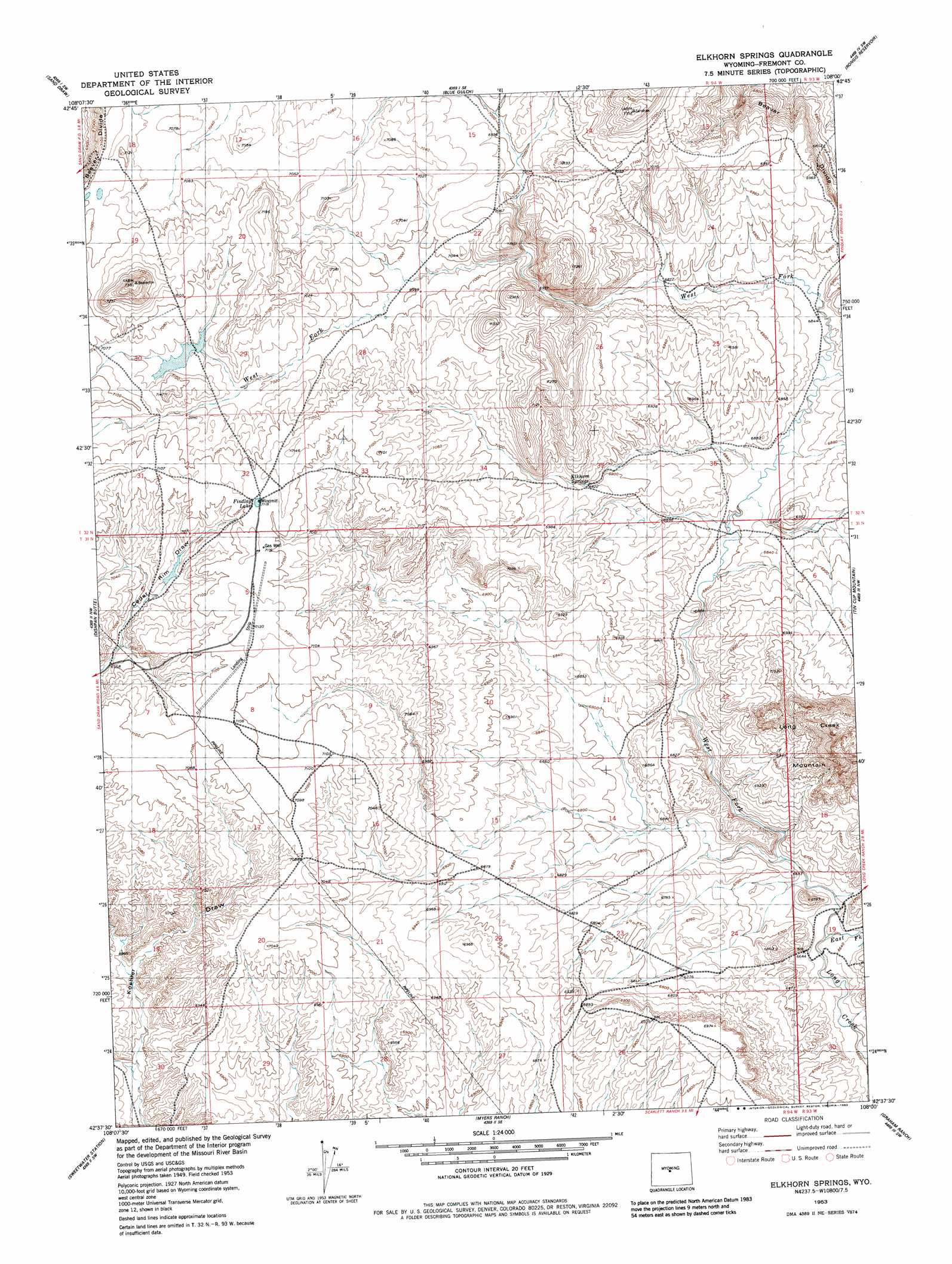
USGS Topo Quad 42108f1 - 1:24,000 scale
| Topo Map Name: | Elkhorn Springs |
| USGS Topo Quad ID: | 42108f1 |
| Print Size: | ca. 21 1/4" wide x 27" high |
| Southeast Coordinates: | 42.625° N latitude / 108° W longitude |
| Map Center Coordinates: | 42.6875° N latitude / 108.0625° W longitude |
| U.S. State: | WY |
| Filename: | o42108f1.jpg |
| Download Map JPG Image: | Elkhorn Springs topo map 1:24,000 scale |
| Map Type: | Topographic |
| Topo Series: | 7.5´ |
| Map Scale: | 1:24,000 |
| Source of Map Images: | United States Geological Survey (USGS) |
| Alternate Map Versions: |
Elkhorn Springs WY 1953, updated 1954 Download PDF Buy paper map Elkhorn Springs WY 1953, updated 1982 Download PDF Buy paper map Elkhorn Springs WY 2012 Download PDF Buy paper map Elkhorn Springs WY 2015 Download PDF Buy paper map |
1:24,000 Topo Quads surrounding Elkhorn Springs
Arapahoe Ne |
Alkali Butte |
Campbell Ridge |
Double Butte |
Butte Well |
Bringolf Ranch |
Sand Draw |
Blue Gulch |
Rongis Reservoir |
Rongis Reservoir Se |
Yellowstone Ranch |
Dishpan Butte |
Elkhorn Springs |
Tin Cup Mountain |
Muskrat Basin |
Red Canyon |
Sweetwater Station |
Myers Ranch |
Graham Ranch |
Stampede Meadow |
Barras Springs |
Happy Spring |
Soap Holes |
Crooks Mountain |
Jeffrey City |
> Back to 42108e1 at 1:100,000 scale
> Back to 42108a1 at 1:250,000 scale
> Back to U.S. Topo Maps home
Elkhorn Springs topo map: Gazetteer
Elkhorn Springs: Mines
Canary Number Two Mine elevation 2176m 7139′Cheyenne Strip Mine elevation 2127m 6978′
Elkhorn Springs: Reservoirs
Findlay Lake elevation 2168m 7112′Elkhorn Springs: Springs
Elkhorn Springs elevation 2110m 6922′Elkhorn Springs: Streams
East Fork Long Creek elevation 2019m 6624′West Fork Long Creek elevation 2019m 6624′
Elkhorn Springs digital topo map on disk
Buy this Elkhorn Springs topo map showing relief, roads, GPS coordinates and other geographical features, as a high-resolution digital map file on DVD: