Big Sandy Reservoir Se Topo Map Wyoming
To zoom in, hover over the map of Big Sandy Reservoir Se
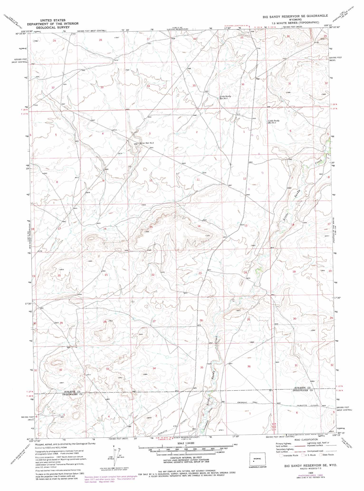
USGS Topo Quad 42109c3 - 1:24,000 scale
| Topo Map Name: | Big Sandy Reservoir Se |
| USGS Topo Quad ID: | 42109c3 |
| Print Size: | ca. 21 1/4" wide x 27" high |
| Southeast Coordinates: | 42.25° N latitude / 109.25° W longitude |
| Map Center Coordinates: | 42.3125° N latitude / 109.3125° W longitude |
| U.S. State: | WY |
| Filename: | o42109c3.jpg |
| Download Map JPG Image: | Big Sandy Reservoir Se topo map 1:24,000 scale |
| Map Type: | Topographic |
| Topo Series: | 7.5´ |
| Map Scale: | 1:24,000 |
| Source of Map Images: | United States Geological Survey (USGS) |
| Alternate Map Versions: |
Big Sandy Reservoir SE WY 1969, updated 1973 Download PDF Buy paper map Big Sandy Reservoir SE WY 1969, updated 1980 Download PDF Buy paper map Big Sandy Reservoir SE WY 2012 Download PDF Buy paper map Big Sandy Reservoir SE WY 2015 Download PDF Buy paper map |
1:24,000 Topo Quads surrounding Big Sandy Reservoir Se
Square Top |
Leckie Sw |
Leckie |
Jensen Meadows |
Sweetwater Needles |
Bull Draw |
Tabernacle Butte |
Leckie Reservoir |
Prospect Mountains |
Halls Meadow Spring |
Juel Spring |
Big Sandy Reservoir |
Big Sandy Reservoir Se |
Parting Of The Ways |
Hay Meadow Reservoir |
Fourmile Knoll |
Eden Reservoir West |
Eden Reservoir East |
Tule Butte |
North Packsaddle Canyon |
Simpson Gulch Se |
Farson |
Fifteenmile Spring |
Ox Yoke Springs |
Essex Mountain |
> Back to 42109a1 at 1:100,000 scale
> Back to 42108a1 at 1:250,000 scale
> Back to U.S. Topo Maps home
Big Sandy Reservoir Se topo map: Gazetteer
Big Sandy Reservoir Se: Canals
Chambers Ditch elevation 2066m 6778′Big Sandy Reservoir Se: Reservoirs
Little Sandy Reservoir Number 2 elevation 2139m 7017′Little Sandy Reservoir Number 3 elevation 2122m 6961′
Big Sandy Reservoir Se: Wells
Spicer Well Number 2 elevation 2098m 6883′Big Sandy Reservoir Se digital topo map on disk
Buy this Big Sandy Reservoir Se topo map showing relief, roads, GPS coordinates and other geographical features, as a high-resolution digital map file on DVD: