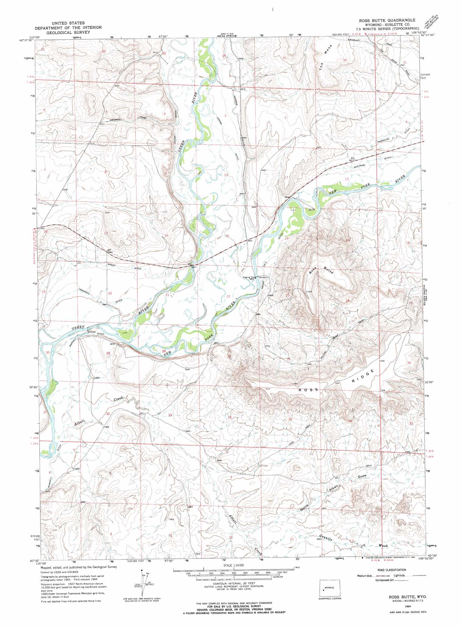
Ross Butte Topo Map Wyoming
To zoom in, hover over the map of Ross Butte
USGS Topo Quad 42109e8 - 1:24,000 scale
| Topo Map Name: | Ross Butte |
| USGS Topo Quad ID: | 42109e8 |
| Print Size: | ca. 21 1/4" wide x 27" high |
| Southeast Coordinates: | 42.5° N latitude / 109.875° W longitude |
| Map Center Coordinates: | 42.5625° N latitude / 109.9375° W longitude |
| U.S. State: | WY |
| Filename: | o42109e8.jpg |
| Download Map JPG Image: | Ross Butte topo map 1:24,000 scale |
| Map Type: | Topographic |
| Topo Series: | 7.5´ |
| Map Scale: | 1:24,000 |
| Source of Map Images: | United States Geological Survey (USGS) |
| Alternate Map Versions: |
Ross Butte WY 1964, updated 1968 Download PDF Buy paper map Ross Butte WY 1964, updated 1968 Download PDF Buy paper map Ross Butte WY 2012 Download PDF Buy paper map Ross Butte WY 2015 Download PDF Buy paper map |
1:24,000 Topo Quads surrounding Ross Butte
Onion Springs |
Daniel |
Mount Airy |
Pinedale |
Boulder Lake |
Budd Reservoir |
Ball Island |
Mesa Spring |
Two Buttes Reservoir |
Boulder |
Big Piney West |
Big Piney East |
Ross Butte |
Olsen Ranch |
Gobblers Knob |
Chimney Butte |
Milleson Draw |
Sugar Loaf Nw |
Sugar Loaf Ne |
Stud Horse Butte |
La Barge |
La Barge Se |
Oasis Well |
Sugar Loaf |
Teakettle Butte |
> Back to 42109e1 at 1:100,000 scale
> Back to 42108a1 at 1:250,000 scale
> Back to U.S. Topo Maps home
Ross Butte topo map: Gazetteer
Ross Butte: Canals
Crandall Ditch elevation 2078m 6817′Hanna Ditch elevation 2092m 6863′
Hanna Number 2 Ditch elevation 2082m 6830′
Paradise Ditch elevation 2111m 6925′
Sheep Ditch elevation 2090m 6856′
Wardell Ditch elevation 2068m 6784′
Ross Butte: Ridges
Ross Ridge elevation 2261m 7417′Ross Butte: Streams
Alkali Creek elevation 2064m 6771′New Fork River elevation 2069m 6788′
Ross Butte: Summits
Ross Butte elevation 2280m 7480′Ross Butte: Valleys
Granite Wash elevation 2090m 6856′North Alkali Draw elevation 2089m 6853′
Ross Butte digital topo map on disk
Buy this Ross Butte topo map showing relief, roads, GPS coordinates and other geographical features, as a high-resolution digital map file on DVD: