Fremont Lake South Topo Map Wyoming
To zoom in, hover over the map of Fremont Lake South
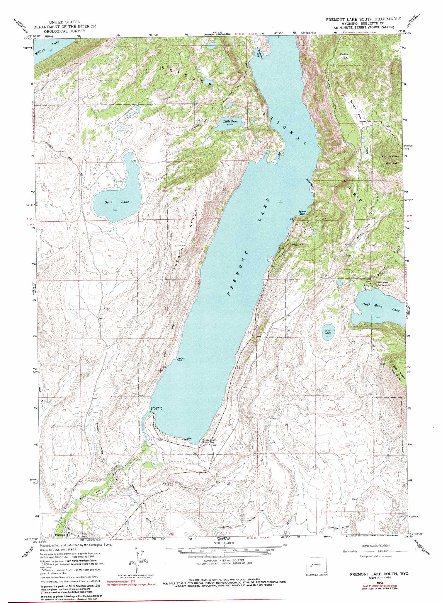
USGS Topo Quad 42109h7 - 1:24,000 scale
| Topo Map Name: | Fremont Lake South |
| USGS Topo Quad ID: | 42109h7 |
| Print Size: | ca. 21 1/4" wide x 27" high |
| Southeast Coordinates: | 42.875° N latitude / 109.75° W longitude |
| Map Center Coordinates: | 42.9375° N latitude / 109.8125° W longitude |
| U.S. State: | WY |
| Filename: | o42109h7.jpg |
| Download Map JPG Image: | Fremont Lake South topo map 1:24,000 scale |
| Map Type: | Topographic |
| Topo Series: | 7.5´ |
| Map Scale: | 1:24,000 |
| Source of Map Images: | United States Geological Survey (USGS) |
| Alternate Map Versions: |
Fremont Lake South WY 1964, updated 1978 Download PDF Buy paper map Fremont Lake South WY 1964, updated 1986 Download PDF Buy paper map Fremont Lake South WY 1964, updated 1986 Download PDF Buy paper map Fremont Lake South WY 2012 Download PDF Buy paper map Fremont Lake South WY 2015 Download PDF Buy paper map |
| FStopo: | US Forest Service topo Fremont Lake South is available: Download FStopo PDF Download FStopo TIF |
1:24,000 Topo Quads surrounding Fremont Lake South
Dodge Butte |
Kendall Mountain |
Squaretop Mountain |
Gannett Peak |
Fremont Peak North |
Warren Bridge |
New Fork Lakes |
Fremont Lake North |
Bridger Lakes |
Fremont Peak South |
Daniel Junction |
Cora |
Fremont Lake South |
Fayette Lake |
Horseshoe Lake |
Daniel |
Mount Airy |
Pinedale |
Boulder Lake |
Scab Creek |
Ball Island |
Mesa Spring |
Two Buttes Reservoir |
Boulder |
Fremont Butte |
> Back to 42109e1 at 1:100,000 scale
> Back to 42108a1 at 1:250,000 scale
> Back to U.S. Topo Maps home
Fremont Lake South topo map: Gazetteer
Fremont Lake South: Bays
Beaver Bay elevation 2262m 7421′Box Bay elevation 2262m 7421′
Chambers Bay elevation 2262m 7421′
Sylvan Bay elevation 2262m 7421′
Fremont Lake South: Canals
Fremont Ditch elevation 2254m 7395′Fremont Lake South: Capes
Higgins Point elevation 2263m 7424′Fremont Lake South: Flats
Kelly Park elevation 2463m 8080′Mulligan Park elevation 2694m 8838′
Surveyor Park elevation 2563m 8408′
Fremont Lake South: Islands
Willow Island elevation 2211m 7253′Fremont Lake South: Lakes
Little Soda Lake elevation 2322m 7618′Mud Lake elevation 2291m 7516′
Soda Lake elevation 2300m 7545′
Fremont Lake South: Mines
Fremont Ridge Mine elevation 2396m 7860′Fremont Lake South: Populated Places
Sylvan Bay Summer Home Area elevation 2265m 7431′Fremont Lake South: Reservoirs
Fremont Lake elevation 2262m 7421′Fremont Lake South: Ridges
Fremont Ridge elevation 2509m 8231′Fremont Lake South: Streams
Spring Creek elevation 2336m 7664′Surveyor Creek elevation 2318m 7604′
Sweeney Creek elevation 2318m 7604′
Fremont Lake South: Trails
Park Loop Ski Trail elevation 2488m 8162′Summit Lake Trail elevation 2360m 7742′
Fremont Lake South digital topo map on disk
Buy this Fremont Lake South topo map showing relief, roads, GPS coordinates and other geographical features, as a high-resolution digital map file on DVD: