Nugent Park Topo Map Wyoming
To zoom in, hover over the map of Nugent Park
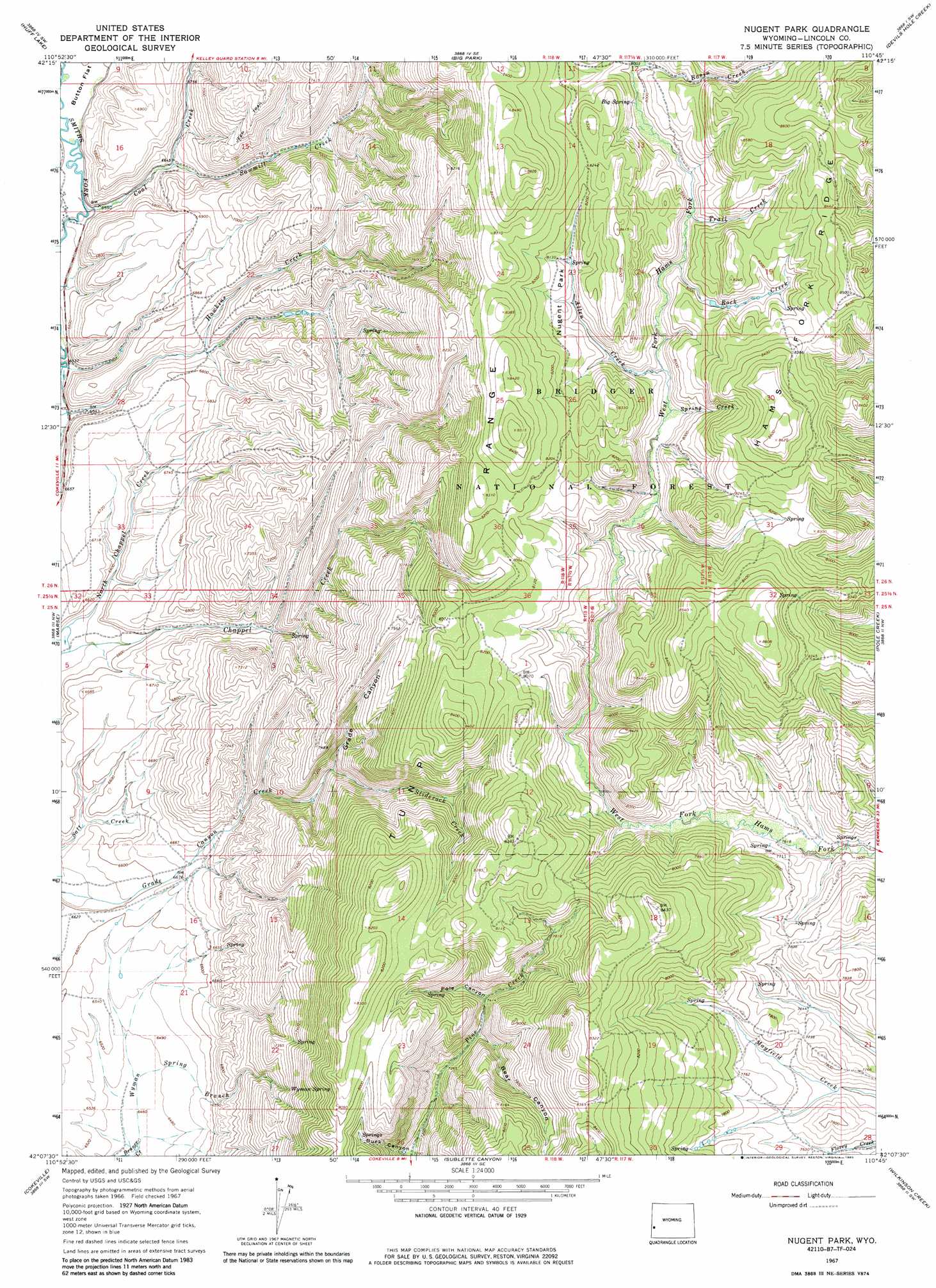
USGS Topo Quad 42110b7 - 1:24,000 scale
| Topo Map Name: | Nugent Park |
| USGS Topo Quad ID: | 42110b7 |
| Print Size: | ca. 21 1/4" wide x 27" high |
| Southeast Coordinates: | 42.125° N latitude / 110.75° W longitude |
| Map Center Coordinates: | 42.1875° N latitude / 110.8125° W longitude |
| U.S. State: | WY |
| Filename: | o42110b7.jpg |
| Download Map JPG Image: | Nugent Park topo map 1:24,000 scale |
| Map Type: | Topographic |
| Topo Series: | 7.5´ |
| Map Scale: | 1:24,000 |
| Source of Map Images: | United States Geological Survey (USGS) |
| Alternate Map Versions: |
Nugent Park WY 1967, updated 1971 Download PDF Buy paper map Nugent Park WY 1967, updated 1985 Download PDF Buy paper map Nugent Park WY 2012 Download PDF Buy paper map Nugent Park WY 2015 Download PDF Buy paper map |
| FStopo: | US Forest Service topo Nugent Park is available: Download FStopo PDF Download FStopo TIF |
1:24,000 Topo Quads surrounding Nugent Park
Giraffe Creek |
Salt Flat |
Porcupine Creek |
Graham Peak |
Mount Thompson |
Geneva |
Huff Lake |
Big Park |
Devils Hole Creek |
Coal Creek |
Border |
Marse |
Nugent Park |
Pole Creek |
Fontenelle Basin |
Boundary Ridge |
Cokeville |
Sublette Canyon |
Wilkinson Creek |
South Fork Mountain |
South Lake |
Beckwith |
The Rock Slide |
Kemmerer Reservoir |
Sublet |
> Back to 42110a1 at 1:100,000 scale
> Back to 42110a1 at 1:250,000 scale
> Back to U.S. Topo Maps home
Nugent Park topo map: Gazetteer
Nugent Park: Mines
Smiths Fork Mine elevation 2076m 6811′West Branch Hams Fork Creek Mine elevation 2454m 8051′
Nugent Park: Parks
Nugent Park elevation 2432m 7979′Nugent Park: Ranges
Tunp Range elevation 2544m 8346′Nugent Park: Ridges
Hams Fork Ridge elevation 2626m 8615′Nugent Park: Springs
Big Spring elevation 2427m 7962′Wyman Spring elevation 2227m 7306′
Nugent Park: Streams
Allen Creek elevation 2387m 7831′Basin Creek elevation 2440m 8005′
Coal Creek elevation 2000m 6561′
Kelley Creek elevation 2436m 7992′
North Chappel Creek elevation 1983m 6505′
Rock Creek elevation 2427m 7962′
Sawmill Creek elevation 2026m 6646′
Sliderock Creek elevation 2153m 7063′
Spring Creek elevation 2399m 7870′
Trail Creek elevation 2429m 7969′
Wyman Spring Branch elevation 1965m 6446′
Nugent Park: Valleys
Bear Canyon elevation 2264m 7427′Buck Canyon elevation 2170m 7119′
Grade Canyon elevation 2169m 7116′
Pole Canyon elevation 2265m 7431′
Nugent Park digital topo map on disk
Buy this Nugent Park topo map showing relief, roads, GPS coordinates and other geographical features, as a high-resolution digital map file on DVD: