Huff Lake Topo Map Wyoming
To zoom in, hover over the map of Huff Lake
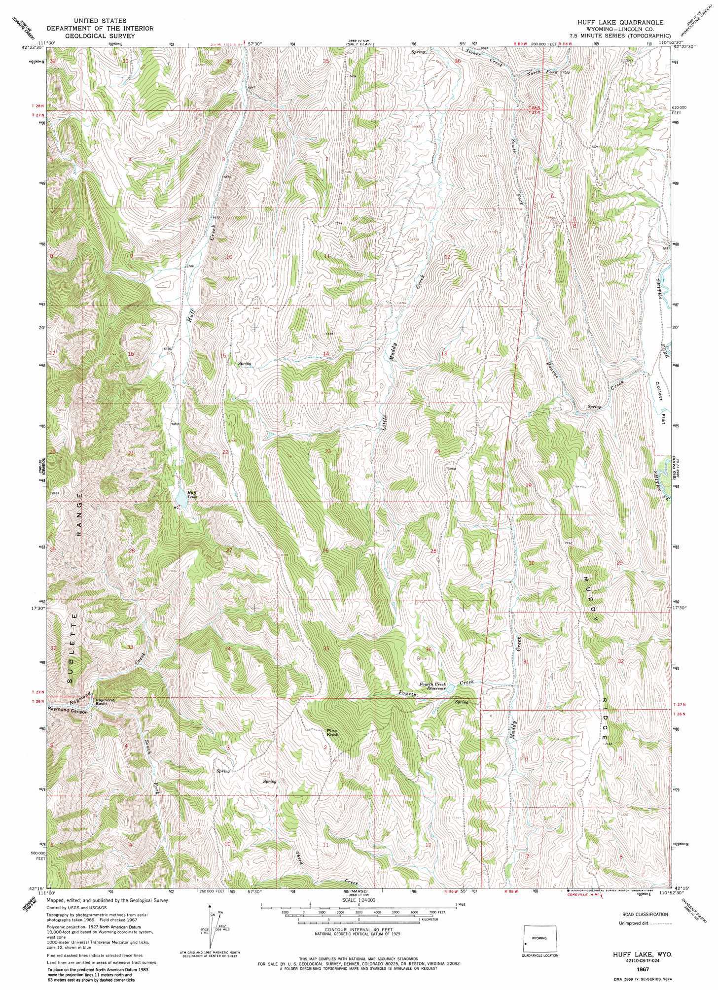
USGS Topo Quad 42110c8 - 1:24,000 scale
| Topo Map Name: | Huff Lake |
| USGS Topo Quad ID: | 42110c8 |
| Print Size: | ca. 21 1/4" wide x 27" high |
| Southeast Coordinates: | 42.25° N latitude / 110.875° W longitude |
| Map Center Coordinates: | 42.3125° N latitude / 110.9375° W longitude |
| U.S. State: | WY |
| Filename: | o42110c8.jpg |
| Download Map JPG Image: | Huff Lake topo map 1:24,000 scale |
| Map Type: | Topographic |
| Topo Series: | 7.5´ |
| Map Scale: | 1:24,000 |
| Source of Map Images: | United States Geological Survey (USGS) |
| Alternate Map Versions: |
Huff Lake WY 1967, updated 1970 Download PDF Buy paper map Huff Lake WY 1967, updated 1984 Download PDF Buy paper map Huff Lake WY 2012 Download PDF Buy paper map Huff Lake WY 2015 Download PDF Buy paper map |
1:24,000 Topo Quads surrounding Huff Lake
Snowdrift Mountain |
Elk Valley |
Smoot |
Mount Wagner |
Poison Meadows |
Meade Peak |
Giraffe Creek |
Salt Flat |
Porcupine Creek |
Graham Peak |
Montpelier Canyon |
Geneva |
Huff Lake |
Big Park |
Devils Hole Creek |
Pegram |
Border |
Marse |
Nugent Park |
Pole Creek |
Pegram Creek |
Boundary Ridge |
Cokeville |
Sublette Canyon |
Wilkinson Creek |
> Back to 42110a1 at 1:100,000 scale
> Back to 42110a1 at 1:250,000 scale
> Back to U.S. Topo Maps home
Huff Lake topo map: Gazetteer
Huff Lake: Basins
Raymond Basin elevation 2067m 6781′Huff Lake: Flats
Collett Flat elevation 2072m 6797′Huff Lake: Lakes
Huff Lake elevation 2143m 7030′Huff Lake: Mines
Sublette Ridge Mine elevation 2489m 8166′Huff Lake: Reservoirs
Fourth Creek Reservoir elevation 2162m 7093′Huff Lake: Streams
Bourne Creek elevation 2064m 6771′Claudia Creek elevation 2076m 6811′
Fourth Creek elevation 2119m 6952′
North Fork Stoner Creek elevation 2067m 6781′
South Fork Raymond Creek elevation 2067m 6781′
South Fork Stoner Creek elevation 2058m 6751′
Huff Lake: Summits
Pine Knoll elevation 2543m 8343′Huff Lake digital topo map on disk
Buy this Huff Lake topo map showing relief, roads, GPS coordinates and other geographical features, as a high-resolution digital map file on DVD: