Milleson Draw Topo Map Wyoming
To zoom in, hover over the map of Milleson Draw
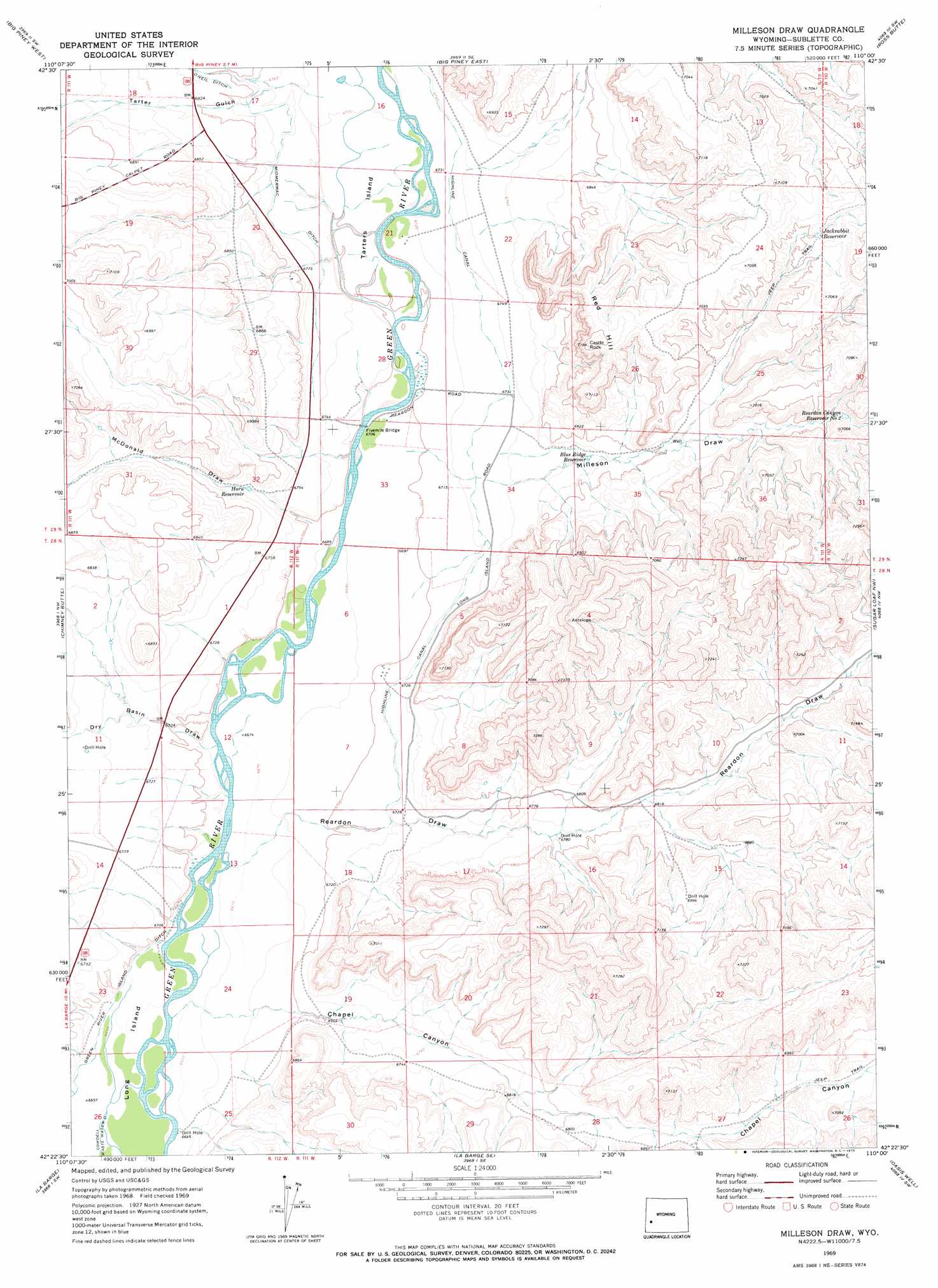
USGS Topo Quad 42110d1 - 1:24,000 scale
| Topo Map Name: | Milleson Draw |
| USGS Topo Quad ID: | 42110d1 |
| Print Size: | ca. 21 1/4" wide x 27" high |
| Southeast Coordinates: | 42.375° N latitude / 110° W longitude |
| Map Center Coordinates: | 42.4375° N latitude / 110.0625° W longitude |
| U.S. State: | WY |
| Filename: | o42110d1.jpg |
| Download Map JPG Image: | Milleson Draw topo map 1:24,000 scale |
| Map Type: | Topographic |
| Topo Series: | 7.5´ |
| Map Scale: | 1:24,000 |
| Source of Map Images: | United States Geological Survey (USGS) |
| Alternate Map Versions: |
Milleson Draw WY 1969, updated 1973 Download PDF Buy paper map Milleson Draw WY 2012 Download PDF Buy paper map Milleson Draw WY 2015 Download PDF Buy paper map |
1:24,000 Topo Quads surrounding Milleson Draw
Meadow Canyon |
Budd Reservoir |
Ball Island |
Mesa Spring |
Two Buttes Reservoir |
Deer Hill |
Big Piney West |
Big Piney East |
Ross Butte |
Olsen Ranch |
Cretaceous Mountain |
Chimney Butte |
Milleson Draw |
Sugar Loaf Nw |
Sugar Loaf Ne |
The Hogsback |
La Barge |
La Barge Se |
Oasis Well |
Sugar Loaf |
Red Gap |
Names Hill |
Anderson Canyon |
Monument Butte |
Monument Butte Ne |
> Back to 42110a1 at 1:100,000 scale
> Back to 42110a1 at 1:250,000 scale
> Back to U.S. Topo Maps home
Milleson Draw topo map: Gazetteer
Milleson Draw: Bridges
Fivemile Bridge elevation 2039m 6689′Milleson Draw: Canals
Green River Island Ditch elevation 2030m 6660′Highline Canal elevation 2052m 6732′
Midmermac Ditch elevation 2061m 6761′
Milleson Draw: Islands
Long Island elevation 2027m 6650′Tarters Island elevation 2045m 6709′
Milleson Draw: Reservoirs
Blue Ridge Reservoir elevation 2063m 6768′Horn Reservoir elevation 2058m 6751′
Jackrabbit Reservoir elevation 2135m 7004′
Reardon Canyon Reservoir Number 2 elevation 2109m 6919′
Reardon Reservoir Number 3 elevation 2130m 6988′
Milleson Draw: Streams
Dry Piney Creek elevation 2032m 6666′Milleson Draw: Summits
Castle Rock elevation 2180m 7152′Red Hill elevation 2179m 7148′
Milleson Draw: Valleys
Chapel Canyon elevation 2041m 6696′Dry Basin Draw elevation 2036m 6679′
McDonald Draw elevation 2042m 6699′
Milleson Draw elevation 2053m 6735′
Reardon Draw elevation 2037m 6683′
Tarter Gulch elevation 2054m 6738′
Milleson Draw digital topo map on disk
Buy this Milleson Draw topo map showing relief, roads, GPS coordinates and other geographical features, as a high-resolution digital map file on DVD: