Cretaceous Mountain Topo Map Wyoming
To zoom in, hover over the map of Cretaceous Mountain
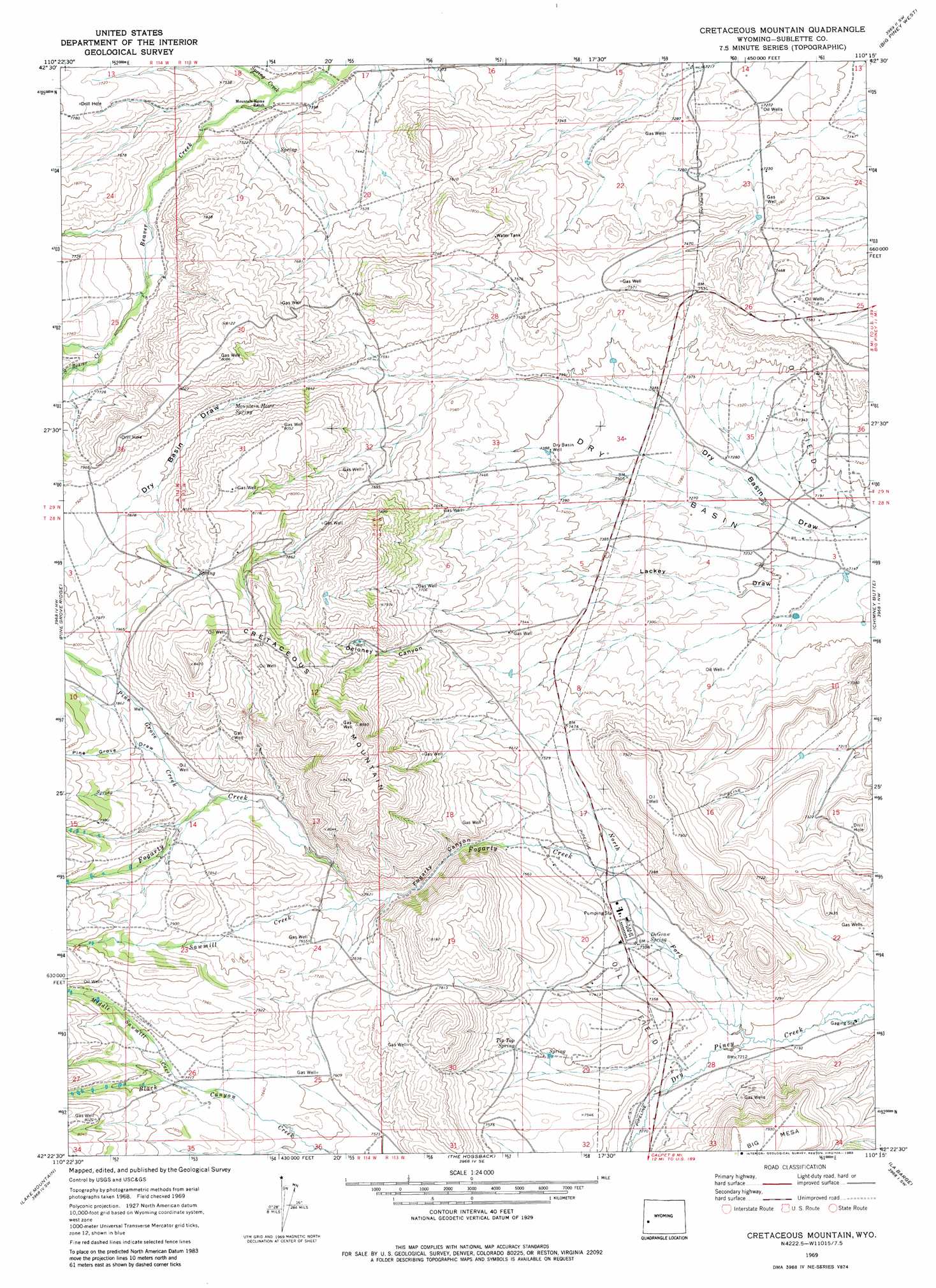
USGS Topo Quad 42110d3 - 1:24,000 scale
| Topo Map Name: | Cretaceous Mountain |
| USGS Topo Quad ID: | 42110d3 |
| Print Size: | ca. 21 1/4" wide x 27" high |
| Southeast Coordinates: | 42.375° N latitude / 110.25° W longitude |
| Map Center Coordinates: | 42.4375° N latitude / 110.3125° W longitude |
| U.S. State: | WY |
| Filename: | o42110d3.jpg |
| Download Map JPG Image: | Cretaceous Mountain topo map 1:24,000 scale |
| Map Type: | Topographic |
| Topo Series: | 7.5´ |
| Map Scale: | 1:24,000 |
| Source of Map Images: | United States Geological Survey (USGS) |
| Alternate Map Versions: |
Cretaceous Mountain WY 1969, updated 1973 Download PDF Buy paper map Cretaceous Mountain WY 1969, updated 1983 Download PDF Buy paper map Cretaceous Mountain WY 2012 Download PDF Buy paper map Cretaceous Mountain WY 2015 Download PDF Buy paper map |
1:24,000 Topo Quads surrounding Cretaceous Mountain
Mount Schidler |
Red Castle Creek |
Meadow Canyon |
Budd Reservoir |
Ball Island |
Wyoming Peak |
Springman Creek |
Deer Hill |
Big Piney West |
Big Piney East |
Mount Thompson |
Pine Grove Ridge |
Cretaceous Mountain |
Chimney Butte |
Milleson Draw |
Coal Creek |
Lake Mountain |
The Hogsback |
La Barge |
La Barge Se |
Fontenelle Basin |
Fort Hill |
Red Gap |
Names Hill |
Anderson Canyon |
> Back to 42110a1 at 1:100,000 scale
> Back to 42110a1 at 1:250,000 scale
> Back to U.S. Topo Maps home
Cretaceous Mountain topo map: Gazetteer
Cretaceous Mountain: Basins
Dry Basin elevation 2220m 7283′Cretaceous Mountain: Mines
Griggs Prospect elevation 2530m 8300′Cretaceous Mountain: Springs
DeGraw Spring elevation 2226m 7303′Mountain Home Spring elevation 2352m 7716′
Tip Top Spring elevation 2269m 7444′
Cretaceous Mountain: Streams
Black Canyon Creek elevation 2349m 7706′Fogarty Creek elevation 2241m 7352′
North Fork Dry Piney Creek elevation 2195m 7201′
Pine Grove Creek elevation 2340m 7677′
Sawmill Creek elevation 2303m 7555′
South Beaver Creek elevation 2326m 7631′
Cretaceous Mountain: Summits
Cretaceous Mountain elevation 2616m 8582′Cretaceous Mountain: Valleys
Black Canyon elevation 2368m 7769′Deloney Canyon elevation 2301m 7549′
Fogarty Canyon elevation 2267m 7437′
Pine Grove Draw elevation 2366m 7762′
Cretaceous Mountain: Wells
Dry Basin Well elevation 2252m 7388′Cretaceous Mountain digital topo map on disk
Buy this Cretaceous Mountain topo map showing relief, roads, GPS coordinates and other geographical features, as a high-resolution digital map file on DVD: