Red Castle Creek Topo Map Wyoming
To zoom in, hover over the map of Red Castle Creek
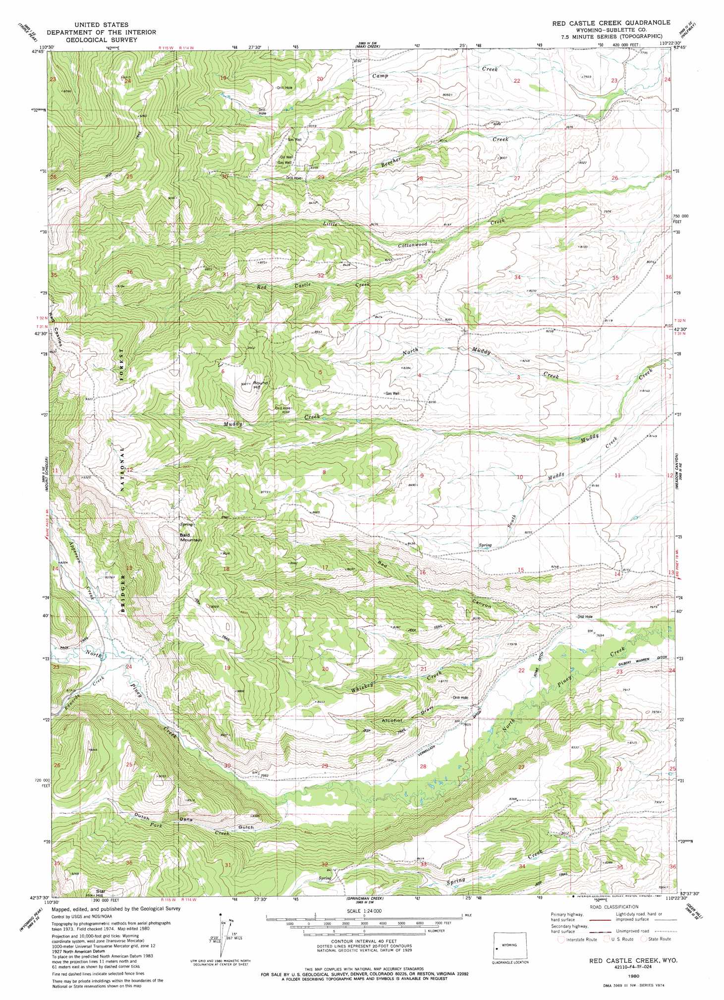
USGS Topo Quad 42110f4 - 1:24,000 scale
| Topo Map Name: | Red Castle Creek |
| USGS Topo Quad ID: | 42110f4 |
| Print Size: | ca. 21 1/4" wide x 27" high |
| Southeast Coordinates: | 42.625° N latitude / 110.375° W longitude |
| Map Center Coordinates: | 42.6875° N latitude / 110.4375° W longitude |
| U.S. State: | WY |
| Filename: | o42110f4.jpg |
| Download Map JPG Image: | Red Castle Creek topo map 1:24,000 scale |
| Map Type: | Topographic |
| Topo Series: | 7.5´ |
| Map Scale: | 1:24,000 |
| Source of Map Images: | United States Geological Survey (USGS) |
| Alternate Map Versions: |
Red Castle Creek WY 1980, updated 1980 Download PDF Buy paper map Red Castle Creek WY 1980, updated 1987 Download PDF Buy paper map Red Castle Creek WY 2012 Download PDF Buy paper map Red Castle Creek WY 2015 Download PDF Buy paper map |
| FStopo: | US Forest Service topo Red Castle Creek is available: Download FStopo PDF Download FStopo TIF |
1:24,000 Topo Quads surrounding Red Castle Creek
Blind Bull Creek |
Lookout Mountain |
Prospect Peak |
Merna Butte |
Webb Draw |
Park Creek |
Triple Peak |
Maki Creek |
Halfway |
Onion Springs |
Box Canyon Creek |
Mount Schidler |
Red Castle Creek |
Meadow Canyon |
Budd Reservoir |
Poison Meadows |
Wyoming Peak |
Springman Creek |
Deer Hill |
Big Piney West |
Graham Peak |
Mount Thompson |
Pine Grove Ridge |
Cretaceous Mountain |
Chimney Butte |
> Back to 42110e1 at 1:100,000 scale
> Back to 42110a1 at 1:250,000 scale
> Back to U.S. Topo Maps home
Red Castle Creek topo map: Gazetteer
Red Castle Creek: Areas
Red Castles elevation 2906m 9534′Red Castle Creek: Canals
Rowe Ditch elevation 2355m 7726′Vermillion Ditch elevation 2379m 7805′
Red Castle Creek: Streams
Apperson Creek elevation 2467m 8093′Camp Creek elevation 2369m 7772′
Edwards Creek elevation 2462m 8077′
North Muddy Creek elevation 2445m 8021′
Park Creek elevation 2408m 7900′
Red Castle Creek elevation 2448m 8031′
Whiskey Creek elevation 2326m 7631′
Red Castle Creek: Summits
Bald Mountain elevation 2908m 9540′Round Hill elevation 2748m 9015′
Star Hill elevation 2891m 9484′
Red Castle Creek: Valleys
Alcohol Draw elevation 2375m 7791′Dutch Dans Gulch elevation 2409m 7903′
Red Canyon elevation 2340m 7677′
Red Castle Creek digital topo map on disk
Buy this Red Castle Creek topo map showing relief, roads, GPS coordinates and other geographical features, as a high-resolution digital map file on DVD: