Park Creek Topo Map Wyoming
To zoom in, hover over the map of Park Creek
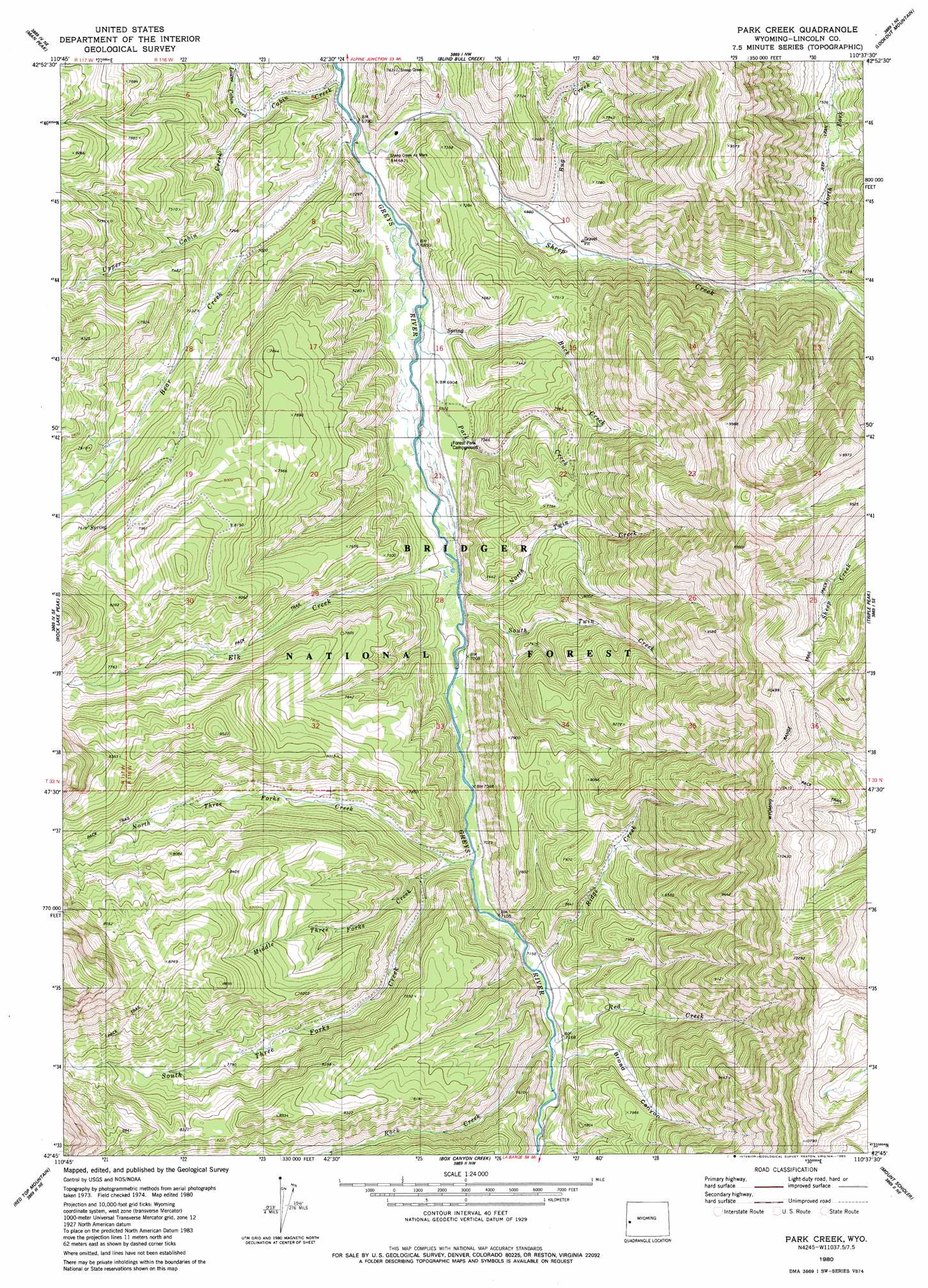
USGS Topo Quad 42110g6 - 1:24,000 scale
| Topo Map Name: | Park Creek |
| USGS Topo Quad ID: | 42110g6 |
| Print Size: | ca. 21 1/4" wide x 27" high |
| Southeast Coordinates: | 42.75° N latitude / 110.625° W longitude |
| Map Center Coordinates: | 42.8125° N latitude / 110.6875° W longitude |
| U.S. State: | WY |
| Filename: | o42110g6.jpg |
| Download Map JPG Image: | Park Creek topo map 1:24,000 scale |
| Map Type: | Topographic |
| Topo Series: | 7.5´ |
| Map Scale: | 1:24,000 |
| Source of Map Images: | United States Geological Survey (USGS) |
| Alternate Map Versions: |
Park Creek WY 1980, updated 1980 Download PDF Buy paper map Park Creek WY 1980, updated 1980 Download PDF Buy paper map Park Creek WY 2012 Download PDF Buy paper map Park Creek WY 2015 Download PDF Buy paper map |
| FStopo: | US Forest Service topo Park Creek is available: Download FStopo PDF Download FStopo TIF |
1:24,000 Topo Quads surrounding Park Creek
Stewart Peak |
Deer Creek |
Pickle Pass |
Hoback Peak |
Noble Basin |
Thayne East |
Man Peak |
Blind Bull Creek |
Lookout Mountain |
Prospect Peak |
Grover |
Rock Lake Peak |
Park Creek |
Triple Peak |
Maki Creek |
Afton |
Red Top Mountain |
Box Canyon Creek |
Mount Schidler |
Red Castle Creek |
Smoot |
Mount Wagner |
Poison Meadows |
Wyoming Peak |
Springman Creek |
> Back to 42110e1 at 1:100,000 scale
> Back to 42110a1 at 1:250,000 scale
> Back to U.S. Topo Maps home
Park Creek topo map: Gazetteer
Park Creek: Mines
Sheep Creek Canyon Mine elevation 2271m 7450′Park Creek: Springs
Young Spring elevation 2087m 6847′Park Creek: Streams
Bear Creek elevation 2072m 6797′Buck Creek elevation 2089m 6853′
Bug Creek elevation 2128m 6981′
Cabin Creek elevation 2066m 6778′
Elk Creek elevation 2118m 6948′
Lower Cabin Creek elevation 2102m 6896′
Middle Three Forks Creek elevation 2185m 7168′
North Fork Sheep Creek elevation 2217m 7273′
North Three Forks Creek elevation 2158m 7080′
North Twin Creek elevation 2127m 6978′
Park Creek elevation 2089m 6853′
Red Creek elevation 2186m 7171′
Ridge Creek elevation 2176m 7139′
Rock Creek elevation 2182m 7158′
Sheep Creek elevation 2071m 6794′
Sheep Creek elevation 2075m 6807′
South Three Forks Creek elevation 2166m 7106′
South Twin Creek elevation 2128m 6981′
Upper Cabin Creek elevation 2102m 6896′
Park Creek: Trails
Wyoming Range Trail elevation 3033m 9950′Park Creek: Valleys
Broad Canyon elevation 2187m 7175′Young Canyon elevation 2088m 6850′
Park Creek digital topo map on disk
Buy this Park Creek topo map showing relief, roads, GPS coordinates and other geographical features, as a high-resolution digital map file on DVD: